Introduction
The recent incidents at the Pangong Tso lake area between Indian and Chinese soldiers on the LAC can be considered to be a serious business between two nuclear armed trans-Himalayan neighbours that has implications beyond the region.
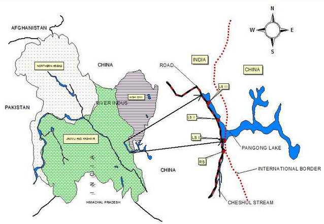
Line of Actual Control

- The disputed boundary between India and China, also known as the Line of Actual Control (LAC), is divided into three sectors: western, middle and eastern.
- The countries disagree on the exact location of the LAC in various areas, so much so that India claims that the LAC is 3,488 km long while the Chinese believe it to be around 2,000 km long.
- The two armies try and dominate by patrol to the areas up to their respective perceptions of the LAC, often bringing them into conflict and leading to incidents such as those witnessed in Naku La in Sikkim earlier this month.
- The LAC mostly passes on the land, but Pangong Tso is a unique case where it passes through the water as well. The points in the water at which the Indian claim ends and Chinese claim begins are not agreed upon mutually.
The Pangong Tso lake
- Pangong Tso lake in eastern Ladakh has often been in the news, most famously during the Doklam standoff.
- Pangong Tso is a long narrow, deep, endorheic (landlocked) lake situated at a height of more than 14,000 ft in the Ladakh Himalayas. The western end of Tso lies 54 km to the southeast of Leh. The 135 km-long lake sprawls over 604 sq km in the shape of a boomerang, and is 6 km wide at its broadest point.
Tactical significance of the Panging Tso
- By itself, the lake does not have major tactical significance. But it lies in the path of the Chushul approach, one of the main approaches that China can use for an offensive into Indian-held territory.
- Indian assessments show that a major Chinese offensive, if it comes, will flow across both the north and south of the lake.
- During the 1962 war, this was where China launched its main offensive.
- Over the years, the Chinese have built motorable roads along their banks of the Pangong Tso.
Even during peacetime, the difference in perception over where the LAC lies on the northern bank of the lake, makes this contested terrain. - In 1999, when the Army unit from the area was moved to Kargil for Operation Vijay, China took the opportunity to build 5 km of road inside Indian territory along the lake’s bank.
Fingers in the lake
The barren mountains on the lake’s northern bank, called the Chang Chenmo, jut forward in major spurs, which the Army calls “fingers”.
India claims that the LAC is coterminous with Finger 8, but it physically controls area only up to Finger 4.
- Chinese use light vehicles on the road to patrol up to Finger 2, which has a turning point for their vehicles.
- If they are confronted and stopped by an Indian patrol in between, asking them to return, it leads to confusion, as the vehicles can’t turn back.
The Chinese have now stopped the Indian soldiers moving beyond Finger 2.
Confrontation on the water
- On the water, the Chinese had a major advantage until a few years ago — their superior boats could literally run circles around the Indian boats.
- But India purchased better Tampa boats some eight years ago, leading to a quicker and more aggressive response.
Out of bounds for tourists
- Tourists were not allowed at all at Pangong Tso until 1999, and even today, you need to obtain an Inner Line Permit from the office of the Deputy Commissioner at Leh.
- Tourists are only allowed up to Spangmik village, around 7 km into the lake.
-Source: Indian Express