Context:
An earthquake measuring 5.4 on the Richter scale struck the Sikkim-Bhutan border and the tremors were felt in the districts of north Bengal including Siliguri, Malda and Darjeeling districts.
Relevance:
GS-I: Geography (Geomorphology, Important Geographical Phenomenon, Earthquakes), GS-III: Disaster Management
Dimensions of the Article:
- Earthquake
- Earthquake Waves
- Earthquake zones of India
- Measurement of earthquakes
Earthquake
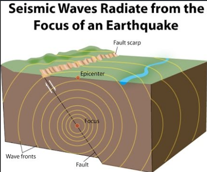
- An earthquake is shaking of the earth. It is a natural event. It is caused due to release of energy, which generates waves that travel in all directions.
- The release of energy occurs along a fault. Rocks along a fault tend to move in opposite directions. This causes a release of energy, and the energy waves travel in all directions.
- The point where the energy is released is called the focus of an earthquake, alternatively, it is called the hypocentre.
- The point on the surface, nearest to the focus, is called epicentre. It is the first one to experience the waves. It is a point directly above the focus.
Earthquake Waves
- All-natural earthquakes take place in the lithosphere.
- Earthquake waves are basically of two types body waves and surface waves.
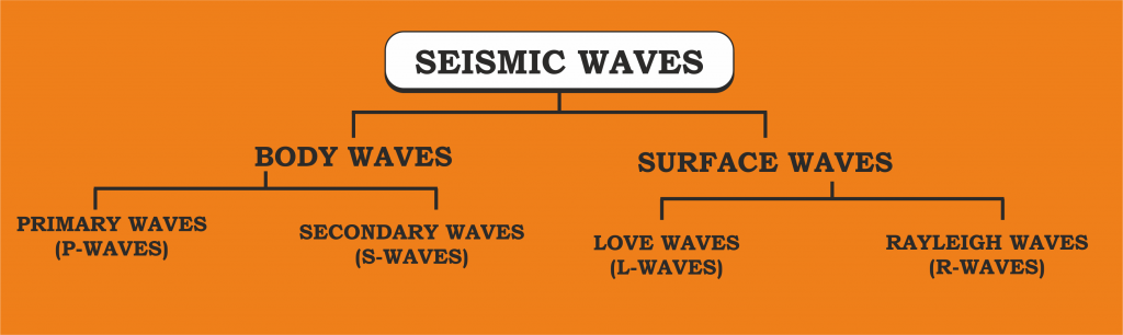
Body Waves
Body waves are generated due to the release of energy at the focus and move in all directions travelling through the body of the earth.
There are 2 types of body waves and they are, Primary waves [P] and Secondary [S] waves
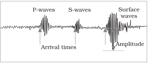
- Primary waves [P]: Primary waves are the first to appear on the surface and hence the name P waves.
- P-waves vibrate parallel to the direction of the wave. This exerts pressure on the material in the direction of the propagation
- P waves can travel through gaseous, liquid and solid materials.
- Secondary waves [S]: Secondary waves or S waves appear after P waves. The direction of vibrations of S-waves is perpendicular to the wave direction in the vertical plane. Hence, they create troughs and crests in the material through which they pass
Surface waves
- The body waves interact with the surface rocks and generate new set of waves called surface waves. These waves move along the surface.
- The velocity of waves changes as they travel through materials with different densities. The denser the material, the higher is the velocity.
- Their direction also changes as they reflect or refract when coming across materials with different densities.
- Surface waves are considered to be the most damaging waves.
Earthquake zones of India
- The major reason for the high frequency and intensity of the earthquakes is that the Indian plate is driving into Asia at a rate of approximately 47 mm/year.
- Geographical statistics of India show that more than 50% of the land is vulnerable to earthquakes.
- The latest version of seismic zoning map of India divides India into 4 seismic zones (Zone 2, 3, 4 and 5).
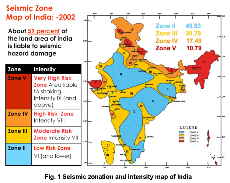
Zones of Seismicity
- Zone 1: Currently the Division does not include a Zone 1. NO area of India is classed as Zone 1.
- Zone 2: This region is liable to MSK VI or less and is classified as the Low Damage Risk Zone.
- Zone 3: This zone is classified as Moderate Damage Risk Zone which is liable to MSK VII.
- Zone 4: This zone is called the High Damage Risk Zone and covers areas liable to MSK VIII. Jammu and Kashmir, Ladakh, Himachal Pradesh, Uttarakhand, Sikkim, the parts of Indo-Gangetic plains (North Punjab, Chandigarh, Western Uttar Pradesh, Terai, North Bengal, Sundarbans) and the capital of the country Delhi fall in Zone 4.
- Zone 5: Zone 5 covers the areas with the highest risks zone that suffers earthquakes of intensity MSK IX or greater. The region of Kashmir, the Western and Central Himalayas, North and Middle Bihar, the North-East Indian region, the Rann of Kutch and the Andaman and Nicobar group of islands fall in this zone.
Measurement of earthquakes
The earthquake events are scaled either according to the magnitude or intensity of the shock.
- Richter scale – The magnitude scale is known as the Richter scale. The magnitude relates to the energy released during the quake. The magnitude is expressed in absolute numbers, 0-10.
- Mercalli scale – The intensity scale is named after Mercalli, an Italian seismologist. The intensity scale takes into account the visible damage caused by the event. The range of intensity scale is from 1-12.
- Medvedev–Sponheuer–Karnik scale – This is a macroseismic intensity scale used to evaluate the severity of ground shaking on the basis of observed effects in an area of the earthquake occurrence.
-Source: The Hindu


