Focus: GS-I Geography, GS-III Disaster Management
Introduction
- Like most hill townships, Mussoorie, the popular hill station in Uttarakhand, has witnessed several landslides, probably resulting from an increased spate of developmental activities.
- The increased disaster hazard has led scientists to map the landslide susceptibility of Mussoorie and surrounding areas, showing that 15 percent of the region is highly susceptible to landslides.
Details
- Scientists carried out the study in Mussoorie township and its surroundings covering 84 square km in the Lesser Himalaya.
- They found that dominant part of the area falling under very high and high landslide susceptible zone lies in the settlement areas and are covered by highly fractured Krol limestone exhibiting slope more than 60 degrees.
- The Landslide Susceptibility Mapping (LSM) published showed that about 29% of the area falls in the moderate landslide susceptible zone and 56% in low to very low landslide susceptible zone.
Introduction to Landslides
What are Landslides?
Landslides are physical mass movement of soil, rocks and debris down the mountain slope because of heavy rainfall, earthquake, gravity and other factors.
Why do Landslides Occur?
- Base of the huge mountains eroded by rivers or due to mining activities or erosion agents resulting in steep slopes.
- Increased industrialisation leading to climate change and weather disturbances.
- Change in river flow due to construction of dams, barriers, etc.
- Loose soil cover and sloping terrain.
2 Primary varieties of Landslides in India
I- Himalayas
- India has the highest mountain chain on earth, the Himalayas, which are formed due to collision of Indian and Eurasian plate, the northward movement of the Indian plate towards China causes continuous stress on the rocks rendering them friable, weak and prone to landslides and earthquakes.
- The Northeastern region is badly affected by landslide problems causing recurring economic losses worth billions of rupees.
II- Western Ghats
- A different variety of landslides, characterized by a lateritic cap (Laterite is a soil and rock type rich in iron and aluminium , and is commonly considered to have formed in hot and wet tropical areas), pose constant threat to the Western Ghats in the South, along the steep slopes overlooking the Konkan coast besides Nilgiris, which is highly landslide prone.
The problem needs to be tackled for mitigation and management for which hazard zones have to be identified and specific slides to be stabilized and managed in addition to monitoring and early warning systems to be placed at selected sites.
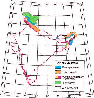
Zone Map
Himalayas of Northwest and Northeast India and the Western Ghats are two regions of high vulnerability and are landslide prone.
Why are Landslides more frequent in the Himalayas than in the Western Ghats?
In the Himalayas, Landslides are very frequent because:
- Heavy snowfall in winter and melting in summer induces debris flow, which is carried in large quantity by numerous streams and rivers – which results in increases chances of Landslides.
- Himalayas are made of sedimentary rocks which can easily be eroded – hence, erosions contribute to more landslides.
- Drifting of Indian plate causes frequent earthquakes and resultant instability in the region.
- Man-made activities like grazing, construction and cultivation abet soil erosion and risks of landslides.
- Himalayas not yet reached its isostatic equilibrium which destabilizes the slopes causing landslides.
- Diurnal changes of temperature are much more in northern India than in southern slopes – weakening the rocks and increasing mass wasting and erosion.
In the Wester Ghats, Landslides are comparatively less frequent because:
- Western Ghats are eroded, denuded, aged, mature, worn out by exogenic forces and have a much lower height – hence, occurrence of Landslides is lesser.
- The Western Ghats are on more stable part of Indian plate, hence, there is a lesser occurrence of earthquakes and landslides.
- While steep slope on western side with high rainfall creates idea condition for landslide but gentle eastern slope with low rainfall and rivers in senile stage, counters the condition.
- Moving of Indian plates doesn’t affect the Western Ghats much (as they are old block mountains), hence the reduced number of landslides.
- Small & swift flowing streams of western side and big matured rivers on eastern side (like Krishna, Godavari, etc) cannot carry large amount of debris.


