Content
- India at World Border Security Congress 2026
- River Basin Management (RBM) Scheme
India at World Border Security Congress 2026
Context: Why in News?
- Venue & Date: Vienna, Austria; April 14–16, 2026, under the World Border Security Congress 2026 platform.
- Representation: Three-member Indian delegation led by Additional Director General Anand Prakash Badola (Indian Coast Guard).
- Focus: India showcased its leadership in maritime security and presented best practices in safeguarding its maritime boundaries, reflecting the nation’s focus on building robust and resilient maritime governance
Relevance
GS III (Internal Security)
- Coastal security → Navy (outer) + ICG (mid) + Coastal Police (inner) layered defence
- Maritime Domain Awareness (MDA) → NC3I (51 nodes), Coastal Radar Chain, IFC-IOR (50+ partners)
- Non-traditional threats → trafficking, drug smuggling, port cyber vulnerabilities
- Economic security → ~95% trade (volume) via sea
Practice Questions
- “Maritime security is central to India’s internal security paradigm.” Examine with reference to coastal architecture and MDA.(250 Words)
Static Background: Maritime Security Essentials
- Geography: India has a coastline of ~11,098 km and an Exclusive Economic Zone (EEZ) of ~2.37 million sq km, giving it a vast maritime jurisdiction.
- Economic Stakes: Over 95% of India’s trade (by volume) and ~68% (by value) moves via sea routes, making maritime stability critical.
- Legal Pillar: United Nations Convention on the Law of the Sea acts as the “Constitution of the Oceans” governing maritime rights.
- Institutional Framework:
- Indian Navy → defence & blue-water operations
- Indian Coast Guard → coastal security, law enforcement, SAR
Integrated Coastal Security Architecture (3-Tier Model)
- Outer Tier: Indian Navy → beyond 200 nm (High Seas), strategic and deterrence operations
- Intermediate Tier: Indian Coast Guard → 12–200 nm (EEZ), surveillance and enforcement
- Inner Tier: Coastal Police → up to 12 nm (Territorial Waters), shallow-water patrolling and local intelligence
Technological Systems
- NC3I Network (National Command Control Communication and Intelligence):
- Integrates 51 nodes for seamless maritime information sharing and real-time response coordination.
- Coastal Radar Chain:
- Network of static sensors providing real-time coastal surveillance picture across India’s coastline.
- IFC-IOR (Information Fusion Centre–Indian Ocean Region):
- Located in Gurugram, enables Maritime Domain Awareness (MDA) and collaborates with 50+ partner countries.
What is the World Border Security Congress?
- Nature: Independent, premier global platform (est. 2012) for border management professionals across maritime, land, and aviation domains.
- Objective: To deliberate on policy frameworks, implementation challenges, and emerging technologies in border protection.
- Core Focus Areas:
- AI, biometrics, UAVs in surveillance
- Tackling transnational crime networks
- Enhancing interoperability among nations
- 2026 Themes:
- Countering human trafficking and drug smuggling
- Climate change impacts on migration and border stability
- Cyber vulnerabilities in maritime infrastructure (ports, shipping systems)
Prelims Pointers
- Indian Coast Guard (ICG): Functions under Ministry of Defence and is nodal agency for Search and Rescue (SAR) and oil spill response.
- AIS (Automatic Identification System): Mandatory for vessels >300 tonnes; India promoting re-transponders for small fishing vessels to enhance tracking.
- UNCLOS (1982): Defines maritime zones (12 nm, 24 nm, 200 nm) and governs navigation rights and resource sovereignty.
- Operation Sagarbandhu: India’s HADR mission (2025–26) in Sri Lanka, cited as example of maritime cooperation and rapid response capability.
- World Border Security Congress: Not a UN body; functions as a multi-stakeholder global forum involving governments, security agencies, and private industry.
River Basin Management (RBM) Scheme
Context: Why in News?
- Government approved continuation of River Basin Management (RBM) Scheme for 2026–27 to 2030–31 (16th Finance Commission cycle).
- Financial Pivot: Outlay increased to ₹2,183 crore (~71% rise from ₹1,276 crore in 2021–26 phase).
- Nature: 100% Central Sector Scheme under Ministry of Jal Shakti.
- Strategic Shift: Transition from “project-based planning” → “basin-wide governance”, especially in hydro-politically sensitive and remote regions.
Relevance
GS III (Environment + Economy)
- Water security → IWRM framework + SDG 6 alignment
- Resource stress → 4% freshwater, 18% population
- Agriculture → ~80% water use → efficiency & sustainability concerns
- Disaster management → floods, erosion (Assam), droughts
- Tech integration → LiDAR, GIS, hydrological modelling → data-driven governance
GS I (Geography)
- Basin as planning unit → hydrological vs administrative mismatch
- Strategic basins → Indus, Brahmaputra, Teesta → geopolitics + ecology
Practice Questions
- “River basin approach is essential for sustainable water governance.” Critically examine in context of RBM Scheme.(250 Words)
Static Background: Water Governance Essentials
- River Basin Management (RBM) is an integrated framework managing surface water, groundwater, and ecosystems within a hydrological unit (river basin) rather than administrative boundaries.
- India has only ~4% of global freshwater resources but supports ~18% of global population, creating structural water stress.
- ~95% of trade (volume) depends indirectly on water-linked sectors, while agriculture consumes ~80% of freshwater, indicating high demand pressure.
- Major basins like Brahmaputra River, Indus, Teesta, and Barak are critical for flood control, irrigation, hydropower, and transboundary water governance.
- Constitutional context: Water is a State Subject (Entry 17, List II), but inter-state rivers fall under Union regulation (Entry 56, List I), necessitating coordinated basin planning.
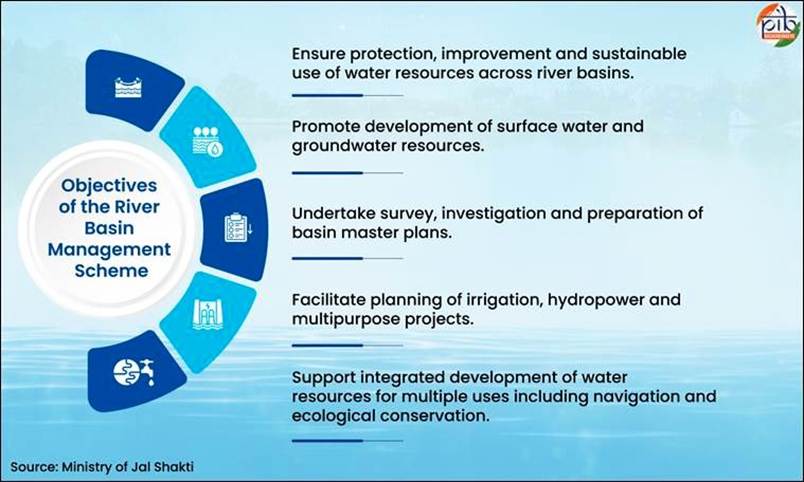
What is the RBM Scheme?
- Nature: A Central Sector Scheme for integrated planning, investigation, and development of water resources at river basin level.
- Core Objective: Promote sustainable water utilisation, support multipurpose projects (irrigation, hydropower, flood control), and enable scientific basin governance.
- Duration & Funding: 2026–31 period, fully funded with ₹2,183 crore, reflecting increased priority to water security planning.
- Functional Scope:
- Preparation of River Basin Master Plans
- Survey, investigation, and DPR preparation
- Planning of inter-basin water transfers (ILR)
- Strategic Orientation: Focus on border basins, ecologically fragile regions, and capacity-deficit states.
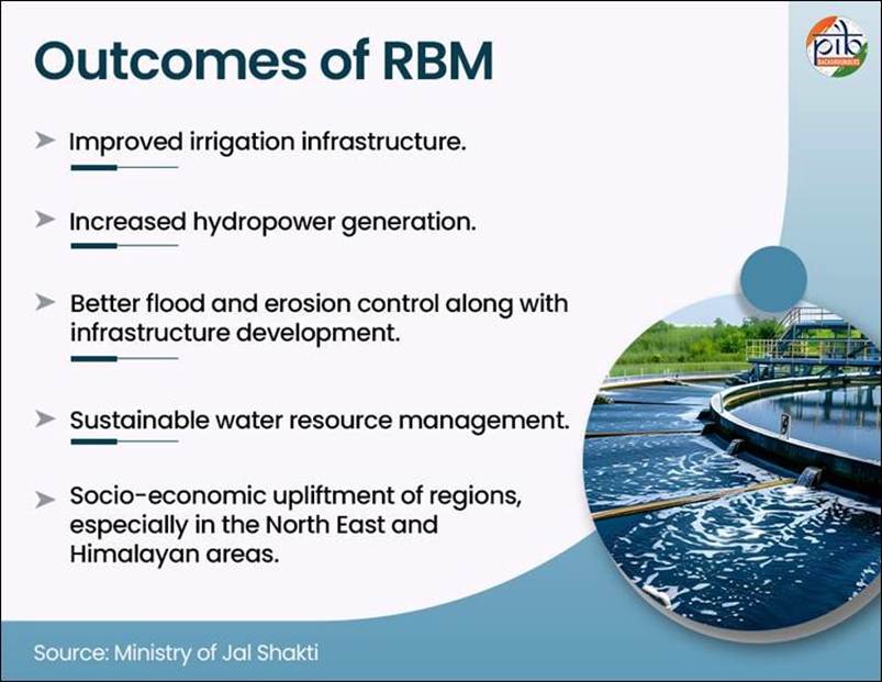
Institutional Trinity (Implementing Agencies)
- Brahmaputra Board: Handles regional basin planning in North East, focusing on flood control, erosion management, and protection of Majuli Island.
- Central Water Commission (CWC): Responsible for technical surveys, hydrological assessments, and Detailed Project Reports (DPRs) in Indus, Teesta, Barak, Brahmaputra basins.
- National Water Development Agency (NWDA): Leads Interlinking of Rivers (ILR) through water balance studies, PFRs, FRs, DPRs, and inter-basin transfer planning.
Geographical & Strategic Priorities
- Border Basin Focus:
- Indus (J&K/Ladakh), Teesta (Sikkim/WB), Brahmaputra & Barak (NER) → crucial for transboundary water diplomacy and national security.
- Capacity Support:
- Targeted assistance to Mizoram, Manipur, Nagaland, Sikkim, J&K, which lack technical and financial capacity for basin-scale planning.
- Vulnerability Mapping:
- Focus on flood-prone and erosion-heavy zones, especially Assam valley, prone to riverbank erosion and seasonal flooding.
Modernising Governance: Technology Stack
- LiDAR & Drone Surveys: Enable high-resolution topographical mapping in Himalayan and remote terrains, improving DPR accuracy.
- GIS & Remote Sensing: Used for real-time monitoring of river morphology, sedimentation, and basin dynamics.
- Hydrological Modelling: Enhances predictive planning for floods, droughts, and water allocation.
- Springshed Management: Focus on micro water sources in hilly regions, marking shift from river-centric to ecosystem-centric management.
Prelims Pointers
- RBM Scheme: A 100% centrally funded Central Sector Scheme under Ministry of Jal Shakti, unlike Centrally Sponsored Schemes (no state share required).
- Financial Outlay: ₹2,183 crore (2026–31) with ~71% increase over previous ₹1,276 crore (2021–26) phase.
- Institutional Mechanism: Implemented via Brahmaputra Board, CWC, and NWDA, forming the core governance architecture.
- NWDA Achievements: Identified 30 river link projects, with 26 feasibility reports and 15 DPRs, including Kosi–Mechi link project.
- Majuli Island: Largest river island protected under RBM-led anti-erosion works in Brahmaputra basin.
- NEHARI Institute: North Eastern Hydraulic & Allied Research Institute, supports capacity building and technical training under RBM framework.


