Why in News ?
- The India Meteorological Department (IMD) has reported two simultaneous cyclonic systems developing on either side of India —
- Cyclone Montha in the Bay of Bengal,
- and a persistent depression in the Arabian Sea.
- Such twin cyclonic formations are rare but indicate a hyperactive North Indian Ocean phase.
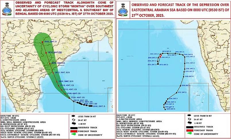
- Cyclone Montha is expected to make landfall near Kakinada (Andhra Pradesh) on October 28, 2025, while the Arabian Sea system is moving towards Gujarat.
Relevance:
- GS-1 (Geography): Tropical cyclones – formation, classification, and regional patterns (Bay of Bengal vs Arabian Sea).
- GS-3 (Environment): Climate change impact on cyclone intensity and frequency (IPCC AR6 linkage).
- GS-3 (Disaster Management): Role of IMD, NDMA, NCRMP, and early warning systems.
Meteorological Context
- Formation dates:
- Bay of Bengal system formed October 24, intensified rapidly into Cyclone Montha by October 26.
- Arabian Sea depression formed on October 22 — has not intensified or dissipated.
- Movement patterns:
- Cyclone Montha: Moving NNW at ~18 km/hr, currently ~520 km ESE of Chennai.
- Arabian Sea depression: Highly erratic track — NW → NE → N → W → S → N again; now drifting towards Gujarat coast.
- Wind speeds (IMD forecast):
- Sustained: 90–100 km/hr
- Gusts: Up to 110 km/hr
- Classified as a Severe Cyclonic Storm (SCS).
- Expected impact:
- Storm surge: ~1 metre above astronomical tide, threatening low-lying areas of coastal Andhra Pradesh and Yanam (Puducherry).
- Rainfall: Very heavy to extremely heavy rainfall over Andhra Pradesh, Odisha, Chhattisgarh, and Telangana.
Technical & Climatic Analysis
- Faster-than-expected intensification due to:
- High sea surface temperature (SST): ~30–31°C in Bay of Bengal.
- Strong convection and latent heat release in the mid–upper troposphere.
- Low vertical wind shear enabling organized circulation.
- Twin cyclones phenomenon:
- Known as “Basin Dipole Activity”, where simultaneous low-pressure systems form in both the Bay of Bengal and Arabian Sea.
- Typically arises from enhanced Madden–Julian Oscillation (MJO) activity and Indian Ocean warm pool anomalies.
- Climatic context:
- October–November is the post-monsoon cyclone season, contributing 25–30% of annual cyclonic activity in the North Indian Ocean.
- Bay of Bengal accounts for ~80% of cyclones in this basin; Arabian Sea for the remaining 20%.
Comparative Dynamics
| Feature | Cyclone Montha (Bay of Bengal) | Arabian Sea Depression |
| Formation Date | October 24, 2025 | October 22, 2025 |
| Status | Severe Cyclonic Storm (SCS) | Depression |
| Wind Speed | 90–110 km/hr | 30–40 km/hr |
| Landfall Forecast | Near Kakinada (Andhra Pradesh) | Moving towards Gujarat coast |
| SST Influence | 30–31°C | 29–30°C |
| IMD Alert | Red alert for East Coast | No official alert yet |
Environmental & Socioeconomic Implications
- Risk to coastal infrastructure: High wind + storm surge → potential damage to ports, power lines, and fishing harbours.
- Agricultural impact: Possible crop loss in Andhra Pradesh, Odisha, and Telangana, especially in paddy and horticulture zones.
- Marine hazards: Disruption of shipping routes in both Bay of Bengal and Arabian Sea.
- Humanitarian preparedness: NDRF and state disaster management authorities placed on high alert.
Scientific and Policy Significance
- IMD’s Early Warning System:
- Use of INSAT-3D/3DR, GFS, and ECMWF data for real-time tracking.
- Demonstrates improved predictive accuracy under the National Monsoon Mission.
- Climate linkage:
- Strengthening evidence of warming-induced cyclone intensification in the North Indian Ocean.
- Aligns with IPCC AR6 finding — increase in rapid intensification events since 1990s.
- Policy relevance:
- Supports India’s National Cyclone Risk Mitigation Project (NCRMP) under NDMA.
- Reinforces need for urban flood resilience and coastal infrastructure hardening under PM Gati Shakti and Blue Economy Vision 2047.
Conclusion
- The twin cyclonic systems — Montha in the Bay of Bengal and the Arabian Sea depression — represent a critical climate–weather intersection.While Cyclone Montha is a near-term threat to the east coast, the western depression underscores persistent oceanic heat anomalies and shifting monsoonal dynamics.
- This episode highlights the growing complexity of India’s cyclonic climatology, demanding integrated early-warning systems, coastal adaptation measures, and regional cooperation in disaster risk reduction.
Static Revision
Definition and Classification
- Cyclone: Rapidly rotating storm system characterized by a low-pressure center, strong winds, and heavy rainfall.
- Types (based on wind speed – IMD classification):
| Wind Speed (km/hr) | Example | |
| Low Pressure Area | <31 | Monsoon lows |
| Depression (D) | 31–49 | Monsoon depressions |
| Deep Depression (DD) | 50–61 | Pre-cyclone phase |
| Cyclonic Storm (CS) | 62–88 | Cyclone Sitrang (2022) |
| Severe Cyclonic Storm (SCS) | 89–117 | Cyclone Montha (2025) |
| Very Severe Cyclonic Storm (VSCS) | 118–165 | Cyclone Tauktae (2021) |
| Extremely Severe Cyclonic Storm (ESCS) | 166–220 | Cyclone Amphan (2020) |
| Super Cyclonic Storm (SuCS) | ≥221 | Odisha Super Cyclone (1999) |
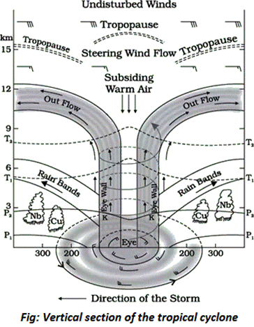
Structure of a Tropical Cyclone
- Eye: Calm center with descending air and clear skies.
- Eye Wall: Ring of towering cumulonimbus clouds with strongest winds and rainfall.
- Spiral Rainbands: Bands of clouds and thunderstorms spiraling towards the center.
- Energy Source: Latent heat released by condensation over warm ocean waters (≥26.5°C).
Conditions Favourable for Cyclone Formation
- Warm sea surface temperature (≥26.5°C) up to 60 m depth.
- Coriolis force (absent near Equator → cyclones form between 5°–15° N/S).
- High humidity in the lower–mid troposphere.
- Atmospheric instability promoting convection.
- Low vertical wind shear (<10 m/s).
- Pre-existing low-pressure disturbance or intertropical convergence zone (ITCZ) perturbation.
North Indian Ocean (NIO) Cyclone Basin
- Extent: Between 45°E–100°E longitude, including Bay of Bengal (BoB) and Arabian Sea (AS).
- Seasonal Peaks:
- Pre-monsoon: April–June
- Post-monsoon: October–December (more intense)
- Cyclone frequency (IMD average 1891–2020):
- Bay of Bengal: ~5.5 cyclones/year (~80% of total NIO cyclones)
- Arabian Sea: ~1.5 cyclones/year (~20%)
- Recent trend: Frequency in Arabian Sea increasing due to rapid warming; BoB remains dominant in intensity.
Reasons for Bay of Bengal’s Higher Cyclonic Activity
- Warmer SSTs (average 29–31°C).
- Abundant moisture from rivers and monsoon outflow.
- Shallow sea and high latent heat flux.
- Remnant low-pressure systems from Pacific crossing over via Myanmar.
- Weak vertical wind shear during transition seasons.
- Favorable Madden–Julian Oscillation (MJO) phase more frequent.
Arabian Sea Cyclones — Emerging Concern
- Earlier: Cooler waters and stronger wind shear inhibited cyclones.
- Now (post-2000): Warming trend of +1.2°C/decade; conducive for more VSCS (Tauktae, Mekunu, Vayu, Biparjoy).
- Driven by:
- Indian Ocean Dipole (IOD) phases.
- Anthropogenic warming of Western Indian Ocean.
- Reduced aerosol loading increasing solar absorption.
Naming of Cyclones
- Initiated in 2004 by WMO/ESCAP Panel on Tropical Cyclones.
- Member countries: 13 (India, Bangladesh, Pakistan, Myanmar, Thailand, Sri Lanka, Maldives, Oman, UAE, Yemen, Qatar, Iran, Saudi Arabia).
- Names are pre-determined and rotated in lists — next name after Montha will be from Myanmar’s contribution.
Indian Meteorological Institutions & Monitoring
- Nodal Agency: India Meteorological Department (IMD) – Regional Specialized Meteorological Centre (RSMC), New Delhi.
- Other key institutions:
- National Centre for Medium Range Weather Forecasting (NCMRWF)
- Indian National Centre for Ocean Information Services (INCOIS)
- National Disaster Management Authority (NDMA)
- National Cyclone Risk Mitigation Project (NCRMP)
- Technology used: INSAT-3D/3DR, Doppler weather radars, GFS, ECMWF, and satellite-based SST data.


