Content
- Invasive mosquito species threatens India’s 2030 malaria elimination goal
- CRIF–SIDBI Small Business Spotlight Report — MSME Credit Resilience
- The 260-MW Dulhasti Stage-II hydropower project on the Chenab
- ₹500-Crore Development Push for Rakhigarhi as a Global Heritage & Mega-Harappan Urban Site
- Tiger State status after 33 years
- US strike on Islamic State militants in Nigeria
Invasive mosquito species threatens India’s 2030 malaria elimination goal
Why is it in News?
- The Health Ministry’s “Malaria Elimination Technical Report 2025” warns that the invasive mosquito species Anopheles stephensi is rapidly spreading in Indian cities (Delhi, Ahmedabad, Chennai, Bengaluru, etc.).
- This trend is intensifying urban malaria transmission, threatening:
- Zero indigenous cases by 2027 (intermediate goal)
- Malaria-free India by 2030 (national + WHO Global Technical Strategy target)
Relevance
- GS-3 | Science, Environment & Technology in Health
- Epidemiology, invasive species ecology, insecticide resistance
- Urban planning → water, sanitation, and environmental determinants of health
- Evidence-based policy, operational research in disease elimination
Trend & Key Data
- Cases reduced: 11.7 lakh (2015) → ~2.27 lakh (2024)
- Deaths reduced: ~78% decline (2015–2024)
- Burden now localized in pockets — Odisha, Tripura, Mizoram; border districts (Myanmar–Bangladesh corridor)
- Urban transmission rising due to An. stephensi expansion
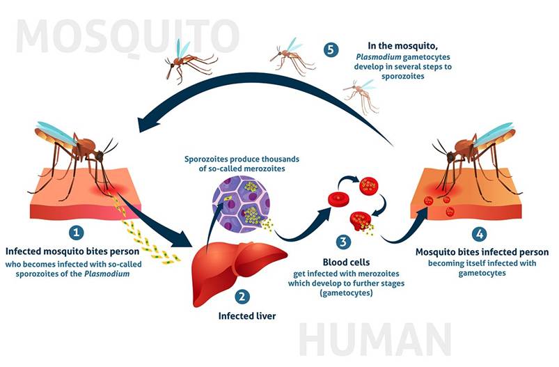
Basics — Malaria: Pathogen, Vector & Transmission
- Parasites: Plasmodium falciparum, P. vivax (major in India)
- Vector: Female Anopheles mosquito
- Transmission cycle: Human–mosquito–human (requires stagnant breeding sites + susceptible population)
- Traditional ecology: Historically rural + forest regions
What Makes Anopheles stephensi Different?
- Urban-adapted invasive species (earlier endemic to West Asia)
- Breeds in artificial containers — tanks, overhead reservoirs, construction sites, tyres, rooftop drums
- Thrives in informal settlements & high-density localities
- Highly efficient transmitter of P. falciparum + P. vivax
- Spreads through migration, trade, construction activity
Converts malaria from a rural problem into a city-driven public-health challenge.
Why Urban Malaria is Harder to Control
- Container breeding → diffuse, scattered hotspots
- Fragmented urban governance → municipal–private–informal gaps
- Mobile migrant workforce → silent transmission chains
- Asymptomatic infections → low detection
- Weak private-sector reporting → surveillance blind spots
- Construction boom + water storage dependence → perpetual breeding sources
Report’s Key Findings
- Residual high-burden pockets persist in:
- Tribal & forest belts
- Border districts (Myanmar & Bangladesh spillover)
- Migrant & mobile settlements
- Operational challenges:
- Limited entomological capacity
- Drug & insecticide resistance emerging
- Stock-out risks — diagnostics & ACTs
- Gaps in remote / tribal service delivery
- Top priorities identified:
- Strengthen surveillance
- Enhance vector monitoring
- Secure supply-chain reliability
- Expand operational research
Cross-Border Dimensions (Internal Security–Health Link)
- Spillover transmission from Myanmar & Bangladesh
- Human migration + porous borders → imported cases
- Requires joint surveillance, screening & data sharing
Policy Targets
- Zero indigenous cases by 2027 (India’s intermediate milestone)
- Elimination by 2030 (aligned with WHO strategy)
- Current risk: Urban malaria threatens trajectory
Way Forward — Strategy Priorities
- City-specific vector control models (not rural-centric)
- Source reduction campaigns in construction + slum clusters
- Integration of:
- Housing & urban development bodies
- Municipal corporations
- Private hospitals & labs (mandatory reporting)
- GIS-based hotspot surveillance
- Larvivorous fish + biological control in water tanks
- Insecticide-resistance mapping
- Community participation & behavioural change
- Migrant-focused screening + mobile clinics
CRIF–SIDBI Small Business Spotlight Report — MSME Credit Resilience
Why is it in News?
- The CRIF–SIDBI Small Business Spotlight Report finds that India’s small-business credit ecosystem remains resilient and expanding, supported by policy measures and formalisation.
- The report analyses enterprises with credit exposure ≤ ₹5 crore.
Relevance
- GS-3 | Economy — MSMEs, Financial Inclusion, Credit Markets
- MSME credit deepening, formalisation, NTC borrowers, LAP trends
- Role of private banks, PSBs, NBFCs, co-lending
- Cash-flow lending, ALT-data underwriting, digital public infrastructure
Key Data & Trends
- Aggregate small-business credit exposure: ₹46 lakh crore
- Growth: +16.2% YoY
- Active loan accounts: 7.3 crore
- Growth: +11.8% YoY
- Asset quality: Healthy / stable (no major deterioration reported)
- Drivers:
- Policy support + government MSME credit schemes
- Wider lender participation
- Gradual rise in formalisation
What Counts as “Small-Business Credit”?
- Firms / entities with banking or NBFC credit exposure up to ₹5 crore
- Typical borrower categories:
- Sole proprietors
- Micro & small enterprises
- Early-stage formalising firms
Structural Profile of Borrowers
- Sole proprietors dominate
- ~80% of total credit
- ~90% of total borrowers
- Fastest-growing segment:
- Sole proprietors with entity presence
- ~20% YoY growth, largely via Loans Against Property (LAP)
Formalisation Signal
- 23.3% borrowers = New-to-Credit (NTC)
- 12% borrowers = New-to-Enterprise borrowing
- Indicates:
- Entry of previously informal units into the formal credit system
- Expansion beyond household / personal borrowing to business-linked finance
Lender Landscape — Who is Driving Credit?
- Private banks → Lead enterprise lending
- Public sector banks → Close second
- NBFCs → Steadily increasing share, particularly in LAP and micro-enterprise segments
- Working capital loans:
- ~57% of outstanding credit
- Reflects business continuity + cash-flow based financing
What Makes the Ecosystem “Resilient”?
- Portfolio growth without asset-quality stress
- Credit diversification across lenders
- Supportive policy pipeline, including:
- Emergency Credit Line Guarantee Scheme (ECLGS)
- Credit Guarantee Trust for Micro & Small Enterprises (CGTMSE)
- Digital Public Infrastructure–based underwriting (Aadhaar–GST–UPI data trails)
Regional / Sectoral Dynamics
- Growth stronger in:
- Urban & peri-urban clusters
- Retail trade, services, and micro-manufacturing
- Vulnerabilities persist in:
- Construction-linked and low-margin traditional sectors (credit-risk sensitivity remains)
Opportunities Emerging
- Expansion of cash-flow based lending
- Rise of ALT-data credit scoring through GST/e-invoices
- NBFC–bank co-lending deepening MSME reach
- Improved credit inclusion for first-time enterprise borrowers
Risks & Structural Challenges
- Over-reliance on LAP among micro-entrepreneurs
- Uneven access across low-income / rural women-led enterprises
- Potential stress if interest-rate or cash-flow shocks occur
- Need for stronger credit-information reporting among NBFCs & micro-lenders
Policy Significance
- Supports goals of:
- MSME competitiveness + job intensity
- Formalisation of the informal sector
- Strengthening financial inclusion + credit deepening
- Aligns with:
- National Credit Framework for MSMEs
- Digital lending + data-driven underwriting reforms
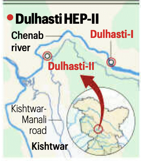
The 260-MW Dulhasti Stage-II hydropower project on the Chenab
Why is it in News?
- The Environment Ministry’s Expert Appraisal Committee (EAC) has recommended environmental clearance for the 260-MW Dulhasti Stage-II hydropower project on the Chenab River in Kishtwar district, Jammu & Kashmir.
- The decision comes amid India’s move to fast-track hydropower projects in the Indus basin, while the Indus Waters Treaty (IWT) stands in abeyance following Pakistan’s continued objections and the April 2024 Poonch terror attack.
- The project is part of a wider strategic push to enhance India’s hydropower utilisation and river-control leverage on western rivers allocated to Pakistan under IWT.
Relevance
- GS-2 | International Relations
- Indus Waters Treaty (1960) — water-sharing, strategic signalling
- India–Pakistan dispute mechanisms, treaty-based rights utilisation
- GS-3 | Environment, Energy & Infrastructure
- Hydropower, run-of-river project design, ecological flows
- Himalayan ecology, cumulative impact & basin-level governance
- Renewable / low-carbon transition & energy security
Key Project Details
- Project: Dulhasti Stage-II (Run-of-River)
- Capacity: 260 MW
- Developer: NHPC Ltd
- Estimated Cost: ₹3,277.45 crore
- Location: Downstream of Dulhasti-I, on Chenab; uses Marusudar tributary water diversion
- Water Transfer Plan:
- Surplus flows from Marusudar diverted through Pakal Dul powerhouse into Dulhasti reservoir
- ~25 km stretch downstream to face hydrological & ecological alteration
- Clearance Conditions:
- River-corridor conservation strategy
- Biodiversity safeguards
- Monitoring of sediment & flow regimes
- Cumulative basin-level impact assessment
Indus Waters Treaty — Basics
- Signed (1960) between India & Pakistan with World Bank mediation.
- River allocation:
- Eastern rivers (Ravi, Beas, Sutlej) → India
- Western rivers (Indus, Jhelum, Chenab) → Pakistan (with limited non-consumptive use permitted to India — hydropower, navigation, flood control).
- India allowed run-of-river hydel projects subject to design constraints (pondage limits, spillway rules).
Why the Current Shift?
- After Pakistan’s persistent objections and lawfare-style litigation over Kishanganga & Ratle projects:
- India declared the IWT “in abeyance” in 2024, citing unilateral misuse of dispute-resolution mechanisms.
Chenab Basin — Ongoing / Planned Hydropower
- Operational / advanced projects (indicative):
- 390-MW Dulhasti-I (NHPC)
- 850-MW Ratle (under construction)
- 624-MW Kiru
- 540-MW Kwar
- 690-MW Sawalkote (planned)
- Basin strategy: Cascade hydropower development + storage optimisation.
Environmental & Social Considerations
- Risks flagged:
- Flow regime alteration in Marusudar downstream stretches
- Sediment disruption, aquatic ecology changes
- Cumulative impacts of multiple hydel projects
- Mitigation mandates (EAC):
- Basin-wide hydrological monitoring
- Ecological flow (e-flow) assurance
- Biodiversity and catchment-area treatment
Strategic Significance
- Enhances energy security + peaking power capacity in J&K.
- Strengthens India’s lawful utilisation of IWT-permitted rights.
- Acts as geo-strategic signalling vis-à-vis Pakistan’s objections.
- Supports hydropower-led low-carbon transition in Himalayan basins.
Challenges & Critiques
- Environmental fragility of Himalayan river systems
- Glacial-fed river variability & climate risk
- Cumulative impact governance gaps
- Seismic vulnerability + landslip risk zones
- Need for transparent data-sharing & local livelihood safeguards
₹500-Crore Development Push for Rakhigarhi as a Global Heritage & Mega-Harappan Urban Site
Why is it in News?
- The Haryana CM announced that the Union Budget has allocated ₹500 crore for the development of Rakhigarhi as a global heritage site.
- Objective:
- Develop the site as a world-class archaeological and tourism hub
- Strengthen global recognition of the Harappan (Indus Valley Civilization) site
- Work toward UNESCO World Heritage List nomination.
Relevance
- GS-1 | Ancient History & Culture
- Harappan urbanism, material culture, subsistence patterns
- Ghaggar–Hakra palaeo-channel & regional Harappan geography
- GS-2 | Governance & Culture Policy
- Heritage conservation, tourism-linked development
- UNESCO World Heritage nomination & soft power
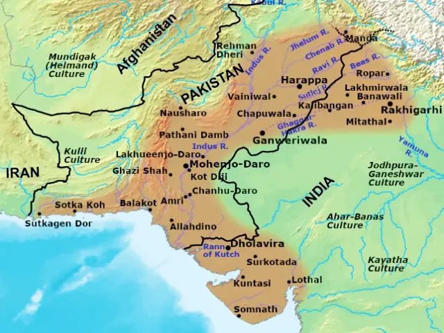
Rakhigarhi — Basics
- Location: Hisar district, Haryana (Ghaggar–Hakra palaeo-channel region)
- Civilization Layer: Indus Valley / Harappan Civilization
- Cultural Phases Identified:
- Pre-Harappan / Early Harappan (c. 3300–2600 BCE)
- Mature Harappan (c. 2600–1900 BCE)
- Spread: Largest excavated Harappan site in India; among the largest in the subcontinent.
Why Rakhigarhi is Considered a Mega-Harappan Urban Centre ?
- Site area: ~350 hectares (cluster of 7 mounds — RGR-1 to RGR-7)
- Urban characteristics found:
- Planned streets, drainage & brick structures
- Craft-production zones (beads, copper, shell, ceramics)
- Granaries & storage systems
- Social stratification indicators
- Inter-regional linkages: Trade evidence with Sindh, Gujarat, and western Rajasthan.
Key Archaeological Findings
- Artefacts & material culture:
- Painted pottery, bangles, terracotta figurines
- Copper tools, beads, lapis lazuli, carnelian
- Seals & weights indicating urban economic organisation
- Burials discovered:
- Brick-lined graves, pottery offerings, skeletal remains
- Evidence of ritual behaviour & social hierarchy
- DNA & bio-anthropological findings (IIT-Kharagpur / ASI collaborations):
- Indicate local population continuity, limited Steppe linkage in Mature Harappan urban phases
- Subsistence indicators:
- Evidence of mixed agro-pastoral economy (millets, wheat–barley, cattle-based economy).
Government Development Plan
- ₹500 crore allocation (Union Budget)
- Focus areas:
- Site conservation + scientific preservation
- Site museum, interpretation centre, visitor amenities
- Tourism infrastructure & connectivity
- Community-linked livelihood ecosystem
- State govt. goal:
- Position Rakhigarhi on national & international tourism map
- Prepare dossier for UNESCO World Heritage nomination.
Strategic & Academic Relevance
- Strengthens India’s narrative on:
- Indus Civilization geography beyond Pakistan’s Mohenjo-Daro & Harappa
- Ghaggar–Hakra river system debates
- Reinforces Haryana–Rajasthan–Punjab belt as a Harappan cultural core zone.
Challenges & Concerns
- Unplanned urbanisation & encroachments near mounds
- Need for:
- Scientific excavation protocols
- Erosion & waterlogging protection
- Long-term site management plan
- Balancing tourism development vs archaeological integrity.
Prelims Pointers
- Rakhigarhi → Largest Harappan site in India, located in Haryana.
- Situated on Ghaggar–Hakra palaeo-river system.
- Evidence of Early + Mature Harappan urbanism, craft specialisation, organised drainage.
- Cluster of 7 mounds (RGR-1 to RGR-7).
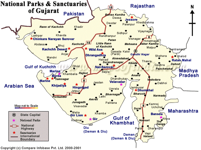
‘Tiger State’ status after 33 years
Why is it in News?
- The National Tiger Conservation Authority (NTCA) has confirmed the presence of a tiger in the Ratanmahal Wildlife Sanctuary (Central Gujarat) during the 2024-25 National Tiger Census exercise.
- Based on this confirmation, Gujarat has regained ‘Tiger State’ status after 33 years.
- The last recorded tiger presence in Gujarat was in 1992, after which the State was excluded from the Tiger Census.
Relevance
- GS-3 | Environment, Biodiversity & Conservation
- NTCA, Tiger Census, species recolonisation & corridors
- Predator ecology & prey-base restoration
- Landscape-level conservation models
- GS-1 | Geography of Wildlife Landscapes
- Ratanmahal Sanctuary ecology, semi-arid forests
- Western Indian wildlife corridors
Key Facts & Data
- Evidence of tiger presence
- Pugmarks recorded: February 23 (Kanjeta Range, Ratanmahal Sanctuary)
- Camera-trap confirmation: February 22, 2:40 AM (Tiger photo-captured)
- NTCA study team validated presence and recommended ecosystem strengthening measures.
- Gujarat now has all three big cats simultaneously:
- Lion (Asiatic Lion — Gir & Greater Gir)
- Leopard
- Tiger
- → Only State in India to host all three together
Historical Context — Why Gujarat Lost the Status Earlier ?
- 1989 Tiger Census → pugmarks of a tiger recorded in Mahisagar region
- 1992 Tiger Census → tiger population failed to survive → Gujarat removed from Tiger State list
- After >3 decades, tiger presence has again been verified.
About Ratanmahal Wildlife Sanctuary
- Location: Dahod–Mahisagar landscape, Central Gujarat
- Habitat: Dry deciduous forests, rugged hill slopes, ravines
- Core fauna:
- Sloth bear (major population)
- Herbivores: bluebull, sambar, spotted deer
- Prey-base restoration programs underway
Conservation Measures Linked to Tiger Re-entry
- Habitat enrichment
- Increased availability of water & prey base
- Release of antelope & spotted deer during monsoon
- Fire & grazing control, corridor protection
- Camera-trap network expanded
- Officials to receive tiger conservation & captive-breeding training
Strategic Significance
- Strengthens Western Indian landscape conservation
- Demonstrates:
- Landscape-level species movement
- Importance of corridor-based conservation
- Enhances Gujarat’s biodiversity tourism & conservation profile
- Complements:
- Project Tiger (NTCA)
- Lion landscape conservation
- Leopard coexistence programmes
Challenges Ahead
- Ratanmahal is not a traditional tiger habitat → requires:
- Long-term prey-base stabilisation
- Human-wildlife conflict management
- Strict poaching & encroachment control
- Need to maintain corridors with MP forests
- Avoid over-tourism & habitat fragmentation
Prelims Pointers
- Ratanmahal Wildlife Sanctuary → Gujarat; known for sloth bear population.
- Gujarat is now the only Indian state with Lion-Tiger-Leopard together.
- NTCA = Statutory body under Wildlife (Protection) Act, 1972 (as amended).
US strike on Islamic State militants in Nigeria
Why is it in News?
- The United States carried out an air strike in northwest Nigeria (Sokoto State) at the request of the Nigerian government, targeting Islamic State (IS) militants.
- Operation conducted through US Africa Command (AFRICOM) in coordination with Nigerian security agencies.
- The strike reportedly killed 15 militants linked to attacks on Christian communities and civilians in the region.
Relevance
- GS-2 | International Relations & Global Security
- US–Nigeria counter-terror cooperation, AFRICOM role
- West Africa → Sahel terrorism corridor dynamics
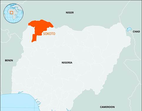
Places in News — Map-Linked Facts
- Sokoto State
- Located in North-West Nigeria
- Borders Niger Republic
- Part of the Sahel-Savannah transition zone
- Increasing militant movement from ISIS-West Africa & Sahel spillover regions
- Nearby regions referenced:
- Benin (to the west)
- Niger (to the north)
- Cameroon (to the east)
- Gulf of Guinea (south-west maritime region)
- Region forms part of the West African instability arc
(Sahel → Lake Chad Basin → Gulf of Guinea coastal states)
Implications for India
- Energy security risks (India imports crude from Nigeria / Gulf of Guinea)
- Possible impact on:
- Maritime security, piracy, and insurgency spillovers
- Adds complexity to:
- Indian diaspora safety in West Africa
- UN peacekeeping & counter-terror cooperation
Prelims — Places & Bodies Pointers
- Sokoto State → North-West Nigeria, near Niger border
- AFRICOM → US military command for Africa-region operations
- Gulf of Guinea → West African maritime region
(oil shipping lanes, piracy hotspot)


