Content
- What does the SHANTI Bill change?
- What remote-sensing reveals about plants, forests, and minerals from space
- Police in States step up social media monitoring
- Mexico’s Popocatépetl volcano — first 3D interior imaging
- Places in News(Colombia, Mexico, Cuba, Greenland)
What does the SHANTI Bill change?
Why is it in News?
- Parliament has passed the Sustainable Harnessing and Advancement of Nuclear Energy in India (SHANTI) Bill.
- It opens India’s nuclear power sector to private and foreign participation — ending the exclusive State-run regime since 1956.
- Opposition demanded Select Committee review, citing concerns about:
- diluted liability
- safety and transparency risks
- weakening RTI and labour safeguards
- The government argues the law is essential for energy security, baseload power, clean energy, and nuclear expansion.
Relevance
GS-2 | Polity & Governance
- Public sector reforms, regulatory institutions, accountability
- Parliamentary oversight, transparency, RTI, labour safeguards
- State vs market role in strategic sectors
GS-3 | Economy / Infrastructure / Energy
- Nuclear energy policy, investment models, PPP in strategic sectors
- Energy security, baseload power, Net-Zero strategy
- Technology partnerships & FDI policy constraints
The Basics — Nuclear Governance Before SHANTI
- Sector governed by:
- Atomic Energy Act, 1962
- Civil Liability for Nuclear Damage (CLND) Act, 2010
- Nuclear operations were monopolised by NPCIL.
- Private/foreign role restricted due to:
- strict supplier liability
- high legal risk exposure
- Result → capital shortage, slow capacity addition, stalled global partnerships.
What the SHANTI Bill Does ? — Core Provisions
- Opens nuclear projects to private Indian companies (licences to own, build, operate plants)
- Allows foreign supplier participation (indirectly, via JV / supply chains)
- Government to retain 51% control over strategic & sensitive functions:
- nuclear fuel cycle / reprocessing
- heavy water & enrichment
- radioactive waste & spent fuel
- radiation safety & emergency systems
- regulatory oversight
Ends NPCIL’s monopoly
- Enables PPP-style model
- Private role in:
- equipment & fuel fabrication
- reactor construction & operation
- R&D and advanced technologies
Supports deployment of:
- Small Modular Reactors (SMRs)
- Advanced Pressurised Water Reactors
- Indigenous reactor designs
Policy link: ₹20,000 crore allocation announced for SMRs & advanced reactors under the Nuclear Energy Mission.
Regulatory Architecture — Role of AERB
- Atomic Energy Regulatory Board (AERB) given statutory status
→ now answerable to Parliament, not only the executive - Mandate:
- nuclear & radiation safety
- licensing & inspection
- emergency preparedness
- quality & industrial safety compliance (Factories Act linkage)
Criticism flagged:
Concentration of regulatory power in one body → demand for independent nuclear safety commission.
What Has Changed on Liability?
Earlier regime (CLND Act, 2010)
- Operators could recover liability from suppliers for:
- defective parts, design faults, wilful acts
- Supplier liability discouraged foreign entry.
Under SHANTI — Predictable, Capped Liability
| Plant Type | Capacity | Operator Liability Cap |
| Large plants | ~3600 MW | ₹3,000 crore |
| Medium plants | 1500–3600 MW | ₹1,500 crore |
| SMRs | ~150 MW | ₹100 crore |
| Penalty for violations | — | ₹1 crore (cap) |
- Beyond the cap → Union Government pays, supported by a Nuclear Liability Fund.
- Supplier liability removed completely.
Government reasoning:
Predictable liability → lowers risk → attracts investment & technology inflow.
Opposition argument:
Shifts burden to State & society → weakens polluter-pays principle.
Comparative data point
- Fukushima damages ≈ 700× higher than SHANTI’s proposed liability cap
→ highlights catastrophic-risk underestimation concern.
Safeguards Retained
- No automatic FDI permission — route remains case-specific & regulated
- AERB authorisation required for:
- possession, production, disposal of nuclear/radiation materials
- establishing & operating facilities
- Government retains:
- fuel reprocessing, enrichment, heavy-water production
- high-level waste management
- Nuclear Liability Fund created for accident compensation.
Transparency, Labour & Safety — Contested Clauses
Concerns Raised
- Section 39 — overrides RTI Act review & appeal mechanisms
→ restricts public access to safety & operational information. - Section 42 — exempts nuclear workers from general labour safety laws
→ unions term it “draconian”. - No statutory requirements for:
- public hearings
- EIA disclosure
- community consent
- periodic safety reporting / parliamentary review
Government’s Position — Rationale & Benefits
- Strengthen energy security & baseload capacity
- Reduce dependence on:
- coal & fossil imports
- single-country nuclear partnerships
- Support:
- Net-Zero 2070
- clean energy & grid stability
- Reactivate stalled deals with U.S., France, Japan
- Encourage technology diversity + investment inflow
Why Nuclear Energy Matters for India ?
- Renewables intermittency + storage costs
- India still relies heavily on coal for power
- Nuclear provides:
- 24×7 baseload
- very low lifecycle emissions
- long-term cost stability
Current nuclear profile
- 25 reactors across 7 plants
- 21 PHWRs + 4 LWRs
- Installed nuclear capacity ~7 GW (≈ 3% of total electricity mix)
- Long-term strategy built around thorium cycle & fast breeder reactors
Opposition’s Key Criticisms
- Accountability diluted, private profit + public risk
- Liability caps too low, supplier walks free
- RTI override weakens public oversight
- Labour protections diluted
- Vendor-driven push despite indigenous thorium tech capability
- Lack of safety-democracy mechanisms (consultation, EIA transparency)
- Global comparator:
- France keeps nuclear under full state control
- Labels the Bill as:
- pro-corporate / pro-oligarch
- risking public safety & environment
Strategic & Governance Implications
- Marks a paradigm shift: State-monopoly → regulated PPP model
- May accelerate:
- capacity addition
- financing & technology partnerships
- Raises structural questions:
- Are liability caps socially optimal?
- Is independent nuclear safety regulation adequate?
- Can transparency be ensured without weakening security?
Takeaways
- SHANTI Bill = Liberalisation of nuclear sector + capped operator liability + removal of supplier liability + PPP-driven expansion under State oversight.
- Balances investment predictability vs public safety & accountability risks.
- Core tension = Energy security + clean baseload ↔ liability, transparency, labour & safety concerns.
What remote-sensing reveals about plants, forests, and minerals from space
Why is it in News?
- Remote-sensing technologies — satellites, drones, hyperspectral sensors, SAR radars, and gravity-mapping missions — are increasingly being used for:
- resource mapping (minerals, groundwater, hydrocarbons)
- forest health & biomass estimation
- flood mapping & water monitoring
- climate change research & environmental protection
- Growing relevance due to:
- India’s push toward climate resilience, water security, precision agriculture, and mineral exploration
- expansion of ISRO-led EO missions, NISAR, Bhuwan, NRSC programmes
Remote-sensing has moved from mapping what we can see → to detecting what lies underground and underwater using physics-based signatures.
Relevance
GS-1 | Geography (Physical & Resource Geography)
- Earth observation, landforms, vegetation & hydrology mapping
GS-3 | Environment, Disaster Management & S&T
- Climate monitoring, biodiversity assessment, forest biomass
- Mineral & groundwater exploration
- Flood mapping, drought monitoring, precision agriculture
- Space technology applications (ISRO missions, NISAR, RISAT)
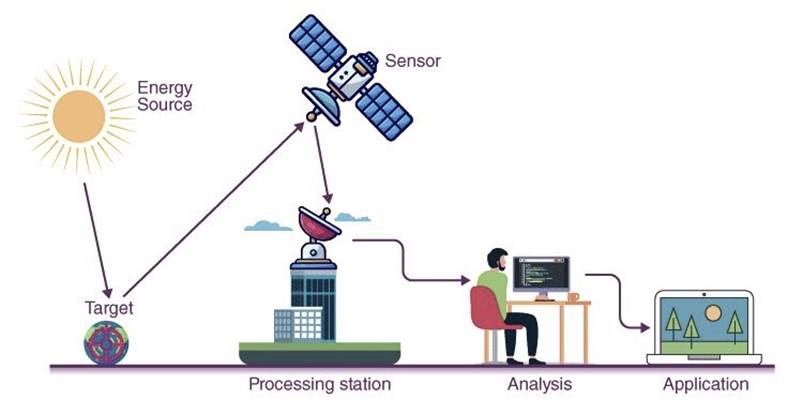
The Basics — What is Remote-Sensing?
- Remote-sensing = observing the Earth without physical contact using:
- satellites
- aircraft / drones
- ground-based sensors
- Works by analysing electromagnetic radiation (EMR) reflected or emitted by Earth-surface features.
Spectral Signatures
- Every object reflects/absorbs EMR differently.
- These reflection patterns = spectral signatures (like fingerprints).
- Sensors interpret signatures to identify:
- healthy crops vs stressed crops
- minerals vs soil
- water vs land
- vegetation types / species
Vegetation Monitoring — NDVI & Biomass
- Healthy plants:
- absorb red light (for photosynthesis)
- reflect near-infrared (NIR) (to avoid heat stress)
Normalised Difference Vegetation Index (NDVI)
- High NDVI → healthy vegetation
- Low NDVI → drought / disease stress
Evidence:
Journal of Plant Ecology (2008) — spectral data enables mapping of plant communities & forest species at landscape scale.
Applications
- crop health monitoring
- drought early warning
- forest biomass & carbon-storage estimation (climate mitigation)
Water Mapping — NDWI & SAR
Optical Water Mapping
- Water reflects visible green
- Strongly absorbs NIR & SWIR
Normalised Difference Water Index (NDWI)
→ High values over water bodies
Modified NDWI (MNDWI)
→ Better in urban areas (distinguishes water vs shadows)
Limitation
- Optical sensors fail during:
- cloud cover
- night
- storms / cyclones
Synthetic Aperture Radar (SAR)
- Active microwave sensor
- Sees through clouds & darkness
- Calm water = smooth mirror → black on radar image
→ Enables flood mapping during cyclones
Key Missions
- NASA–ISRO NISAR
- Sentinel-1 (ESA)
- RISAT series (ISRO)
Subsurface Mapping — Minerals, Oil & Gas
Hyperspectral Sensing
- Splits light into hundreds of narrow bands
- Produces per-pixel spectral fingerprints
Applications
- mineral prospecting (Cu, Au, Li)
- alteration-zone mapping
- soil & rock composition studies
Evidence:
Ore Geology Reviews (2023) — hyperspectral sensors map hydrothermal alteration zones linked to ore deposits.
Oil & Gas Exploration
Micro-seepage detection
- Hydrocarbons leaking through micro-cracks:
- alter soil chemistry
- stress vegetation → yellowing leaves
- Satellites detect these subtle spectral anomalies
Structural Mapping
Anticlines / Dome-fold traps
- Surface folds suggest similar subsurface geometry
Tools
- Landsat, ASTER (NASA) → structural imaging
- Bathymetry via ocean-surface gravity anomalies
- Magnetometry → detects depth of magnetic basement rocks
Satellites don’t say “oil is here”, but “this structure can hold oil”.
Groundwater Mapping — GRACE Mission
- Large aquifers exert stronger gravitational pull
- NASA GRACE (2002–2017) used twin satellites to:
- measure distance variation caused by gravity changes
- infer groundwater volume shifts
Landmark finding (Nature, 2009)
- North India groundwater depletion detected from space
→ linked to irrigation withdrawals
Benefits of Remote-Sensing
- Faster, cheaper, low-impact exploration
- Avoids random drilling / geological disturbance
- Enables:
- precision agriculture
- climate monitoring
- disaster management
- resource conservation
Environmental Value
- helps ensure resources are not over-exploited
- supports sustainable groundwater & forest management
Limitations
- Requires ground-truth validation
- Interpretation depends on:
- atmospheric conditions
- sensor resolution
- calibration accuracy
- Cannot detect resources directly — only indicators
Police in States step up social media monitoring
Why is it in News?
- Over the last five years, States have significantly scaled up social-media monitoring infrastructure within police departments.
- Number of dedicated social-media monitoring cells
- 2020: 262 cells
- 2024: 365 cells (across 28 States + 8 UTs)
- Growth reflects policing priorities around:
- misinformation, hate speech, rumour-control
- cyber-enabled crime & communal mobilisation
- protest surveillance & law-and-order monitoring
Data Source: Data on Police Organisations (DoPO), Bureau of Police Research & Development (BPR&D).
Relevance
GS-2 | Governance, Policing & Rights
- Surveillance, privacy, proportionality doctrine
- Cyber-policing & law-and-order institutional reforms
- Articles 19 & 21 — speech, dignity, due-process concerns
GS-3 | Internal Security & Cybersecurity
- Tech-centric policing, misinformation & hate-speech monitoring
- Cyber-crime ecosystem, digital intelligence, drones & analytics
The Basics — What Are Social-Media Monitoring Cells?
- Specialised police units that:
- track Facebook, X, WhatsApp, Instagram, Telegram, Snapchat etc.
- flag hate speech, fake news, mobilisation calls, financial scams
- identify law-and-order triggers & cyber-crime signals
- Evolved from cyber-crime police stations → now distinct units since 2021 in DoPO reporting.
State-wise Expansion — Key Facts & Numbers
States with highest number of monitoring cells (2024):
- Bihar — 52
- Maharashtra — 50
- Punjab — 48
- West Bengal — 38
- Assam — 37
Significant growth cases
- Manipur: 3 (2020) → 16 (2024)
(growth despite ~140-day Internet suspension during 2023 ethnic violence) - Assam: 1 (2022) → 37 (2024)
- West Bengal: 2 (2022) → 38 (2024)
- Punjab: 24 (2022) → 48 (2024) (doubled)
Parallel Trend — Rise in Cybercrime Policing
- Cyber-crime police stations
- 2020: 376
- 2024: 624
- Indicates shift from traditional policing → techno-forensics & platform-driven crime monitoring.
Related Policing Infrastructure — Data Highlights
- Drones with State/UT police: 1,147 (up from 1,010 in 2023)
- Vacancies:5,92,839 posts vacant
- Against sanctioned strength 27,55,274
- Social composition of actual strength
- SC: 3,30,621
- ST: 2,31,928
- OBC: 6,37,774
Insight: Expansion of digital surveillance capacity is occurring alongside large manpower shortages.
Why Are Police Expanding Social-Media Monitoring?
- Evolving crime trends
- cyber-fraud, extortion, phishing networks
- hate-speech mobilisation & rumour-spread
- radicalisation & organised protest coordination
- Real-time early-warning systems
- riot-prevention
- misinformation control during elections / crises
- Evidence collection
- digital footprints for prosecution
Governance & Civil-Liberty Concerns
- Risk of over-surveillance
- chilling effect on dissent & free speech
- Weak legal oversight
- unclear statutory standards on monitoring protocols
- Privacy risks
- bulk-monitoring vs targeted intelligence
- Capacity vs accountability gap
- rapid expansion without transparency norms
Balancing challenge: Security imperatives ↔ constitutional freedoms (Articles 19 & 21).
Strategic Implications
Positive
- improves situational intelligence
- supports cyber-crime detection
- aids disaster / protest / riot monitoring
Concerns
- potential misuse for political surveillance
- uneven capability across States
- human-resource deficit despite tech growth
Takeaways
- India’s police forces are rapidly institutionalising social-media monitoring, rising from 262→365 cells (2020–2024) alongside cyber-crime station expansion (376→624).
- Trend signals tech-centric policing, but raises issues of privacy, proportionality, and oversight amid large police vacancies.
Mexico’s Popocatépetl volcano — first 3D interior imaging
Why is it in News?
- Scientists in Mexico have produced the first high-resolution 3D interior map of Popocatépetl volcano — one of the most active and dangerous volcanoes in the world.
- The project helps identify where magma accumulates, improving eruption prediction, hazard modelling, and evacuation planning.
- Significance is high because:
- ~25 million people reside within 100 km of the volcano
- Critical infrastructure nearby includes houses, schools, hospitals, and five airports
- Earlier interior images (≈15 years ago) were low-resolution and contradictory.
Relevance
GS-1 | Geography / Geomorphology
- Volcano types, stratovolcano behaviour
- Magma chambers, tectonic-volcanic linkages
GS-3 | Disaster Management
- Hazard mapping, early-warning systems
- Risk-informed evacuation & urban-hazard planning
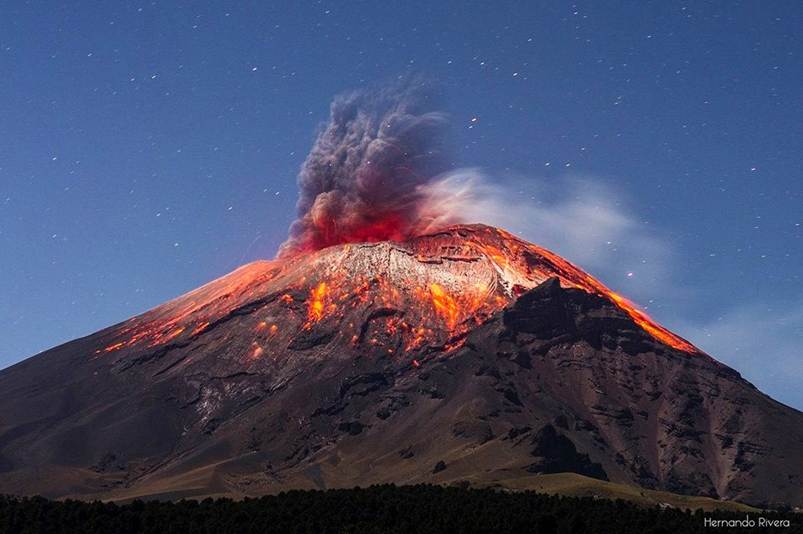
The Basics — Understanding Popocatépetl
- Location: Trans-Mexican Volcanic Belt
- Elevation: 5,452 m
- Age: current structure emerged >20,000 years ago
- Continuous activity since 1994 — ash, gas, smoke emissions almost daily
- Last major dome-collapse eruption: 2023
- Known for:
- frequent ash plumes
- lava domes that build and collapse
- pyroclastic activity risk
Popocatépetl is considered a high-risk stratovolcano due to population exposure + persistent activity.
What Did the Scientists Achieve?
- Created the first 3-dimensional cross-sectional image of the volcano’s interior
- Imaging depth: ≈18 km below the crater
- The model reveals:
- multiple magma pools at different depths
- separated by rock layers / solidified material
- greater concentration towards the southeast of the crater
- Demonstrates that magma storage is not a single chamber
→ instead a complex multi-reservoir system
Implication: Eruptions may not behave uniformly — risk patterns vary spatially.
How Was the 3D Image Created?
Seismic Imaging + AI Processing
- Inside an active volcano, magma, gases, rocks & aquifers move constantly
- Motion generates seismic vibrations
- Researchers installed seismographs that:
- record ground motion ≈100 times per second
- Massive datasets processed using AI-based inference models
- infer material type, temperature, depth, and density contrasts
Field Challenges
- Work carried out on the volcano slopes for 5 years
- Risks included:
- eruptions & explosions
- harsh weather
- damaged instruments (rats, shocks, battery failures)
- Some data sets were lost / corrupted, increasing mission difficulty
Why This Matters — Disaster Risk & Public Safety
- The new model helps:
- identify magma pathways & accumulation zones
- assess likelihood of dome formation / collapse
- improve eruption forecasting windows
- inform evacuation strategy & exclusion-zone planning
- Repeating the study periodically will allow:
- change-detection over time
- tracking magma movement before eruptions
The volcano becomes a “natural laboratory” for predictive volcanology.
Facts & Data — Key Points to Remember
- Elevation: 5,452 m
- 3D imaging depth: 18 km
- Population at risk (within 100 km): ≈ 25 million
- Active since: 1994
- Recent eruption event: 2023
- Hazards: ash plumes, dome collapse, pyroclastic activity
- Purpose of imaging: magma mapping & eruption-risk assessment
Takeaways
- Popocatépetl’s first 3D subsurface map (to 18 km) reveals multiple magma reservoirs, improving eruption prediction & disaster preparedness for ~25 million people living nearby — a major advancement in volcano monitoring using AI-enabled seismic imaging.
Places in News
Relevance
GS-1 | Geography (Location-based)
- Neighbouring countries, coastlines, strategic geography
- Caribbean, North America, Arctic region mapping
GS-2 | International Relations / Global Politics
- U.S.–Latin America relations
- Drugs, migration, security geopolitics
- Arctic competition & strategic resources
🇨🇴 Colombia — Why in News?
Trump threatened action over failure to curb drug trafficking; Colombia remains a major global cocaine producer. Bilateral strain under President Gustavo Petro.
Neighbouring Countries
- Panama (NW)
- Venezuela (E)
- Brazil (SE)
- Peru (S)
- Ecuador (SW)
Geographic Notes
- Lies in North-western South America
- Only South American country with coastlines on both Pacific Ocean & Caribbean Sea
- Andes Mountains run across the country
- Major river basins: Amazon & Orinoco
Data Angle
- Accounts for ~⅔ of global cocaine output
🇲🇽 Mexico — Why in News?
Trump warned of action over fentanyl-trafficking networks impacting the U.S.; debates around
Neighbouring Countries
- United States (N)
- Guatemala (SE)
- Belize (SE)
Geographic Notes
- Located in North America
- Coastlines on Pacific Ocean & Gulf of Mexico / Caribbean Sea
- Dominated by Mexican Plateau, Sierra Madre ranges, and Yucatán Peninsula
- Part of the Ring of Fire → earthquake & volcano-prone
Policy Context
- Fentanyl crisis driving security-centric U.S.–Mexico relations
🇨🇺 Cuba — Why in News?
Accused by Trump of supporting terrorism & drug-trafficking networks; renewed geopolitical friction amid economic crisis & migration flows.
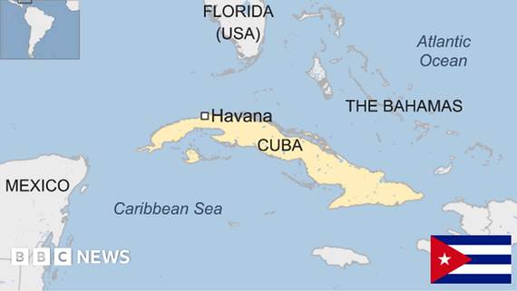
Neighbouring Countries (Maritime Proximity)
- United States (Florida) — North
- Mexico — West
- Bahamas — NE
- Haiti (Hispaniola) — East
- Jamaica — South
Geographic Notes
- Largest island in the Caribbean
- Located between Gulf of Mexico & Atlantic Ocean
- Part of the Greater Antilles archipelago
Strategic Layer
- Symbolically key in U.S. hemispheric policy & Cold War legacy politics
🇬🇱 Greenland (Denmark) — Why in News?
Trump reiterated interest in annexing Greenland, citing strategic defence priorities.
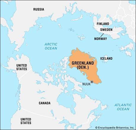
Neighbouring / Nearby Regions
- Canada — West (across Baffin Bay)
- Iceland — SE (across Denmark Strait)
- Arctic Ocean — North
- North Atlantic Ocean — South & East
Geographic Notes
- World’s largest island; autonomous territory under Kingdom of Denmark
- Mostly covered by the Greenland Ice Sheet
- Hosts Pituffik (Thule) Space / Air Base
- Critical to Arctic sea-lanes, missile-defence, and rare-earth resources
Strategic Context
- Rising U.S.–China–Russia competition in the Arctic


