Content
- Places in News: Kharg Island (Iran)
- Atomic clock on NavIC satellite calls time; ISRO’s ‘GPS’ weakens
- Rising Tiger Deaths in Maharashtra: Conservation and Human–Wildlife Conflict
- Earth’s magnetic flips can last 70,000 years, new study finds
- U.S. Section 301 Investigations Against India
- Ice patches on melting glaciers greater threat than thought: ISRO scientists
- V.O. Chidambaranar Port Digital Twin Initiative
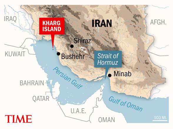
Places in News: Kharg Island (Iran)
Location and Geographic Setting
- Kharg Island is located in the Persian Gulf, about 25 km off the southern coast of Iran in the Bushehr Province.
- The island lies close to major maritime energy routes leading toward the Strait of Hormuz, one of the world’s most critical oil shipping chokepoints.
- Due to its strategic location in the northern Persian Gulf, the island plays a central role in Iran’s oil export infrastructure and maritime logistics network.
Relevance
- Prelims – Geography / IR: Location of Kharg Island in the Persian Gulf near the Strait of Hormuz, a key global oil export terminal of Iran.
- GS II – International Relations: Reflects U.S.–Iran tensions and geopolitical competition in the Persian Gulf affecting regional security.
Practice Question
- “Strategic maritime chokepoints and energy infrastructure in the Persian Gulf play a critical role in global energy security.”Discuss the geopolitical significance of the Persian Gulf region and its implications for India’s energy security.(250 Words)
Why Kharg Island is in the News?
Recent Conflict Developments
- During escalating tensions in West Asia, U.S. forces reportedly carried out strikes on military targets on Kharg Island.
- Iran warned that attacks on its strategic islands would lead to retaliation against U.S.-linked oil, energy and economic facilities in the region.
- The developments form part of the broader U.S.–Iran geopolitical tensions affecting energy infrastructure and maritime security in the Persian Gulf region.
Strategic Importance of Kharg Island
Iran’s Major Oil Export Terminal
- Kharg Island hosts Iran’s primary crude oil export terminal, through which a large proportion of the country’s oil shipments are loaded onto tankers.
- Estimates suggest that a majority of Iran’s crude oil exports pass through facilities located on the island, making it a critical energy hub.
Energy Infrastructure
- The island contains:
- Large oil storage tanks
- Loading terminals for supertankers
- Pipelines connecting mainland oil fields to export facilities.
- Because of this infrastructure, Kharg Island is often considered the heart of Iran’s oil export system.
Military and Strategic Role
- Kharg Island has long been a strategic military asset for Iran, hosting defence installations to protect oil infrastructure and maritime routes.
- During the Iran–Iraq War (1980–1988), the island was frequently targeted in the “Tanker War”, when both sides attacked oil shipping facilities in the Persian Gulf.
- Iran maintains defensive capabilities around the island to protect its energy exports and maritime sovereignty.
Prelims Pointers
- Kharg Island
- Located in the Persian Gulf.
- Off the coast of Bushehr Province, Iran.
- Hosts Iran’s largest oil export terminal.
- Strait of Hormuz
- Strategic maritime chokepoint connecting the Persian Gulf with the Arabian Sea.
- Iran–Iraq War (Tanker War phase)
- Energy infrastructure in the Persian Gulf was frequently targeted.
Other Places in Iran in News
- Tehran – Capital of Iran; major political, military and economic centre.
- Chabahar Port – Located on the Gulf of Oman; strategically important for regional connectivity (including India’s access to Central Asia).
- Isfahan – Major industrial and nuclear research hub in central Iran.
- Bushehr – Coastal province hosting the Bushehr Nuclear Power Plant and offshore oil infrastructure.
- Strait of Hormuz – Global energy chokepoint connecting the Persian Gulf with the Arabian Sea.
Atomic clock on NavIC satellite calls time; ISRO’s ‘GPS’ weakens
Context
- The last operational atomic clock aboard the satellite IRNSS‑1F has failed, according to the Indian Space Research Organisation (ISRO).
- This development weakens India’s regional navigation system NavIC (Navigation with Indian Constellation), which depends on highly precise atomic clocks to deliver navigation and timing services.
- The satellite was launched in March 2016 and completed its design mission life of 10 years recently, though it will continue limited operations such as broadcast messaging services.
Relevance
- GS III – Science & Technology: Highlights the importance of atomic clocks for satellite navigation systems like NavIC and challenges in India’s indigenous space infrastructure.
- GS III – Security / Strategic Technology: Indigenous navigation systems ensure strategic autonomy in defence, aviation and maritime navigation.
Practice Question
- Discuss the strategic and technological significance of India’s NavIC satellite navigation system. What challenges has the system faced in achieving operational reliability?(250 Words)
Static Background: NavIC (Indian Regional Navigation System)
What is NavIC?
- NavIC (Navigation with Indian Constellation) is India’s indigenous satellite navigation system, designed to provide accurate position, navigation and timing services.
- The system was earlier known as the Indian Regional Navigation Satellite System (IRNSS).
- It provides navigation services over India and surrounding regions up to about 1,500 km beyond Indian borders.
Development and Launch Timeline
- The IRNSS constellation satellites were launched between 2013 and 2018.
- In total nine satellites have been launched, of which eight successfully reached their intended orbit.
- The last satellite of the original constellation, IRNSS‑1I, was launched in 2018 as a replacement for a malfunctioning satellite.
Role of Atomic Clocks in Navigation Satellites
Importance of Atomic Clocks
- Atomic clocks are essential components of navigation satellites because precise time measurement enables accurate calculation of position and distance.
- Satellite navigation works by measuring the time taken for signals to travel from satellites to receivers on Earth.
- Even a nanosecond error can cause positioning errors of several metres, making atomic clock precision crucial.
Type of Clocks Used
- The early NavIC satellites used rubidium atomic clocks procured from the Swiss company SpectraTime.
- Failure of these clocks has affected the reliability of several satellites in the constellation.
Replacement Satellites and Upgrades
NVS Series Satellites
- ISRO has begun deploying a next-generation NavIC satellite series called the NVS series to replace ageing satellites.
NVS-01
- The satellite NVS‑01, launched in May 2023, carries an indigenously developed rubidium atomic clock, marking a technological milestone for India.
NVS-02
- The second satellite NVS‑02, launched in January 2025, failed to reach its intended orbit due to launch vehicle anomalies.
Future Launch Plans
- ISRO has announced plans to launch at least three additional satellites by the end of 2026 to strengthen the NavIC constellation.
Comparison with Global Navigation Systems
| Navigation System | Country/Region | Coverage | Approx. Satellites |
| GPS (Global Positioning System) | United States | Global | ~30 |
| GLONASS | Russia | Global | ~24 |
| BeiDou | China | Global | ~35 |
| Galileo | European Union | Global | ~24 |
| NavIC | India | Regional (1,500 km around India) | 7–8 planned |
- Unlike other systems that offer global coverage, NavIC is designed primarily for regional navigation services.
Strategic Importance of NavIC
Technological Sovereignty
- Indigenous navigation capability ensures strategic independence in critical sectors such as defence, aviation and maritime navigation.
- In times of geopolitical conflict, access to foreign navigation systems could potentially be restricted.
Civilian Applications
- NavIC supports applications such as:
- disaster management
- vehicle tracking
- fleet management
- mobile phone navigation
- timing services for telecommunications and financial networks.
Standard Time Reference
- The Government of India has encouraged domestic industries and electronic manufacturers to rely on NavIC signals for determining Indian Standard Time (IST).
Challenges Faced by NavIC
Satellite Ageing
- Several satellites in the original constellation are approaching or exceeding their design life of about 10 years.
Atomic Clock Reliability
- Failures of imported atomic clocks have reduced operational redundancy and reliability of the system.
Limited Coverage
- NavIC currently provides regional rather than global coverage, limiting its adoption for international navigation applications.
Device Compatibility
- Integration of NavIC receivers into smartphones, vehicles and navigation devices remains limited though improving.
Way Forward
Indigenous Atomic Clock Development
- Strengthen domestic capability in high-precision atomic clock technology to reduce dependence on foreign suppliers.
Satellite Constellation Expansion
- Launch replacement satellites and expand the constellation to ensure redundancy and uninterrupted navigation services.
Integration with Consumer Devices
- Encourage integration of NavIC chips into smartphones, automobiles and IoT devices.
International Collaboration
- Explore interoperability with other global navigation systems to enhance accuracy and global usability.
Policy Support
- Continue policy initiatives promoting NavIC adoption across government infrastructure, telecom networks and transportation systems.
Prelims Pointers
- NavIC: India’s regional satellite navigation system.
- Coverage: India and up to 1,500 km beyond its borders.
- IRNSS satellites: Original constellation launched between 2013 and 2018.
- Atomic clocks: Critical for precise timing in navigation satellites.
- NVS-01: First NavIC satellite carrying indigenous rubidium atomic clock.
Rising Tiger Deaths in Maharashtra: Conservation and Human–Wildlife Conflict
Context
- According to data from the National Tiger Conservation Authority (NTCA), 166 tiger deaths were recorded in India in 2025, of which 41 occurred in Maharashtra, the highest among States.
- The information was provided in the Maharashtra Legislative Council by Forest Minister Ganesh Naik during the Budget session while responding to concerns regarding recent tiger deaths in Pench Tiger Reserve.
- The deaths included incidents involving an adult tiger and cubs, raising questions about poaching, habitat degradation and human–wildlife conflict in tiger habitats.
Relevance
- GS III – Environment / Biodiversity: Highlights tiger conservation challenges, habitat fragmentation and human–wildlife conflict in India’s protected areas.
- GS III – Conservation Governance: Examines the effectiveness of Project Tiger, NTCA and wildlife protection laws in managing wildlife populations.
Practice Question
- “Rising tiger populations have paradoxically intensified human–wildlife conflict in India.”
Examine the causes of increasing tiger mortality and suggest measures for balancing conservation with human livelihoods.(250 Words)
Static Background: Tiger Conservation in India
Species Profile
- The Bengal Tiger (Panthera tigris tigris) is India’s national animal and a keystone predator essential for maintaining ecological balance in forest ecosystems.
- Tigers require large contiguous forest habitats, prey availability and minimal human disturbance, making them sensitive indicators of ecosystem health.
Conservation Status
- The species is listed as Endangered on the International Union for Conservation of Nature (IUCN) Red List.
- Tigers are included in Schedule I of the Wildlife (Protection) Act, 1972, providing the highest level of legal protection in India.
India’s Tiger Conservation Framework
Project Tiger
- The flagship conservation programme Project Tiger was launched in 1973 to ensure viable populations of tigers in their natural habitats.
- The programme focuses on habitat protection, anti-poaching measures, scientific monitoring and community participation.
National Tiger Conservation Authority
- The National Tiger Conservation Authority is a statutory body under the Ministry of Environment, Forest and Climate Change responsible for implementing Project Tiger and monitoring tiger populations.
Tiger Reserves
- India currently has over 58 tiger reserves, forming a network of protected areas across the country aimed at conserving tiger habitats.
Maharashtra’s Importance in Tiger Conservation
- Maharashtra hosts several important tiger landscapes, including
- Tadoba–Andhari Tiger Reserve
- Melghat Tiger Reserve
- Pench Tiger Reserve
- Sahyadri Tiger Reserve.
- The State has one of the largest tiger populations in India outside central Indian forests, making conservation efforts in the region particularly significant.
- Rapid infrastructure development and expanding human settlements around forest areas have increased pressure on wildlife habitats.
Causes of Tiger Mortality
Poaching and Wildlife Crime
- Illegal hunting for tiger parts used in traditional medicine and illegal wildlife trade networks continues to pose a threat.
- Forest authorities have deployed specialised anti-poaching units such as the Special Tiger Protection Force to combat wildlife crime.
Habitat Loss and Fragmentation
- Expansion of mining, industrial projects, highways and railways has fragmented forest habitats, restricting tiger movement and dispersal.
- Habitat fragmentation often pushes tigers into human-dominated landscapes, increasing conflict risks.
Human–Wildlife Conflict
- Increasing interactions between humans and wildlife occur when animals enter agricultural lands and villages in search of food or territory.
- Such encounters sometimes lead to retaliatory killings or accidental deaths of animals.
Natural Causes
- Some tiger deaths also result from territorial fights, disease, old age or starvation, particularly when prey availability is limited.
Government Measures to Address Tiger Deaths
Anti-Poaching Surveillance
- Authorities have strengthened anti-poaching patrols using Special Tiger Protection Force personnel, dog squads and wildlife crime monitoring units.
Technological Monitoring
- Digital tools such as the M-STrIPES (Monitoring System for Tigers – Intensive Protection and Ecological Status) are used for real-time tracking of patrol routes and wildlife sightings.
Rescue and Treatment Infrastructure
- The State has established Rapid Rescue Units and Transit Treatment Centres to respond quickly to injured wildlife and emergency situations.
Camera Surveillance
- Camera traps and mobile-enabled tracking systems are used to monitor suspicious movements and wildlife behaviour in protected areas.
Environmental Concerns Raised by Activists
- Environmentalists emphasise that deforestation, mining, industrial expansion and infrastructure development are primary drivers of wildlife displacement.
- Activists have argued that protecting habitats and regulating human intrusion into forests is essential for reducing human–animal conflicts.
- Conservation advocates highlight that India has gained global recognition for initiatives such as Project Tiger and Project Lion, making dilution of wildlife protection laws controversial.
Way Forward
Strengthening Habitat Connectivity
- Protect wildlife corridors linking tiger reserves to enable safe movement of animals and genetic exchange between populations.
Landscape-Level Planning
- Integrate wildlife conservation into infrastructure planning, mining policies and regional development strategies.
Conflict Mitigation
- Promote early-warning systems, compensation schemes and community awareness programmes to reduce retaliatory killings.
Strengthening Anti-Poaching Networks
- Improve intelligence sharing, inter-State coordination and technology-driven monitoring to combat illegal wildlife trade.
Scientific Monitoring
- Expand the use of camera traps, GPS collars and ecological monitoring systems for better understanding of tiger behaviour and population dynamics.
Prelims Pointers
- Project Tiger: Launched in 1973 for tiger conservation.
- National Tiger Conservation Authority: Statutory body overseeing tiger conservation.
- M-STrIPES: Digital monitoring system used for tiger protection and patrol management.
- Schedule I (Wildlife Protection Act, 1972): Highest level of protection for wildlife species.
Top States with Highest Tiger Population (All India Tiger Estimation in 2022)
| Rank | State | Tiger Population (2022) |
| 1 | Madhya Pradesh | 785 |
| 2 | Karnataka | 563 |
| 3 | Uttarakhand | 560 |
| 4 | Maharashtra | 444 |
| 5 | Tamil Nadu | 306 |
Earth’s magnetic flips can last 70,000 years, new study finds
Context
- A recent study published in Communications Earth & Environment analysed deep-sea sediment records to examine the duration of Earth’s magnetic field reversals over geological timescales.
- The research indicates that some magnetic reversals may have lasted far longer than the previously assumed ~10,000 years, challenging long-standing geophysical assumptions about the behaviour of Earth’s magnetic field.
- Evidence from sediments dating back around 40 million years to the Eocene epoch suggests that certain reversals lasted 18,000 years and even up to 70,000 years.
Relevance
- Prelims – Geography / Earth Science: Concepts of geomagnetic reversals, magnetosphere and geodynamo.
- GS I – Physical Geography: Studies of magnetic reversals help understand Earth’s core dynamics and planetary evolution.
Practice Question
- Explain the mechanism behind Earth’s magnetic field and discuss the significance of geomagnetic reversals for understanding planetary processes.(250 Words)
Static Background: Earth’s Magnetic Field
Nature of the Magnetic Field
- Earth possesses a global magnetic field generated by convective motion of molten iron and nickel in the outer core, a process known as the geodynamo.
- This magnetic field forms the magnetosphere, a protective shield that deflects high-energy charged particles from the Sun and cosmic radiation.
- Without this shield, solar wind could gradually strip the atmosphere and expose life to harmful radiation.
Magnetic Pole Reversal
What is a Magnetic Reversal?
- A magnetic reversal occurs when the magnetic north and south poles switch positions, causing the polarity of the Earth’s magnetic field to invert.
- These reversals occur irregularly over geological time and are recorded in rocks, sediments and volcanic deposits.
Frequency
- Geological evidence indicates that hundreds of magnetic reversals have occurred during Earth’s history, though they do not follow a fixed periodic cycle.
- The most recent reversal, known as the Brunhes–Matuyama reversal, occurred approximately 780,000 years ago.
Earlier Scientific Understanding
- For decades, geologists believed that most magnetic reversals occurred over relatively short geological periods of about 10,000 years.
- This estimate was derived mainly from high-resolution geological records covering the last 17 million years, which represent only a small portion of Earth’s 4.5-billion-year history.
- Scientists thought this timescale reflected an inherent property of the geodynamo mechanism in the Earth’s core.
New Research Findings
Geological Data Used
- Researchers analysed deep-sea sediment cores from the North Atlantic Ocean, collected during an international ocean drilling expedition.
- The sediments examined formed around 40 million years ago during the Eocene epoch.
Magnetic Recording Mechanism
- As sediments settled on the ocean floor, tiny magnetic minerals aligned with the Earth’s magnetic field.
- When these sediments were buried, the mineral orientation was preserved, creating a permanent geological record of magnetic field direction and intensity.
Analytical Methods
- Scientists used X-ray scanning and magnetic measurements to reconstruct historical magnetic field behaviour.
- Astronomical tuning techniques, linking sediment layers to Earth’s orbital cycles, helped precisely date the magnetic transitions.
Major Discoveries
- The study identified one magnetic reversal lasting about 18,000 years, significantly longer than the conventional 10,000-year estimate.
- Another reversal lasted approximately 70,000 years, representing an exceptionally prolonged transition.
- The longer reversal showed a complex precursor phase and multiple rebound phases, indicating instability in the magnetic field before stabilising.
Role of the Geodynamo
- The Earth’s magnetic field originates from the geodynamo, produced by turbulent convection of liquid iron in the outer core.
- Numerical simulations conducted by the researchers showed that long-duration reversals are a natural but rare outcome of geodynamo dynamics.
- During reversals, the magnetic field temporarily loses much of its strength before re-establishing polarity.
Environmental Implications
Weakened Magnetic Shield
- During prolonged reversals, the weakened magnetic field allows greater penetration of solar and cosmic radiation into the atmosphere.
- This could potentially affect atmospheric chemistry and increase radiation exposure at Earth’s surface.
Influence on Climate and Life
- Prolonged magnetic instability may have influenced ancient environmental conditions and evolutionary processes, although the exact effects remain uncertain.
- Increased radiation levels could potentially affect mutation rates, biological evolution and atmospheric processes.
Importance of Sedimentary Magnetic Records
- Sedimentary rocks preserve paleomagnetic records, allowing scientists to reconstruct the history of Earth’s magnetic field.
- Ocean-floor sediments provide particularly valuable records because they accumulate continuously over millions of years.
- These records help scientists understand long-term changes in Earth’s internal dynamics and planetary magnetic behaviour.
Scientific Significance
- The findings suggest that magnetic reversals are more complex and variable than previously believed, challenging simplified models of the geodynamo.
- Extending the magnetic record further back in geological time can help refine models of Earth’s core dynamics and planetary magnetic evolution.
- Understanding reversal processes also helps scientists assess potential future changes in the Earth’s magnetic field.
Prelims Pointers
- Geodynamo: Process generating Earth’s magnetic field through convection of liquid iron in the outer core.
- Magnetosphere: Region around Earth dominated by its magnetic field that shields the planet from solar wind.
- Magnetic reversal: Event in which Earth’s magnetic north and south poles switch positions.
- Brunhes–Matuyama reversal: Last major geomagnetic reversal (~780,000 years ago).
- Eocene epoch: Geological epoch spanning roughly 56–34 million years ago.
U.S. Section 301 Investigations Against India
Context
- The Office of the United States Trade Representative (USTR) launched two investigations against India and several other countries under Section 301 of the Trade Act of 1974.
- The probes aim to determine whether certain policies or practices of these countries are unreasonable or discriminatory and restrict U.S. commerce, potentially justifying trade retaliation.
- These investigations follow a 2026 ruling by the Supreme Court of the United States, which limited some tariff actions earlier imposed by Donald Trump, prompting the administration to seek alternative legal mechanisms for tariffs.
Relevance
- GS II – International Relations: Reflects trade tensions and protectionist policies affecting India–U.S. economic relations.
- GS III – Economy / Trade: Section 301 investigations could lead to tariffs affecting key Indian export sectors such as solar modules, steel and textiles.
Practice Question
- “Trade protectionism is reshaping global economic relations.”
Discuss the implications of U.S. Section 301 trade investigations for India’s export sectors and global trade governance.(250 Words)
Current U.S. Tariff Situation
- The U.S. administration had earlier imposed reciprocal tariffs of 10% on imports from several countries including India, starting August 6, 2025, under emergency powers.
- After the Supreme Court ruling questioned the broad use of emergency powers under the International Emergency Economic Powers Act (IEEPA), the administration shifted to alternative provisions of the Trade Act of 1974.
- A temporary 10% tariff under Section 122 of the Trade Act of 1974 was introduced for 150 days, with threats of increasing it to 25% if trade imbalances persisted.
- Section 301 investigations are now viewed as the legal pathway for imposing targeted tariffs on specific products once the temporary tariff window expires.
What is Section 301 of the Trade Act, 1974?
- Section 301 empowers the U.S. government to investigate foreign trade practices that violate trade agreements or unfairly burden U.S. commerce.
- It allows the USTR to impose retaliatory tariffs, trade restrictions or other measures against countries engaging in such practices.
- Section 301 investigations were previously used during the U.S.–China trade conflict beginning in 2018.
First Investigation: Excess Manufacturing Capacity
Allegation
- The U.S. alleges that India and other countries have created excess industrial capacity, enabling large-scale exports to the U.S. that undermine American industries.
Sectors Identified
- Solar photovoltaic modules
- Petrochemicals
- Steel
- Textiles
- Health goods
- Construction materials
- Automotive products
Evidence Cited
- Reports indicate India’s solar module manufacturing capacity is nearly three times its domestic demand, suggesting strong export orientation.
- The U.S. also highlighted India’s significant trade surplus with the United States, estimated at $40–58 billion depending on data sources.
U.S. Concern
- Excess capacity allegedly leads to oversupply in global markets and lower export prices, potentially harming U.S. manufacturers.
Second Investigation: Forced Labour Allegations
Scope of Investigation
- A separate probe under Section 301(b) examines whether countries including India have failed to effectively prevent the use of forced labour in production supply chains.
Key Allegation
- If goods are produced using forced labour, they may gain artificial cost advantages, allowing exporters to sell products more cheaply than competitors.
Coverage
- The investigation reportedly covers around 60 countries, including India.
U.S. Policy Context
- The probe aligns with broader U.S. trade measures aimed at eliminating forced labour in global supply chains.
How These Investigations Link to U.S. Tariff Policy ?
Legal Strategy After Court Ruling
- The Supreme Court decision restricted the administration’s ability to impose broad tariffs under emergency powers.
- Section 301 investigations provide a legally stronger mechanism for targeted tariffs on specific sectors.
Timeline
- Investigations typically involve public comments, hearings and economic assessments, often lasting several months.
- If unfair practices are confirmed, tariffs could be imposed by mid-2026 or later.
Strategic Objective
- These investigations are seen as a means to maintain tariff pressure while complying with domestic legal constraints.
Implications for India
Export Risks
- Key export sectors such as solar equipment, steel, chemicals and textiles may face new tariffs if the investigations conclude negatively.
Impact on Bilateral Trade
- The U.S. is India’s largest export market, making tariff barriers particularly significant for India’s export-driven sectors.
Trade Negotiation Dynamics
- The investigations may influence ongoing India–U.S. trade negotiations, potentially being used as leverage in discussions on market access.
Response from Indian Industry
- Industry representatives have emphasised that the investigations are preliminary and will take time, meaning there is no immediate impact on trade flows.
- Export promotion bodies such as the Engineering Export Promotion Council of India have indicated they will seek clarification from the U.S. government.
- Experts suggest the probes could intersect with broader India–U.S. economic cooperation frameworks and trade discussions.
Economic and Strategic Context
Rising Protectionism
- The investigations reflect a broader trend of economic nationalism and trade protectionism, particularly in strategic sectors such as clean energy and manufacturing.
Global Supply Chain Competition
- The U.S. is attempting to protect domestic manufacturing while reducing reliance on foreign supply chains, especially in strategic industries.
Impact on Global Trade
- Similar investigations against multiple countries suggest the U.S. may pursue sector-specific tariffs globally rather than broad trade restrictions.
Challenges for India
Trade Dependence on the U.S.
- Heavy reliance on the U.S. market increases vulnerability to tariff shocks and trade disputes.
Industrial Policy Scrutiny
- India’s industrial policies promoting domestic manufacturing could face greater international scrutiny under trade rules.
Compliance with Labour Standards
- Strengthening labour monitoring mechanisms will be important to avoid allegations related to forced labour in supply chains.
Way Forward
Trade Diplomacy
- India should engage in bilateral negotiations with the U.S. to clarify concerns regarding industrial capacity and labour standards.
Export Diversification
- Expanding exports to Europe, ASEAN, Africa and Latin America can reduce dependence on a single market.
Strengthening Labour Compliance
- Improving labour inspections, supply chain transparency and worker protections will help address forced labour concerns.
Industrial Competitiveness
- Enhancing productivity, innovation and value addition can help Indian industries remain competitive even in the face of tariff barriers.
Prelims Pointers
- Section 301: U.S. trade law allowing retaliation against unfair foreign trade practices.
- Trade Act of 1974: Key legislation governing U.S. trade remedies.
- Section 122: Allows temporary tariffs during balance-of-payments issues.
- IEEPA: International Emergency Economic Powers Act used for economic sanctions.
Ice patches on melting glaciers greater threat than thought: ISRO scientists
Context
- A study by scientists from the Indian Space Research Organisation, published in the journal NPJ Natural Hazards, analysed the 5 August 2025 flash flood in Dharali village, Uttarakhand that destroyed settlements and caused casualties.
- The research concluded that the disaster was triggered by the collapse of an exposed ice patch on the Srikanta Glacier, highlighting new forms of climate-induced cryospheric hazards emerging in the Himalaya.
- The findings emphasise the importance of satellite monitoring and early-warning systems to detect glacier instability and prevent disasters in high-altitude regions.
Relevance
- GS III – Environment / Climate Change: Demonstrates climate-induced cryospheric hazards in the Himalaya, including glacier instability and flash floods.
- GS III – Disaster Management: Highlights the role of satellite monitoring and early warning systems in managing glacier-related disasters.
Practice Question
- “Climate change is increasing the frequency and diversity of cryospheric hazards in the Himalayan region.”Discuss the emerging glacier-related risks in the Himalaya and the role of technology in disaster preparedness.(250 Words)
Static Background: Himalayan Cryosphere
What is the Cryosphere?
- The cryosphere refers to the frozen components of the Earth system, including glaciers, snow cover, ice caps, sea ice, permafrost and frozen ground.
- The Himalayan cryosphere, often called the “Third Pole”, stores the largest volume of ice outside the polar regions and feeds major Asian river systems.
Importance for India
- Himalayan glaciers sustain the headwaters of rivers such as the Ganga River, Brahmaputra River and Indus River, supporting water security for millions of people.
- Rapid glacier retreat due to climate change increases the frequency of cryospheric hazards, including glacial lake outburst floods (GLOFs), ice avalanches and flash floods.
Location of the Dharali Flash Flood Event
- Dharali is located in Uttarkashi District, Uttarakhand, along the upper basin of the Bhagirathi River, a major headstream of the Ganga.
- The village lies at an altitude of approximately 2,650–2,700 metres, downstream of the Khir Gad stream, which originates from the Srikanta Glacier.
- The Khir Gad stream divides the settlement into left-bank and right-bank clusters, increasing vulnerability to flash floods triggered upstream in the glacier-fed basin.
Key Scientific Findings of the Study
Trigger Mechanism of the Flood
- The flash flood was caused by the collapse of an exposed ice patch in the nivation zone of the Srikanta Glacier, which released ice, meltwater and debris downslope.
- The sudden release of this material generated a rapid cryo-hydrological event, producing a flash flood that travelled downstream through the Khir Gad stream into Dharali village.
Evidence from Satellite Observations
- Pre-event satellite imagery revealed persistent exposed ice patches during the ablation season, indicating thinning seasonal snow and firn layers due to ongoing glacier retreat.
- These exposed patches acted as structural weak points, making them more vulnerable to collapse during periods of warming temperatures or heavy rainfall.
Deglaciation Signal
- The study identified the exposure of ice patches as a landscape indicator of deglaciation, reflecting the weakening of protective snow and firn layers on the glacier surface.
Key Cryospheric Concepts
Nivation
- Nivation refers to the erosion of the ground beneath or around a snow patch caused by repeated cycles of freezing and thawing, along with meltwater action.
- Over time, this process creates a nivation hollow, a depression where snow accumulates repeatedly and gradually deepens due to erosion and weathering.
Firn
- Firn is partially compacted snow that has survived at least one melt season and represents an intermediate stage between fresh snow and glacial ice.
- Firn acts as an insulating layer, protecting underlying glacier ice from rapid temperature fluctuations and structural instability.
Ablation Zone
- The ablation zone of a glacier is the region where melting, sublimation and ice loss exceed snow accumulation, leading to net mass loss of the glacier.
Mechanism of Ice Patch Collapse
- Normally, seasonal snow and firn layers stabilise glacier surfaces by insulating underlying ice and reducing temperature fluctuations.
- With climate warming, thinning snow cover exposes glacier ice directly to atmospheric conditions, making it more susceptible to melting, fragmentation and collapse.
- Exposed ice patches respond quickly to temperature changes, rainfall and gravitational instability, potentially triggering sudden mass movements of ice, water and debris.
Cryo-Hydrological Hazards in the Himalaya
Expanding Hazard Spectrum
- Traditionally, glacier hazards in the Himalaya were associated mainly with Glacial Lake Outburst Floods (GLOFs).
- The Dharali event demonstrates that smaller cryospheric instabilities such as ice-patch collapse, rock-ice avalanches and debris flows can also trigger destructive floods.
Historical Example
- The 2021 Chamoli Disaster involved a massive rock-ice avalanche in Uttarakhand that caused flash floods in the Rishi Ganga and Alaknanda river systems.
- Such events highlight increasing instability in Himalayan glacier environments under conditions of rapid warming and glacier retreat.
Role of Satellite Monitoring
Earth Observation Technologies
- Satellite imagery, high-resolution topographic mapping and remote sensing data allow scientists to identify glacier instability, exposed ice patches and changes in snow cover.
- Continuous monitoring of glaciers using satellite-based earth observation systems can detect early warning signs of potential cryospheric hazards.
Early Warning Potential
- Pre-event satellite observations in the Dharali case revealed persistent exposed ice patches before the flood, demonstrating their potential as indicators for disaster preparedness.
- Integrating satellite monitoring with ground-based sensors and hydrological models can improve early-warning systems for mountain communities.
Environmental and Climate Dimension
- Rising temperatures in the Himalaya are causing accelerated glacier retreat and thinning of seasonal snow cover, altering the stability of mountain cryospheric systems.
- Climate-driven deglaciation is increasing the frequency of flash floods, landslides and glacial hazards in fragile mountain ecosystems.
- The Himalayan region is warming faster than the global average, intensifying the risk of downstream disasters in glacier-fed river basins.
Disaster Risk and Governance Challenges
Limited Monitoring Coverage
- Many Himalayan glaciers remain poorly monitored due to difficult terrain, remoteness and limited ground-based instrumentation.
Early Warning Gaps
- Existing early-warning systems focus primarily on GLOFs, while smaller cryospheric instabilities such as ice patch collapse often remain undetected.
Settlement Vulnerability
- High-altitude villages located along glacier-fed streams face high exposure to flash floods, debris flows and landslides, requiring stronger disaster preparedness.
Way Forward
Systematic Glacier Monitoring
- Expand satellite-based glacier monitoring programmes led by ISRO and national research institutions to identify vulnerable glacier zones across the Himalaya.
Hazard Mapping
- Conduct geomorphological mapping of nivation hollows, exposed ice patches and unstable glacier slopes to identify potential flash flood sources.
Integrated Early Warning Systems
- Combine remote sensing data, hydrological models and local monitoring networks to establish real-time early-warning systems for mountain communities.
Climate Adaptation Planning
- Strengthen climate-resilient infrastructure and disaster preparedness strategies in Himalayan regions vulnerable to glacier-related hazards.
Research Collaboration
- Encourage collaboration between ISRO, glaciology institutes and international climate research programmes to improve understanding of cryosphere dynamics.
Prelims Pointers
- Cryosphere: Frozen part of Earth including glaciers, ice sheets, snow cover and permafrost.
- Nivation: Erosion beneath a snow patch due to freeze–thaw cycles.
- Firn: Intermediate stage between snow and glacial ice.
- Ablation zone: Area of glacier where melting exceeds accumulation.
- Third Pole: Himalayan–Tibetan region containing the largest ice reserves outside polar regions.
V.O. Chidambaranar Port Digital Twin Initiative
Context
- V.O. Chidambaranar Port Authority (Tamil Nadu) became the first Indian major port to implement a Digital Twin platform for port management, inaugurated on 23 February 2026 by Union Minister Sarbananda Sonowal.
- The platform creates a real-time digital replica of port infrastructure, assets and maritime operations, enabling advanced monitoring, predictive analytics and data-driven decision-making for efficient and technology-driven maritime logistics.
- The initiative aligns with Maritime India Vision 2030 and Amrit Kaal Vision 2047, which emphasise digitalisation, smart port ecosystems and enhanced operational efficiency to strengthen India’s global maritime competitiveness.
Relevance
- GS III – Infrastructure / Logistics: Demonstrates digital transformation of port infrastructure to improve efficiency and reduce logistics costs.
- GS III – Science & Technology: Application of AI, IoT and Digital Twin technology in maritime logistics and smart infrastructure management.
Practice Question
- “Digital technologies are transforming port management and maritime logistics.”Discuss the significance of digital twin technology in modernising India’s port infrastructure and improving trade efficiency.(250 Words)
Static Background: V.O. Chidambaranar Port
Location and Strategic Significance
- V.O. Chidambaranar Port is located at Thoothukudi (Tuticorin) in Tamil Nadu along the Gulf of Mannar, close to the East–West international shipping route connecting Europe, Asia and the Middle East.
- It was declared a major port in 1974 and renamed after freedom fighter V.O. Chidambaram Pillai, a pioneer of the Swadeshi shipping movement against colonial maritime dominance.
- The port serves the industrial hinterland of southern Tamil Nadu, Kerala and Karnataka, facilitating exports of minerals, fertilisers, petroleum products, containers, coal and general cargo.
Port Characteristics
- It is an artificial deep-sea harbour protected by breakwaters, enabling safe navigation and handling of large cargo vessels and container ships in the southern Indian maritime region.
- The port handles over 30 million tonnes of cargo annually, making it one of the important cargo handling ports on India’s southeastern coast.
Concept of Digital Twin Technology
- A Digital Twin refers to a dynamic virtual replica of physical infrastructure, continuously updated through real-time operational data collected from sensors, enabling monitoring, simulation and optimisation of complex systems.
- The technology integrates Internet of Things (IoT), artificial intelligence, LiDAR mapping, satellite positioning systems and advanced analytics, allowing operators to visualise operations and simulate real-world conditions digitally.
- Digital twins enable predictive maintenance, operational forecasting and risk simulation, improving efficiency, safety and sustainability in complex infrastructure sectors such as ports, airports, urban infrastructure and manufacturing systems.
Key Features of the Digital Twin Platform at VOC Port
Real-Time Operational Monitoring
- The platform provides live visualisation of berth occupancy, vessel movements, crane operations and yard capacity, allowing port authorities to monitor cargo handling operations and maritime traffic dynamically.
Predictive Maintenance
- AI-enabled asset monitoring enables predictive maintenance of cargo-handling equipment such as cranes and conveyors, reducing equipment failures, minimising operational downtime and improving reliability of port logistics infrastructure.
Berth and Traffic Optimisation
- Intelligent scheduling algorithms support efficient vessel berth allocation and cargo operation planning, reducing vessel waiting time, improving berth utilisation and easing maritime traffic congestion within the port ecosystem.
Scenario Simulation
- The digital twin enables “what-if” simulation modelling for peak cargo demand, operational disruptions and extreme weather conditions, helping authorities prepare contingency strategies and improve resilience of port operations.
Sustainability Monitoring
- The system enables tracking of energy consumption and emissions across port infrastructure, supporting environmental monitoring and helping align port operations with sustainability and decarbonisation goals.
Expected Operational Benefits
- The digital twin system is expected to reduce vessel turnaround time by nearly 25%, improving operational efficiency and allowing faster movement of cargo ships within the port ecosystem.
- Predictive analytics improves equipment availability, safety monitoring and cargo-handling productivity, strengthening operational reliability and reducing disruptions in maritime logistics chains.
- Real-time operational intelligence improves decision-making by port authorities, enhancing coordination between logistics operators, shipping companies, terminal operators and port management agencies.
- Energy optimisation and emission monitoring contribute to greener port operations, supporting India’s commitments to sustainable maritime infrastructure and climate-resilient port management.
Governance and Policy Context
Maritime India Vision 2030
- Maritime India Vision 2030 is the flagship roadmap for transforming India into a leading maritime nation, focusing on port modernisation, infrastructure development, digitalisation and enhanced operational efficiency.
- The vision targets global benchmarking of Indian ports, reduction in vessel turnaround time, improved ease of doing business and adoption of advanced technologies such as smart port platforms and digital twins.
Amrit Kaal Vision 2047
- The long-term maritime strategy under Amrit Kaal Vision 2047 aims to develop world-class port infrastructure, green shipping corridors and advanced digital logistics systems to strengthen India’s maritime economy.
Economic Significance
- Ports handle around 95% of India’s trade by volume and nearly 70% by value, making efficient maritime infrastructure critical for economic growth and international trade competitiveness.
- Digital twin technology improves cargo flow management, logistics planning and supply-chain coordination, reducing port congestion and lowering logistics costs for exporters and importers.
- Smart port technologies strengthen India’s position in global maritime logistics networks, helping attract international shipping lines and boosting port-led industrial development under the Sagarmala programme.
Technological Dimension
- The Digital Twin platform integrates IoT sensors, GPS tracking systems, LiDAR mapping, drone surveillance and CCTV networks, enabling real-time data collection from multiple port infrastructure components.
- Artificial intelligence and data analytics process this data to generate predictive insights for maintenance, logistics optimisation and operational planning, improving efficiency and safety in port management.
- Such smart technologies are part of the emerging “Port 4.0” model, which applies Industry 4.0 technologies to maritime infrastructure and global logistics ecosystems.
Environmental Dimension
- Digital monitoring enables ports to track energy consumption, fuel usage and carbon emissions, facilitating adoption of environmentally sustainable port operations.
- Scenario simulation helps ports prepare for climate risks such as cyclones, storm surges and operational disruptions, improving resilience of coastal infrastructure.
- Smart energy management reduces unnecessary power consumption of cranes, vehicles and cargo equipment, supporting green port initiatives and sustainable maritime transport systems.
Strategic and Security Dimension
- Real-time monitoring of vessel movements and port infrastructure improves maritime situational awareness and port security management, reducing risks of accidents or operational disruptions.
- Integration with surveillance technologies such as drones and CCTV strengthens coastal security coordination with agencies like the Indian Coast Guard and port security forces.
- Smart port technologies improve supply chain resilience, which is crucial during geopolitical disruptions, trade shocks or maritime crises affecting international shipping routes.
Challenges
- Implementation of digital twin infrastructure involves high capital investment and technological integration challenges, particularly in ports with legacy systems and outdated operational infrastructure.
- Ports must address cybersecurity risks, as increased digitalisation makes maritime infrastructure vulnerable to cyber attacks targeting logistics networks and critical infrastructure systems.
- Skilled workforce shortages in AI, data analytics and maritime information technology could limit the effective adoption and scaling of smart port technologies across Indian ports.
Way Forward
- The government should gradually expand digital twin systems to all major ports under the Sagarmala programme, creating a nationwide smart maritime logistics network.
- Development of a national maritime cybersecurity framework is essential to protect digitally connected port infrastructure from cyber threats and data breaches.
- Integration of digital twin platforms with the Port Community System (PCS 1x) can enhance coordination among customs authorities, shipping lines, logistics operators and port authorities.
- Adoption of renewable energy, electrified cargo handling systems and carbon monitoring tools can help transform Indian ports into green and sustainable maritime infrastructure hubs.
Major Ports in India
India currently has 13 major ports administered by the central government under the Major Port Authorities Act, 2021.
- Deendayal Port (Kandla) – Gujarat
- Mumbai Port – Maharashtra
- Jawaharlal Nehru Port (Nhava Sheva) – Maharashtra
- Mormugao Port – Goa
- New Mangalore Port – Karnataka
- Cochin Port – Kerala
- V.O. Chidambaranar Port (Tuticorin) – Tamil Nadu
- Chennai Port – Tamil Nadu
- Kamarajar Port (Ennore) – Tamil Nadu
- Visakhapatnam Port – Andhra Pradesh
- Paradip Port – Odisha
- Kolkata Port (Syama Prasad Mookerjee Port) – West Bengal
- Port Blair Port – Andaman and Nicobar Islands
Prelims Pointers
- Digital Twin: Virtual replica of physical infrastructure used for monitoring, simulation and predictive analysis.
- First Indian port with Digital Twin: V.O. Chidambaranar Port (2026).
- Major Port Authorities Act 2021: Replaced Major Port Trusts Act 1963; grants greater autonomy to port authorities.
- Sagarmala Programme: Government initiative for port-led development and maritime infrastructure modernisation.


