Content
- Trump’s 25% Tariff, ‘Penalty’ to Hit India from Tomorrow
- India Launches NISAR Satellite
- Boost the Capacity of Legal Aid Systems
- Restoring Mangroves Can Turn the Tide on India’s Coastal Security
- Kamchatka Peninsula Earthquake
Trump’s 25% tariff, ‘penalty’ to hit India from tomorrow
Announcement by U.S. President Trump (Wednesday):
- 25% tariff on all Indian imports starting August 1.
- Includes an additional penalty (not yet specified).
Relevance : GS 2(International Relations)
Reasons Cited by Trump:
- India’s high tariffs and non-monetary trade barriers.
- India’s continued purchase of military equipment and energy from Russia.
- Criticism of India’s role as a major buyer from Russia during the Ukraine war.
India’s Response (Ministry of Commerce):
- “Studying implications” of U.S. announcement.
- Will take all necessary steps to protect national interest.
Trade Negotiations Status:
- India–U.S. Bilateral Trade Agreement expected by Fall 2025 (still under negotiation).
- A smaller “mini-deal” to reduce retaliatory tariffs has likely failed.
Past Context:
- Trump had earlier threatened 26% tariffs on India.
- Current move slightly lower at 25%, but penalty adds uncertainty.
U.S. Position (as per Trump on Truth Social):
- India is a “friend,” but trade has been low due to high Indian tariffs.
- Accused India of having the “most strenuous and obnoxious” trade barriers.
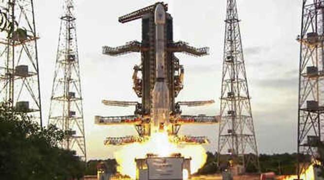
India launches NISAR satellite
Key Points
- Launched on: July 30, 2025
- Launch site: Satish Dhawan Space Centre, Sriharikota, Andhra Pradesh
- Rocket used: GSLV-F16 (Geosynchronous Satellite Launch Vehicle)
Relevance : GS 3(Space , Science and Technology)
What is NISAR?
- Full Form: NASA-ISRO Synthetic Aperture Radar
- Type: Earth Observation Satellite
- Weight: 2,392 kg
- Orbit: Sun-synchronous orbit
- Mission Life: 5 years
- Launch Milestone: First time GSLV launched a satellite into a sun-synchronous orbit
Joint Venture
- Agencies Involved:
- NASA (USA): Built L-band SAR, radar boom, reflector, and payload
- ISRO (India): Developed S-band SAR, satellite bus (I3K), solar panels, and launched the mission
Technical Highlights
- Radar Type: Dual-frequency Synthetic Aperture Radar (SAR)
- NASA’s L-band + ISRO’s S-band
- Unique Feature:
- Uses NASA’s 12-metre unfurlable mesh reflector antenna
- Scans Earth every 12 days, in all weather and day-night conditions
- Swath: 242 km, with high spatial resolution
- Tech: SweepSAR, detects tiny surface changes
Applications
- Monitoring ground deformation, ice movement, vegetation dynamics
- Mapping soil moisture, surface water, farmlands
- Assisting disaster response (earthquakes, floods, landslides)
- Tracking sea ice, ships, shorelines, storms
Mission Phases
- Launch Phase – Completed by GSLV-F16
- Deployment Phase – Begins Day 10 post-launch; 12-metre antenna to unfold
- Commissioning Phase – Tests and calibrations
- Science Phase – Full operation begins
Boost the capacity of legal aid systems
Context
Legal Services Institutions, under the Legal Services Authorities Act, 1987, aim to provide free legal aid to ~80% of India’s population, but reach remains modest — only 15.5 lakh people benefited between April 2023 and March 2024 (a 28% increase from the previous year).
Relevance : GS 2(Judiciary – Reforms)
Infrastructure
- Front offices attached to courts, prisons, and juvenile justice boards provide legal help via empanelled lawyers.
- Legal aid clinics operate in rural areas — 1 clinic for every 163 villages (India Justice Report 2025).
Funding Constraints
- Legal aid budget is <1% of the total justice budget (includes police, prisons, judiciary).
- Total allocation (2017-18 to 2022-23):
- States’ share rose from ₹394 cr to ₹866 cr
- NALSA’s share fell from ₹207 cr to ₹169 cr
- Utilisation of NALSA funds dropped from 75% to 59%
- NALSA guidelines (2023) restricted fund usage without prior approval — e.g., staff hiring, victim compensation, equipment.
Per Capita Legal Aid Spending (2022–23)
- India average: ₹6
- Highest: Haryana ₹16
- Lowest: WB ₹2, Bihar ₹3, UP ₹4
Shrinking Frontline Workforce
- Para-legal volunteers (PLVs):
- Create awareness and resolve disputes.
- Drop by 38% (2019–2024) – now only 3.1 PLVs/lakh (WB & UP: 1 PLV/lakh).
- Poor honorariums: Kerala highest (₹750/day), most States pay ₹500 or less.
Legal Aid Defence Counsel Scheme (LADC)
- Started in 2022 — dedicated legal aid to accused persons only, modeled on the public defender system.
- Operational in 610 of 670 districts.
- ₹200 cr allocation in 2023–24 (fully used), but dropped to ₹147.9 cr in 2024–25.
- Early potential noted, but too soon to assess long-term success.
Key Challenges
- Underfunding, underutilization, and manpower shortage.
- Low trust, inconsistent service quality, and lack of accountability persist.
- Without resource investment, legal aid falls short of the constitutional promise of justice for all.
Restoring mangroves can turn the tide on India’s coastal security
Background: What Are Mangroves?
- Definition: Mangroves are salt-tolerant, forested wetlands found in tropical and subtropical coastal zones.
- Unique Feature: Survive in saline, intertidal zones with low oxygen levels through specialized roots (e.g., pneumatophores).
- Global Context: Mangroves are part of “blue carbon ecosystems” — sequester CO₂ in soil, roots, and biomass.
Relevance : GS 3(Environment and Ecology)
Ecological & Social Significance of Mangroves in India
- Disaster Risk Reduction:
- Act as natural shields during cyclones, storm surges, and tsunamis.
- Example: 2004 Tsunami — areas with mangrove cover had reduced damage and mortality.
- Biodiversity Hotspots:
- Habitat for fish, crustaceans, molluscs, insects, and migratory birds.
- Support local food chains and aquatic biodiversity.
- Carbon Sequestration:
- Store blue carbon—far more per unit area than terrestrial forests.
- Key tool in India’s climate mitigation efforts under the Paris Agreement.
- Livelihoods & Culture:
- Source of livelihoods for coastal communities — e.g., honey gathering (Sundarbans), fishing, and eco-tourism.
- Integral to indigenous knowledge and traditional resource use.
Key Threats to Mangroves
- Urban Expansion: Coastal infrastructure, ports, and real estate projects (e.g., Mumbai, Chennai).
- Aquaculture: Shrimp farming and commercial fisheries degrade soil, alter salinity.
- Pollution: Plastic, sewage, and industrial effluents reduce regeneration capacity.
- Climate Change:
- Rising sea levels → prolonged submergence.
- Changing rainfall and salinity disrupt growth cycles.
- IUCN Warning: Over 50% of global mangroves may collapse by 2050 without urgent action.
India’s Mangrove Landscape
- Total Area: ~4,900 sq. km (India State of Forest Report 2021).
- Major States: West Bengal (Sundarbans), Gujarat, Andhra Pradesh, Odisha, Tamil Nadu, Maharashtra.
- Highest Coverage: Gujarat (23.6% of India’s mangrove area).
State-Level Success Stories
Tamil Nadu
- Problem: Degradation due to shrimp farming, pollution, disrupted hydrology.
- Progress:
- Mangrove cover doubled from 4,500 to 9,000 hectares (2021–2024).
- Green Tamil Nadu Mission: Focused restoration in Thanjavur, Tiruvarur, and Cuddalore.
- Notable Projects:
- Muthupettai Estuary (2017): 115 ha restored by MSSRF + local committees.
- 19 canals dug, 4.3 lakh Avicennia seeds, 6,000 Rhizophora propagules planted.
- Chennai (Kazhipattur, 2024):
- 12,500 seedlings from 5 species planted.
- Invasive Prosopis juliflora removed to restore native vegetation.
- Muthupettai Estuary (2017): 115 ha restored by MSSRF + local committees.
Maharashtra (Mumbai)
- Project: 2025 Amazon–BMC–Hasten Regeneration collaboration on Thane Creek.
- Funding: $1.2 million (₹10.3 crore).
- Features:
- 3.75 lakh mangroves planted, targeting flamingo habitat.
- Plastic cleanup: Trash booms to intercept 150 tonnes of waste.
- Livelihood Support: Women employed in plantation and maintenance.
Gujarat
- Programme: Central government’s MISHTI (Mangrove Initiative for Shoreline Habitats & Tangible Incomes).
- Achievements:
- 19,000+ hectares planted (2023–2025).
- Exceeded 5-year national target early.
- Focus Areas: Coastal Kutch and Saurashtra.
- Goals: Enhance climate resilience, ecotourism, and blue carbon goals.
Policy and Institutional Support
- Green Tamil Nadu Mission: State-led restoration with scientific collaboration.
- MISHTI (2023):
- Central initiative for large-scale mangrove plantation.
- Emphasis on livelihood-linked restoration.
- Corporate Partnerships:
- Example: Amazon’s “Right Now Climate Fund” supports climate-smart restoration with social co-benefits.
- Role of Research Institutions:
- M.S. Swaminathan Foundation, ATREE, and other NGOs play a vital role in site assessment, community engagement, and ecological planning.
Key Takeaways for Policy
- Mangroves = Natural Infrastructure:
- Should be prioritized in National Adaptation Plans and State Action Plans on Climate Change (SAPCCs).
- Community-led Conservation:
- Success hinges on involving local communities, Panchayats, and women’s groups.
- Nature-Based Solutions (NbS):
- Restoration with co-benefits for biodiversity, carbon, and livelihoods is emerging as a key approach.
- India’s Global Role:
- As a megadiverse nation, India’s success in mangrove conservation enhances its voice in UNFCCC, CBD, and blue economy platforms.
Kamchatka Peninsula Earthquake
Core Event Overview
- A massive 8.8 magnitude earthquake struck the Kamchatka Peninsula in Russia’s far-east on July 30, 2025.
- Epicenter: Approximately 500 km east of Moscow, affecting northern Pacific Ocean regions.
- It triggered a tsunami alert across several countries, including those on both sides of the Pacific Ocean.
- Tsunami waves were recorded (up to 3 meters) in some places such as:
- Alaska Peninsula
- Petropavlovsk-Kamchatsky in Russia
- Hokkaido in Japan
- Minor flooding was reported but no significant damage or loss of life was initially confirmed.
Relevance : GS 1(Geography)
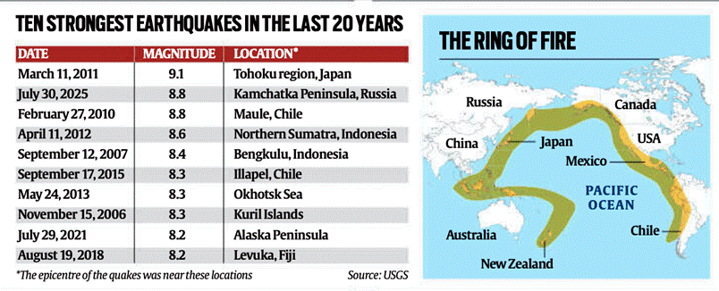
Seismic Context: Ring of Fire
- The epicenter lies on the Circum-Pacific Seismic Belt, famously known as the “Ring of Fire”:
- A horseshoe-shaped seismic belt encircling the Pacific Ocean.
- Accounts for ~80% of the world’s strongest earthquakes.
- This region experiences frequent and violent tectonic activity due to:
- Presence of multiple subduction zones.
- Convergent plate boundaries where oceanic plates sink beneath continental or other oceanic plates.
Global Comparison: Top Earthquakes (Past 20 Years)
- The Kamchatka quake ties for 2nd place (8.8 magnitude) among the top 10 earthquakes since 2005:
- Strongest: Tohoku, Japan (2011) – 9.1
- Other notable 8.8 quakes: Chile (2010), Sumatra (2005), Kamchatka (2025)
- Pattern: Most quakes in the top 10 have occurred within the Ring of Fire.
Why So Active: Tectonic Process in Kamchatka
- Kamchatka Peninsula is one of the most active geological zones due to:
- Subduction of the Pacific Plate beneath the Okhotsk Plate.
- This tectonic movement causes:
- Build-up of seismic stress
- Sudden release of energy as earthquakes
- This region has recorded over 130 significant quakes of >7.5 magnitude since 1900.
- Notable event: 1952 earthquake of magnitude 9.0 in the same region.
Mechanism of Subduction Quakes
- Process:
- Two plates collide, and one subducts under the other.
- This builds up immense stress until sudden rupture and energy release occurs.
- Subduction-zone quakes are:
- Longer in duration
- Often followed by tsunamis
- Deep-focus in nature, affecting a wider area
Scientific and Risk Implications
- Earthquake in Kamchatka serves as a case study for:
- Seismic hazard preparedness.
- Plate tectonics and deep-focus earthquakes.
- Scientists warn of ripple effects across other Ring of Fire zones.
- Particularly vulnerable zones: Japan, Alaska, Indonesia, Chile
- Modern data collection helps predict aftershocks and assess tsunami risks.
Human & Policy Implications
- Kamchatka is sparsely populated: ~362,000 residents, mostly in Petropavlovsk.
- Hence, damage and casualties were relatively low despite the quake’s strength.
- Had a similar magnitude quake occurred in a densely populated area (e.g., Nepal 2015), the human toll could be much higher.
- Underscores the need for:
- Seismic early warning systems
- Disaster readiness even in less populated but seismically active areas
Geopolitical and Global Preparedness Lessons
- Events like this:
- Highlight the interconnected nature of seismic risks in the Pacific.
- Stress the importance of transnational cooperation on early warnings and mitigation.
- India, although not in the Ring of Fire, can learn from:
- Japan’s model of community drills, building codes, and real-time alerts.
Conclusion: Key Takeaways
- The Kamchatka quake is among the top three strongest quakes of the century so far.
- It reaffirms that seismic unpredictability remains high in the Ring of Fire.
- Preparedness, awareness, and advances in tectonic science are critical to minimizing human impact.
- Russia’s quake is a warning signal for all nations vulnerable to tectonic movements—especially those along subduction zones.


