Context
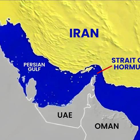
- The Strait of Hormuz crisis, triggered by Iran blocking a ~20 nautical miles wide chokepoint, has disrupted global oil and gas supplies, highlighting the enduring relevance of geography in geopolitics.
- The episode reinforces the concept of “revenge of geography”, where physical features continue to constrain human and technological advancements despite globalisation and modern capabilities.
Relevance
- GS Paper I: Geography (physical features, human–environment interaction)
- GS Paper II: International Relations (West Asia, maritime geopolitics)
Practice Questions
Q.“The Strait of Hormuz crisis highlights the enduring relevance of geography in geopolitics.” Discuss in the light of the concept of ‘revenge of geography’. (250 words)
Core Concept: Revenge of Geography
- The idea implies that geographical features such as straits, mountains, and rivers continue to shape politics, economy, and security, limiting human ability to completely overcome natural constraints.
- Despite technological progress, strategic chokepoints and terrain still determine trade routes, conflict outcomes, and power projection, reaffirming geography’s enduring influence.
About Strait of Hormuz
- The Strait of Hormuz is a narrow maritime passage (~20 nautical miles wide) connecting the Persian Gulf to the Gulf of Oman, serving as a critical global energy chokepoint.
- A significant share of global oil and gas trade passes through it, making disruptions highly consequential for energy security, global markets, and geopolitical stability.
Maritime Chokepoints & Global Examples
- Strategic straits like Malacca, Bab-el-Mandeb, Gibraltar, Bosporus, and Bering Strait function as critical nodes of global trade and military movement, often becoming sites of geopolitical contestation.
- For instance, Malacca Strait (~82,000 vessels annually) and Bab-el-Mandeb demonstrate how narrow waterways can influence global supply chains and conflict dynamics.
Geography–History Linkages
- Historical events such as the Battle of Tsushima (1905), Umayyad conquest via Gibraltar (711 CE), and control of Bosporus during Ukraine conflict show geography shaping military and political outcomes.
- Maritime features have historically determined trade dominance, colonial expansion, and strategic advantage, reinforcing geography’s role in shaping civilisation trajectories.
Multi-Dimensional Analysis
Environmental / Geographical Dimension
- Physical features like straits, isthmuses, peninsulas, rivers, and plains define resource distribution, connectivity, and ecological systems, shaping human settlement and economic activity patterns.
Economic Dimension
- Global trade remains heavily dependent on maritime chokepoints, with disruptions causing energy crises, inflation, and supply chain shocks, as seen in the Hormuz blockade affecting oil flows.
Security / Strategic Dimension
- Chokepoints act as strategic vulnerabilities, where states can exercise control, coercion, or denial, making them focal points of naval strategy and geopolitical tensions.
Governance / Political Dimension
- Control over strategic geography influences state power, diplomacy, and alliances, with countries investing in naval capabilities and maritime security frameworks to secure trade routes.
Social / Civilisational Dimension
- Early civilisations developed along river valleys (Nile, Indus, Yellow River) and fertile plains, demonstrating geography’s role in shaping human settlement, agriculture, and societal evolution.
Human Agency vs Geography
- Human interventions such as Suez Canal and Panama Canal demonstrate the ability to modify geography, reducing distances and enhancing connectivity for trade and military movement.
- However, such interventions remain limited and context-specific, as natural constraints like terrain, climate, and chokepoints continue to impose strategic limitations.
Key Insights for India
- India’s energy security is vulnerable due to dependence on West Asian oil passing through Hormuz, necessitating diversification and strategic reserves.
- Strategic focus on Indian Ocean Region (IOR), including Andaman & Nicobar (near Malacca Strait), enhances India’s ability to leverage geographical advantage in maritime geopolitics.
Challenges
- Overdependence on critical chokepoints creates systemic vulnerabilities in global trade and energy supply chains.
- Rising geopolitical tensions can lead to weaponisation of geography, disrupting international norms of freedom of navigation.
- Limited alternatives to maritime routes constrain global resilience against such disruptions.
Way Forward
- Diversify energy sources and strengthen strategic petroleum reserves to mitigate risks from chokepoint disruptions.
- Enhance maritime domain awareness, naval capabilities, and international cooperation to secure sea lanes and ensure freedom of navigation.
- Develop alternative trade routes such as International North-South Transport Corridor (INSTC) and multimodal logistics networks to reduce dependency on single chokepoints.
Conclusion
- The Strait of Hormuz crisis reaffirms that while technology enhances human capacity, geography remains a decisive factor in global affairs, necessitating strategies that align national power with geographical realities.


