Why is it in News?
- Remote-sensing technologies — satellites, drones, hyperspectral sensors, SAR radars, and gravity-mapping missions — are increasingly being used for:
- resource mapping (minerals, groundwater, hydrocarbons)
- forest health & biomass estimation
- flood mapping & water monitoring
- climate change research & environmental protection
- Growing relevance due to:
- India’s push toward climate resilience, water security, precision agriculture, and mineral exploration
- expansion of ISRO-led EO missions, NISAR, Bhuwan, NRSC programmes
Remote-sensing has moved from mapping what we can see → to detecting what lies underground and underwater using physics-based signatures.
Relevance
GS-1 | Geography (Physical & Resource Geography)
- Earth observation, landforms, vegetation & hydrology mapping
GS-3 | Environment, Disaster Management & S&T
- Climate monitoring, biodiversity assessment, forest biomass
- Mineral & groundwater exploration
- Flood mapping, drought monitoring, precision agriculture
- Space technology applications (ISRO missions, NISAR, RISAT)
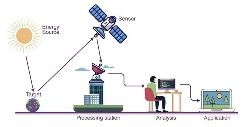
The Basics — What is Remote-Sensing?
- Remote-sensing = observing the Earth without physical contact using:
- satellites
- aircraft / drones
- ground-based sensors
- Works by analysing electromagnetic radiation (EMR) reflected or emitted by Earth-surface features.
Spectral Signatures
- Every object reflects/absorbs EMR differently.
- These reflection patterns = spectral signatures (like fingerprints).
- Sensors interpret signatures to identify:
- healthy crops vs stressed crops
- minerals vs soil
- water vs land
- vegetation types / species
Vegetation Monitoring — NDVI & Biomass
- Healthy plants:
- absorb red light (for photosynthesis)
- reflect near-infrared (NIR) (to avoid heat stress)
Normalised Difference Vegetation Index (NDVI)
- High NDVI → healthy vegetation
- Low NDVI → drought / disease stress
Evidence:
Journal of Plant Ecology (2008) — spectral data enables mapping of plant communities & forest species at landscape scale.
Applications
- crop health monitoring
- drought early warning
- forest biomass & carbon-storage estimation (climate mitigation)
Water Mapping — NDWI & SAR
Optical Water Mapping
- Water reflects visible green
- Strongly absorbs NIR & SWIR
Normalised Difference Water Index (NDWI)
→ High values over water bodies
Modified NDWI (MNDWI)
→ Better in urban areas (distinguishes water vs shadows)
Limitation
- Optical sensors fail during:
- cloud cover
- night
- storms / cyclones
Synthetic Aperture Radar (SAR)
- Active microwave sensor
- Sees through clouds & darkness
- Calm water = smooth mirror → black on radar image
→ Enables flood mapping during cyclones
Key Missions
- NASA–ISRO NISAR
- Sentinel-1 (ESA)
- RISAT series (ISRO)
Subsurface Mapping — Minerals, Oil & Gas
Hyperspectral Sensing
- Splits light into hundreds of narrow bands
- Produces per-pixel spectral fingerprints
Applications
- mineral prospecting (Cu, Au, Li)
- alteration-zone mapping
- soil & rock composition studies
Evidence:
Ore Geology Reviews (2023) — hyperspectral sensors map hydrothermal alteration zones linked to ore deposits.
Oil & Gas Exploration
Micro-seepage detection
- Hydrocarbons leaking through micro-cracks:
- alter soil chemistry
- stress vegetation → yellowing leaves
- Satellites detect these subtle spectral anomalies
Structural Mapping
Anticlines / Dome-fold traps
- Surface folds suggest similar subsurface geometry
Tools
- Landsat, ASTER (NASA) → structural imaging
- Bathymetry via ocean-surface gravity anomalies
- Magnetometry → detects depth of magnetic basement rocks
Satellites don’t say “oil is here”, but “this structure can hold oil”.
Groundwater Mapping — GRACE Mission
- Large aquifers exert stronger gravitational pull
- NASA GRACE (2002–2017) used twin satellites to:
- measure distance variation caused by gravity changes
- infer groundwater volume shifts
Landmark finding (Nature, 2009)
- North India groundwater depletion detected from space
→ linked to irrigation withdrawals
Benefits of Remote-Sensing
- Faster, cheaper, low-impact exploration
- Avoids random drilling / geological disturbance
- Enables:
- precision agriculture
- climate monitoring
- disaster management
- resource conservation
Environmental Value
- helps ensure resources are not over-exploited
- supports sustainable groundwater & forest management
Limitations
- Requires ground-truth validation
- Interpretation depends on:
- atmospheric conditions
- sensor resolution
- calibration accuracy
- Cannot detect resources directly — only indicators


