Contents
- Typhoon Goni and Typhoon Molave
- Aegean Sea earthquake strikes Turkey
- Rudram missile to be inducted by 2022
- PLFS: Dip in urban unemployment rate before lockdown
- CPCB on Environment Plan for Railway Stations
- Protection from imports time bound
TYPHOON GONI AND TYPHOON MOLAVE
Focus: GS-I Geography, GS-III Disaster Management
Why in news?
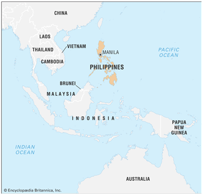
- Philippine officials ordered evacuation of thousands of residents in the southern part of the main Luzon island as a category 5 storm – Typhoon Goni – that is the world’s strongest in 2020 approaches the Southeast Asian nation.
- Recently Typhoon Molave in October 2020 killed 22 people, mostly through drowning in provinces south of the capital Manila, which is also in the projected path of Goni, the 18th tropical storm in the country.
Details
- Typhoon Goni, with 215 kph sustained winds and gusts of up to 265 kph will make landfall as the strongest typhoon to hit the Philippines since Haiyan that killed more than 6,300 people in November 2013.
- Pre-emptive evacuations have started in coastal and landslide-prone communities.
- Authorities are facing another hurdle as social distancing needs to be imposed in evacuation centres to prevent the spread of coronavirus. Typhoon Goni, moving westward from the Pacific Ocean, will bring intense rains over the capital of Philippines (Manila) and 14 provinces nearby, threatening of floods and landslides.
- Another typhoon, Atsani, is gaining strength just outside the Philippines.
- Around 20 typhoons hit the Philippines every year.
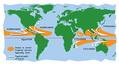
Tropical cyclone
A tropical cyclone is a rapidly rotating storm system characterized by a low-pressure center, a closed low-level atmospheric circulation, strong winds, and a spiral arrangement of thunderstorms that produce heavy rain or squalls.
Depending on its location and strength, a tropical cyclone is referred to by different names:
- Cyclones in the Indian Ocean
- Hurricanes in the Atlantic
- Typhoons in the Western Pacific and the South China Sea
- Willy-willies in Western Australia
“Tropical” refers to the geographical origin of these systems, which form almost exclusively over tropical seas.
- “Cyclone” refers to their winds moving in a circle, whirling round their central clear eye, with their winds blowing counterclockwise in the Northern Hemisphere and clockwise in the Southern Hemisphere.
- The opposite direction of circulation is due to the Coriolis effect.
How are Cyclones Formed?
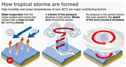
- Tropical cyclones typically form over large bodies of relatively warm water. Warm water > Evaporation > Rising up of air > Low Pressure area.
- They derive their energy through the evaporation of water from the ocean surface, which ultimately re-condenses into clouds and rain when moist air rises and cools to saturation.
- Water takes up heat from the atmosphere to change into vapour.
- When water vapour changes back to liquid form as raindrops, this heat is released to the atmosphere.
- The heat released to the atmosphere warms the air around.
- The air tends to rise and causes a drop in the pressure.
- More air rushes to the centre of the storm.
- This cycle is repeated.
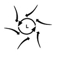
Why are Cyclones formed in a spiralling pattern?
- Simple answer is: Coriolis Effect.
- The Coriolis Effect causes any moving body on the rotating Earth to turn to the Right (clockwise) in the Northern Hemisphere and to the Left (counter clockwise) in the Southern Hemisphere.
- In Low-Pressure zones where air ascends, like in case of a cyclone, winds blowing from areas of high pressure inside towards areas of low pressure, are Deflected to the Right in Northern Hemisphere and to the Left in the Southern Hemisphere.
- Since they are deflected, they don’t arrive straight into the low-pressure zone, but instead end up circling around the low-pressure zone.
What is a Low-pressure area?
- A low-pressure area, low area or low is a region on the topographic map where the air pressure is lower than that of surrounding locations.
- Low-pressure systems form under areas of wind divergence that occur in the upper levels of the atmosphere.
- The formation process of a low-pressure area is known as cyclogenesis.
- Within the field of meteorology, atmospheric divergence aloft occurs in two areas.
- The first area is on the east side of upper troughs, which form half of a Rossby wave within the Westerlies (a trough with large wavelength that extends through the troposphere).
- A second area of wind divergence aloft occurs ahead of embedded shortwave troughs, which are of smaller wavelength.
- Diverging winds aloft ahead of these troughs cause atmospheric lift within the troposphere below, which lowers surface pressures as upward motion partially counteracts the force of gravity.
How are Low-Pressure Areas formed?
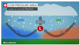
- Thermal lows form due to localized heating caused by greater sunshine over deserts and other land masses.
- Since localized areas of warm air are less dense than their surroundings, this warmer air rises, which lowers atmospheric pressure near that portion of the Earth’s surface.
- Large-scale thermal lows over continents help drive monsoon circulations.
- Low-pressure areas can also form due to organized thunderstorm activity over warm water.
Structure of a Cyclone
- A cyclone’s center, known in a mature tropical cyclone as the eye, is the area of lowest atmospheric pressure in the region.
- Near the center, the pressure gradient force and the force from the Coriolis effect must be in an approximate balance, or the cyclone would collapse on itself as a result of the difference in pressure.
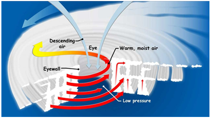
The eye
- The eye of the storm is the centre. It’s a relatively calm space.
- When the eye passes over an area, winds slow down and everything feels like it has cleared up.
- But this is the proverbial calm before the storm, as the part that comes after the eye usually inflicts the most damage.
The eyewall
- This is where the most effective part of a cyclone rests.
- The eyewall houses extremely high wind speeds, causing damage to both lives and property.
- It is a ring of thunderstorms, and changes in the eye or the eyewall affects the storm’s intensity.
Rainbands
- These are the outer parts of a cyclone where sudden bursts of rain happen.
- There can also be gaps betwen rainbands where no rain or wind occurs.
Landfall, what happens when a Cyclone reaches land from the ocean?
- Tropical cyclones dissipate when they can no longer extract sufficient energy from warm ocean water.
- A storm that moves over land will abruptly lose its fuel source and quickly lose intensity.
- A tropical cyclone can contribute to its own demise by stirring up deeper, cooler ocean waters. tropical cyclone can contribute to its own demise by stirring up deeper, cooler ocean waters.
-Source: The Hindu
AEGEAN SEA EARTHQUAKE STRIKES TURKEY
Focus: GS-I Geography, GS-III Disaster Management
Why in news?
- At least 14 people were killed in Turkey and Greece after a strong earthquake struck the Aegean Sea in October 2020, bringing buildings crashing down and setting off tidal waves which slammed into coastal areas and islands.
- The Earthquake struck with a magnitude of up to 7.0.
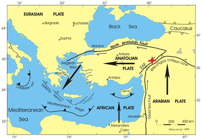
Turkey and Earthquakes
- Crisscrossed by major fault lines, Turkey is among the most earthquake-prone countries in the world.
- More than 17,000 people were killed in 1999 when a 7.6 magnitude quake struck Izmit, a city southeast of Istanbul.
- In 2011, a quake in the eastern city of Van killed more than 500.
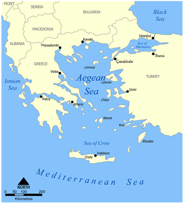
Aegean Sea
- The Aegean Sea is an elongated embayment of the Mediterranean Sea located between the Greek and Anatolian peninsulas.
- In the north, the Aegean is connected to the Marmara Sea and the Black Sea by the straits of the Dardanelles and the Bosphorus.
- The Aegean Islands are located within the sea and some bound it on its southern periphery, including Crete and Rhodes.
- The Thracian Sea and the Myrtoan Sea are subdivisions of the Aegean Sea.
- The Aegean Sea has been historically important, especially in regards to the civilization of Ancient Greece, who inhabited the area around the coast of the Aegean and the Aegean islands.
- The rocks making up the floor of the Aegean are mainly limestone, though often greatly altered by volcanic activity that has convulsed the region in relatively recent geologic times.
Earthquake
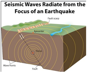
- An earthquake is shaking of the earth. It is a natural event. It is caused due to release of energy, which generates waves that travel in all directions.
- The release of energy occurs along a fault. Rocks along a fault tend to move in opposite directions. This causes a release of energy, and the energy waves travel in all directions.
- The point where the energy is released is called the focus of an earthquake, alternatively, it is called the hypocentre.
- The point on the surface, nearest to the focus, is called epicentre. It is the first one to experience the waves. It is a point directly above the focus.
Earthquake Waves
All the natural earthquakes take place in the lithosphere.
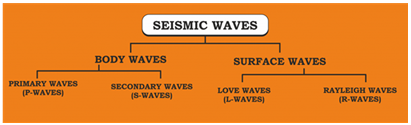
Earthquake waves are basically of two types Body Waves and Surface Waves.
Body waves
- Body Waves are generated due to the release of energy at the focus and move in all directions travelling through the body of the earth.
- There are 2 types of body waves and they are, Primary waves [P] and Secondary [S] waves.
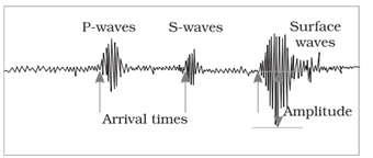
- Primary waves are the first to appear on the surface and hence the name P waves.
- P-waves vibrate parallel to the direction of the wave.
- This exerts pressure on the material in the direction of the propagation.
- P waves can travel through gaseous, liquid and solid materials.
- Secondary waves (S waves) appear after P waves.
- The direction of vibrations of S-waves is perpendicular to the wave direction in the vertical plane.
- Hence, they create troughs and crests in the material through which they pass.
Surface waves
- The body waves interact with the surface rocks and generate new set of waves called surface waves. These waves move along the surface.
- The velocity of waves changes as they travel through materials with different densities. The denser the material, the higher is the velocity.
- Their direction also changes as they reflect or refract when coming across materials with different densities.
- Surface waves are considered to be the most damaging waves.
Measurement of earthquakes
The earthquake events are scaled either according to the magnitude or intensity of the shock.
- Richter scale – The magnitude scale is known as the Richter scale. The magnitude relates to the energy released during the quake. The magnitude is expressed in absolute numbers, 0-10.
- Mercalli scale – The intensity scale is named after Mercalli, an Italian seismologist. The intensity scale takes into account the visible damage caused by the event. The range of intensity scale is from 1-12.
- Medvedev–Sponheuer–Karnik scale – This is a macroseismic intensity scale used to evaluate the severity of ground shaking on the basis of observed effects in an area of the earthquake occurrence.
-Source: The Hindu, Hindustan Times
RUDRAM MISSILE TO BE INDUCTED BY 2022
Focus: GS-III Science and Technology, Internal Security Challenges
Why in news?
- India’s first anti-radiation missile ‘Rudram’ will be ready for induction into service by 2022 and will boost the Indian Air Force’s capabilities to knock out enemy radars and surveillance systems.
- The indigenous missile, being developed by the Defence Research and Development Organisation (DRDO) for the IAF, was tested for the first time in the anti-radiation mode from a Sukhoi-30 fighter jet.
Rudram Missile
- The Rudram-1 (previously referred as DRDO Anti-Radiation Missile (ARM)) is an air-to-surface anti-radiation missile in development by Defence Research and Development Organisation.
- It is primarily meant for suppression of enemy air defenses (SEAD), that can be launched from a range of altitudes with large standoff distance for destroying enemy surveillance radars, tracking and communication systems.
- It is first anti-radiation missile to be developed in India and will be jointly produced by Bharat Dynamics Limited (BDL) and Bharat Electronics Limited (BEL) after trials and introduction.
What is an anti-radiation missile?
- Anti-radiation missiles are designed to detect, track and neutralise the adversary’s radar, communication assets and other radio frequency sources, which are generally part of their air defence systems.
- Such a missile’s navigation mechanism comprises an inertial navigation system — a computerised mechanism that uses changes in the object’s own position — coupled with GPS, which is satellite-based.
- For guidance, it has a “passive homing head” — a system that can detect, classify and engage targets (radio frequency sources in this case) over a wide band of frequencies as programmed.
- Officials said once the Rudram missile locks on the target, it is capable of striking accurately even if the radiation source switches off in between.
How significant are such missiles in aerial warfare?
- Rudram has been developed for the IAF’s requirement to enhance its Suppression of Enemy Air Defence (SEAD) capability.
- As one of the many aspects of SEAD tactics, anti-radiation missiles are used mainly in the initial part of air conflict to strike at the air defence assets of the enemy, and also in later parts, leading to higher survivability to a country’s own aircraft.
- Neutralising or disrupting the operations of the adversary’s early warning radars, command and control systems, surveillance systems that use radio frequencies and give inputs for anti-aircraft weaponry, can be very crucial.
- Scientists said modern-day warfare is more and more network-centric, which means it comprises elaborate detection, surveillance and communication systems that are integrated with the weapons systems.
-Source: Hindustan Times
PLFS: DIP IN URBAN UNEMPLOYMENT RATE BEFORE LOCKDOWN
Focus: GS-III Indian Economy
Why in news?
- Statistics from the latest Periodic Labour Force Survey (PLFS) for the quarter ending December 2019 show that the urban unemployment rate had been declining for four consecutive quarters.
- India’s labour market was beginning to look up, despite a deceleration in GDP growth, before the Covid-19 pandemic forced a lockdown in March.
Highlights
- The urban unemployment was 7.9% in the quarter ending December 2019, compared to 9.9% in the same period the previous year. This is in keeping with the trend of a decline in the unemployment rate in the quarters ending June 2019 and September 2019 as well.
- However, state-wise data showed that urban unemployment rate was higher than the national average in Uttar Pradesh, Uttarakhand, Telangana, Kerala, Madhya Pradesh, Jammu & Kashmir, Delhi and Andhra Pradesh.
- Female unemployment rate decreased to 9.8% in October-December 2019 compared to 12.3% in October-December 2018.
- Male unemployment rate moderated to 7.3% in October-December 2019 from 9.2% in October-December 2018.
- Labour Force Participation Rate rose to 37.2% in October-December 2019 from 36.3% in October-December 2018.
Periodic Labour Force Survey (PLFS)
PLFS is India’s first computer-based survey launched by the National Statistical Office (NSO) in 2017.
It has been constituted based on the recommendation of a committee headed by Amitabh Kundu.
PLFS has two-fold objective:
- To estimate the key employment and unemployment indicators (viz. Worker Population Ratio, Labour Force Participation Rate, Unemployment Rate) in the short time interval of three months for the urban areas only in the Current Weekly Status (CWS).
- To estimate employment and unemployment indicators in both usual status and CWS in both rural and urban areas annually.
Before PLFS, the NSSO (previous name of NSO) used to bring the data related to employment and unemployment based on its quinquennial (every 5 year) household socio-economic survey programme.
-Source: Hindustan Times
CPCB ON ENVIRONMENT PLAN FOR RAILWAY STATIONS
Focus: GS-III Environment and Ecology
Why in news?
The Central Pollution Control Board (CPCB) has “insisted” that the Ministry of Railways devise a modern environmental management plan to control air, water and noise pollution at major railway stations.
Details
- The CPCB had called for the formation of a joint committee comprising Railway and State government/local body officials to ensure basic civic amenities and improve environment conditions at Class-I stations.
- The move follows a recent high-level meeting convened by the CPCB involving top officials of the Ministry of Railways and the Ministry of Housing & Urban Development.
- The Railways in turn requested the CPCB to assign due weightage to different components/parameters in the template for environment performance based on rating of railway stations that are currently under review by the CPCB.
- However, the central agency insisted on developing a modern environmental plan to address issues relating to air, water and noise pollution in each of the 720 stations taken up for assessment across the country.
- Joint inspections conducted by the Central and State pollution control authorities at select stations in the last two years revealed that a majority of them had not complied with the green norms under various statutory rules of the CPCB.
These stations had not obtained necessary approvals under the
- Water (Prevention and Control of Pollution) Act, 1974,
- Air (Prevention and Control of Air Pollution) Act, 1981,
- Environment (Protection) Act, 1986
which was also insisted upon by the National Green Tribunal.
Way Forward
- The CPCB in its report mentioned the information and data needed for carrying out such a study was inadequate, preventing it to perform a complete adequacy study of the system.
- The CPCB, however, helped bring this information — which otherwise could not be traced — in the public domain.
- Railway stations need to gear up in this direction and are required to create a separate department that looks into the aspect of environmental management at railway premises.
- The performance of 36 stations is not acceptable at the current stage and requires considerable improvement.
- This study was conducted for only five per cent of 720 stations, with similar studies required for the remaining stations as well.
- The performance improvement for these stations is the need of the hour so this can be replicated in other stations as well.
-Source: The Hindu, Down to Earth Magazine
PROTECTION FROM IMPORTS TIME BOUND
Focus: GS-III Indian Economy
Why in news?
Any tariff protection to promote local manufacturing in India will come with an in-built sunset clause, NITI Aayog Vice-Chairman said, asserting that the country’s self-reliance mission must not be equated to it becoming a ‘protectionist’, closed economy.

Details
- The government is set to extend the production-linked incentive scheme for manufacturing pharmaceuticals, medical devices and electronics announced under the AtmaNirbhar Bharat package, to six more sectors.
- The NITI Aayog Vice-Chairman emphasised that India’s efforts towards self-reliance are not dissimilar to what other nations are doing to insulate themselves from global supply chain shocks and revive the economy.
- India has recently barred the import of several products, ranging from split air-conditioners to certain types of television sets and tyres, while imposing higher import duties or restrictions on import of several items.
- COVID-19 has exposed how many countries had paid little attention to social sector spending on health, education and nutrition.
-Source: The Hindu


