CONTENTS
- New Study Advocates for Category 6 Hurricane Classification
- Jobs for Resilience Report
- UNEP and WRAP Release Food Waste Index Report 2024
- Ukraine Reports Russian Use of Hypersonic Missiles in Kyiv Attacks
- Havana Syndrome
- Deadly Tornado Hits Mainaguri, West Bengal: Five Dead and Over 100 Injured
- Swell Waves
New Study Advocates for Category 6 Hurricane Classification
Context:
A recent study published in the Proceedings of the National Academy of Sciences proposes the addition of a Category 6 to the existing hurricane wind scale. Researchers assert that hurricane wind speeds can exceed 309 km/hour, suggesting that the current scale’s highest category, Category 5, may not adequately represent the extreme wind speeds experienced in the most powerful hurricanes.
Relevance:
GS I: Geography
Dimensions of the Article:
Key Highlights of the Study on the Saffir-Simpson (SS) Hurricane Wind Scale
Key Highlights of the Study on the Saffir-Simpson (SS) Hurricane Wind Scale
Concerns with the SS Hurricane Wind Scale:
- There are concerns regarding the adequacy of the SS Hurricane Wind Scale, used for over 50 years, which communicates hurricane risk based solely on wind speed.
SS Scale Categories:
- The scale comprises five categories, ranging from category 1 to category 5, with category 5 having wind speeds exceeding 252 km/hour.
- A category 5 hurricane, with combined effects of wind, storm surge, and rainfall, would completely destroy any structure.
Need for a Category 6 Cyclone:
- Due to global warming, there’s a proposal to introduce a category 6 to the SS Wind Scale to better represent the increasing risk of hurricane damage.
- Category 6 would have wind speeds above 309 km/hour.
Impact of Global Warming on Cyclones:
- Warming has not only affected the sea surface but also increased ocean depths’ temperatures, intensifying tropical cyclones.
- Earth has warmed by approximately 1.10 degrees Celsius since pre-industrial times.
- With every degree of warming, the strongest cyclones become 12% stronger, making them 40% more destructive.
- Warmer oceans lead to cyclones strengthening faster and spending more time over oceans. For instance, tropical cyclone Freddy in 2023 spent a record 37 days over the oceans.
Revising Risk Messaging:
- The study emphasizes the necessity of updating risk communication to reflect the increased risk of major hurricanes due to global warming.
- The SS Scale falls short in addressing issues like inland flooding and storm surge, crucial components of hurricane risk.
- There’s a need for more comprehensive messaging beyond wind-based scales to convey the full range of hurricane hazards.
What are Tropical Cyclones?
- The Tropical Cyclones are violent storms that originate over oceans in tropical areas and move over to coastal areas bringing about large-scale destruction caused by violent winds, very heavy rainfall and storm surges.
- These are low pressure weather systems in which winds equal or exceed speeds of 62kmph.
- Winds circulate around in anti-clockwise direction in the Northern Hemisphere and in clockwise direction in the Southern Hemisphere.
- “Tropical” refers to the geographical origin of these systems, which form almost exclusively over tropical seas.
- “Cyclone” refers to their winds moving in a circle, whirling round their central clear eye, with their winds blowing counter clockwise in the Northern Hemisphere and clockwise in the Southern Hemisphere.
- The opposite direction of circulation is due to the Coriolis effect.
Tropical Cyclones in India
- Tropical cyclones striking India generally originate in the eastern side of India.
- Bay of Bengal is more prone to cyclone than Arabian Sea because it gets high sea surface temperature, low vertical shear winds and has enough moisture in middle layers of its atmosphere.
- The frequency of cyclones in this region is bi-modal, i.e., Cyclones occur in the months of May–June and October–November.
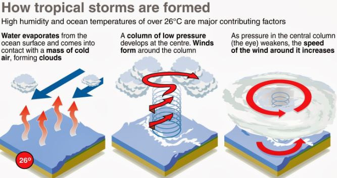
Conditions for cyclone formation:
- A warm sea surface (temperature in excess of 26o –27o C) and associated warming extending up to a depth of 60m with abundant water vapour.
- High relative humidity in the atmosphere up to a height of about 5,000 metres.
- Atmospheric instability that encourages the formation of cumulus clouds.
- Low vertical wind between the lower and higher levels of the atmosphere that do not allow the heat generated and released by the clouds to get transported from the area.
- The presence of cyclonic vorticity (rate of rotation of air) that initiates and favours rotation of the air cyclonically.
- Location over the ocean, at least 4–5 o latitude away from the equator.
How are Tropical Cyclones Formed?
- Tropical cyclones typically form over large bodies of relatively warm water. Warm water > Evaporation > Rising up of air > Low Pressure area.
- They derive their energy through the evaporation of water from the ocean surface, which ultimately re-condenses into clouds and rain when moist air rises and cools to saturation.
- Water takes up heat from the atmosphere to change into vapour.
- When water vapour changes back to liquid form as raindrops, this heat is released to the atmosphere.
- The heat released to the atmosphere warms the air around.
- The air tends to rise and causes a drop in the pressure.
- More air rushes to the centre of the storm.
- This cycle is repeated.
Why tropical cyclones don’t form in the eastern tropical oceans?
- The depth of warm water (26-27°C) should extend for 60-70 m from surface of the ocean/sea, so that deep convection currents within the water do not churn and mix the cooler water below with the warmer water near the surface.
- The above condition occurs only in western tropical oceans because of warm ocean currents (easterly trade winds pushes ocean waters towards west) that flow from east towards west forming a thick layer of water with temperatures greater than 27°C. This supplies enough moisture to the storm.
- The cold currents lower the surface temperatures of the eastern parts of the tropical oceans making them unfit for the breeding of cyclonic storms.
- ONE EXCEPTION: During strong El Nino years, strong hurricanes occur in the eastern Pacific. This is due to the accumulation of warm waters in the eastern Pacific due to weak Walker Cell.
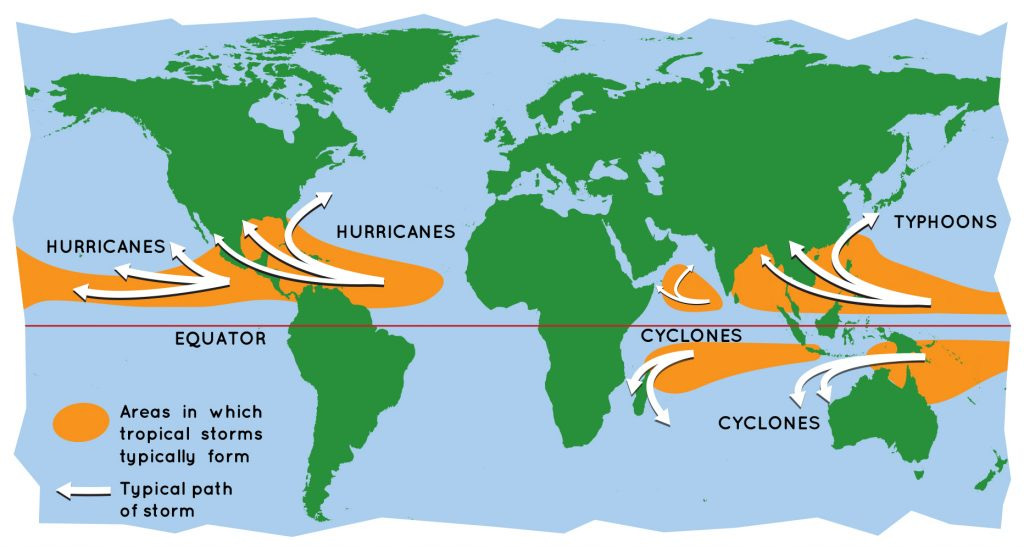
Names of Tropical Cyclones
Depending on its location and strength, a tropical cyclone is referred to by different names:
- Cyclones in the Indian Ocean
- Hurricanes in the Atlantic
- Typhoons in the Western Pacific and the South China Sea
- Willy-willies in Western Australia
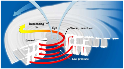
Structure of the tropical cyclone
Tropical cyclones are compact, circular storms, generally some 320 km (200 miles) in diameter, whose winds swirl around a central region of low atmospheric pressure. The winds are driven by this low-pressure core and by the rotation of Earth, which deflects the path of the wind through a phenomenon known as the Coriolis force. As a result, tropical cyclones rotate in a counter clockwise (or cyclonic) direction in the Northern Hemisphere and in a clockwise (or anticyclonic) direction in the Southern Hemisphere.
- The Eye: A characteristic feature of tropical cyclones is the eye, a central region of clear skies, warm temperatures, and low atmospheric pressure. Typically, atmospheric pressure at the surface of Earth is about 1,000 millibars.
- The Eyewall: The most dangerous and destructive part of a tropical cyclone is the eyewall. Here winds are strongest, rainfall is heaviest, and deep convective clouds rise from close to Earth’s surface to a height of 15,000 metres.
- Rainbands: These bands, commonly called rainbands, spiral into the centre of the storm. In some cases the rainbands are stationary relative to the centre of the moving storm, and in other cases they seem to rotate around the centre.
Landfall, what happens when a Cyclone reaches land from the ocean?
- Tropical cyclones dissipate when they can no longer extract sufficient energy from warm ocean water.
- A storm that moves over land will abruptly lose its fuel source and quickly lose intensity.
- A tropical cyclone can contribute to its own demise by stirring up deeper, cooler ocean waters. tropical cyclone can contribute to its own demise by stirring up deeper, cooler ocean waters.
Cyclone Management in India
India is highly vulnerable to natural disasters especially cyclones, earthquakes, floods, landslides, and drought. Natural disasters cause a loss of 2% of GDP every year in India. According to the Home ministry, 8% of total area in India is prone to cyclones. India has a coastline of 7,516 km, of which 5,700 km are prone to cyclones of various degrees.
- Loss due to cyclones: Loss of lives, livelihood opportunities, damage to public and private property and severe damage to infrastructure are the resultant consequences, which can disrupt the process of development
- Indian Meteorological Department (IMD) is the nodal agency for early warning of cyclones and floods.
- Natural Disaster Management Authority is mandated to deal with the disaster management in India. It has prepared National Guidelines on Management of Cyclone.
- National Cyclone Risk Mitigation Project (NCRMP) was launched by Home ministry to upgrade the forecasting, tracking and warning about cyclones in states.
- National Disaster Response Force (NDRF) has done a commendable performance in rescuing and managing relief work.
- National Disaster Response Reserve (NDRR)– a fund of 250 crores operated by NDRF for maintaining inventory for an emergency situation.
- In 2016, a blueprint of National Disaster Management Plan was unveiled to tackle disaster. It provides a framework to deal with prevention, mitigation, response and recovery during a disaster. According to the plan, Ministry of earth science will be responsible for disaster management of cyclone. By this plan, India joined the list of countries which follow the Sendai Framework for Disaster Risk Reduction 2015-2030.
- Due to increased awareness and tracking of Cyclone, the death toll has been reduced substantially. For example, Very severe cyclone Hudhud and Phailin claimed lives of around 138 and 45 people respectively, which might have been more. It was reduced due to the early warning and relocation of the population from the cyclone-hit areas. Very severe cyclone Ockhi claimed many lives of people in Tamil Nadu and Kerala. This was due to the unprecedented change in the direction of the cyclone.
- But the destruction of infrastructure due to cyclonic hit is not been reduced which leads to increase in poverty due to the economic weakening of the affected population.
-Source: The Hindu
Jobs for Resilience Report
Context:
The World Bank’s ‘South Asia Regional Update: Jobs for Resilience report’ raises concerns over the South Asia region, including India, failing to capitalize on its demographic dividend. Despite projecting a robust growth rate of 6.0-6.1% for 2024-25, the report indicates that the pace of job creation in the region is insufficient compared to the growth in the working-age population. This mismatch suggests a missed opportunity to fully leverage the potential economic benefits of a youthful and growing workforce in South Asia.
Relevance:
GS III: Indian Economy
Dimensions of the Article:
- Key Highlights from the Jobs for Resilience Report
- Risks Highlighted in the Report
- Case of India
- Way Ahead Suggested in the Jobs for Resilience Report for India
Key Highlights from the Jobs for Resilience Report:
Economic Growth:
- South Asia’s output growth is projected at 6.0-6.1% for 2024-25, surpassing other emerging markets and developing economies (EMDE).
- Strong growth is primarily driven by India, while growth in the rest of the region remains below pre-pandemic levels.
- The public sector is the main growth driver in South Asia, with weak private investment.
Vulnerabilities and Risks:
- Despite growth, South Asia faces underlying vulnerabilities leading to potential downside risks.
- Private investment growth has slowed significantly across all South Asian countries, hindering development and climate goals.
- South Asia’s fiscal limitations constrain public policies for climate change adaptation.
- This results in increased burdens on firms, farmers, and vulnerable households due to climate shocks.
Labour Market:
- South Asia’s labour market challenges are notable among EMDEs.
- Employment ratios are declining, and there’s a low share of women in employment.
- The agriculture sector has reduced labour, while non-agriculture sectors struggle to create jobs.
- Challenges in the economic and institutional environments have restrained firm growth.
- The region’s output growth is now heavily reliant on labour productivity and population growth, both of which are decelerating.
Risks Highlighted in the Report:
Debt and Fiscal Deficits:
- Efforts to reduce debt, borrowing costs, and fiscal deficits might constrain growth and limit responses to climate-related shocks.
Climate Adaptation:
- Providing public goods is crucial for effective climate adaptation.
- Households and farms, especially those shifting to non-agricultural jobs, benefit significantly from these public goods.
- Limited opportunities to shift from agriculture make certain adaptation strategies less effective.
Employment Trends:
- Employment challenges are more pronounced in non-agricultural sectors.
- Despite a growing working-age population, employment growth lags, preventing the region from fully utilizing its demographic potential.
- South Asia’s output growth could increase by 16% if its employment rate matched that of other EMDEs.
Case of India:
Employment Growth:
- From 2000 to 2023, India’s employment growth lagged behind its working-age population growth.
- India witnessed a significant decline in its employment ratio up to 2022, second only to Nepal in the region.
- Preliminary data for 2023 showed a 3-percentage point improvement, partially offsetting the previous decline.
Economic Growth:
- With an expected robust growth rate of 7.5% in FY23/24, India is a key driver of the strong economic performance in the South Asian region, alongside recoveries in Sri Lanka and Pakistan.
Way Ahead Suggested in the Jobs for Resilience Report for India:
Boosting Growth and Investment:
- Emphasize stronger job creation and relax financial market restrictions to enhance growth, private investment, and government revenues.
Conditions for Investment:
- Private investment is likely to increase when there’s strong institutional quality, competitive real exchange rate, and openness to trade and capital flows.
Effective Adaptation Strategies:
- Publicly supported adaptations are generally more effective.
- Policy guidance should focus on:
- Implementing comprehensive policy packages.
- Prioritizing policies with dual benefits.
- Designing policies that don’t compromise climate goals while achieving other objectives.
Sustaining Growth and Employment:
- Increase employment ratios, particularly in non-agricultural sectors and among women, by:
- Removing growth impediments for businesses.
- Enhancing openness to international trade.
- Relaxing labour and product market restrictions.
- Investing in human capital.
- Promoting equality and women’s rights.
-Source: Down To Earth
UNEP and WRAP Release Food Waste Index Report 2024
Context:
The Food Waste Index Report 2024, a collaborative effort between the United Nations Environment Programme (UNEP) and the UK-based non-profit organization WRAP (Waste and Resources Action Programme), highlights the critical need for enhancing and fortifying data infrastructure. The report emphasizes the importance of robust tracking and monitoring systems to effectively address and reduce food waste on a global scale.
Relevance:
GS III: Food Security
Dimensions of the Article:
- Key Highlights of the Food Waste Index Report
- Key Recommendations of the Food Waste Index Report 2024
Key Highlights of the Food Waste Index Report
Objective of the Report:
- The report tracks country-level progress towards halving food waste by 2030, aligning with SDG 12.3 which targets sustainable consumption and production patterns.
Scale of Food Waste in 2022:
- Globally, 1.05 billion tonnes of food were wasted in 2022.
- This constitutes 19% of the food available to consumers at the retail, food service, and household levels.
- An additional 13% of food is lost in the supply chain, from post-harvest up to but excluding retail, as estimated by FAO.
Environmental and Social Impact:
- Food loss and waste account for 8-10% of Global Greenhouse Gas (GHG) emissions, nearly five times the emissions from the aviation sector.
- This occurs while one-third of the global population faces food insecurity.
Data Trends and Disparities:
- Since the 2021 report, data coverage has expanded, leading to reduced disparities in average per capita household food waste.
- Across different income groups (high-income, upper-middle income, lower-middle income countries), household food waste levels differ by merely 7 kg per capita annually.
Factors Influencing Food Waste:
- Countries with hotter climates tend to have higher household food waste, possibly due to increased consumption of fresh foods with inedible parts and insufficient cold chain infrastructure.
- Extreme heat events, higher temperatures, and droughts complicate food storage, transportation, and sales, leading to increased wastage.
Urban vs. Rural Trends:
- Middle-income countries show differences in food waste between urban and rural areas, with rural areas generally wasting less.
- Possible reasons include better diversion of food scraps in rural settings for purposes like pet food, animal feed, and home composting.
Tracking Progress towards SDG 12.3:
- Many low- and middle-income countries lack systems to monitor progress towards halving food waste by 2030, especially in retail and food services.
- Currently, only four G-20 countries (Australia, Japan, UK, US) along with the European Union possess suitable food waste estimates for tracking progress.
Data Gaps in Key Countries:
- Countries such as India, Indonesia, and South Korea have only subnational estimates for food waste, emphasizing the need for comprehensive national data.
- The report underscores the importance of inclusive studies to gain a clearer understanding of the global food waste scenario.
Key Recommendations of the Food Waste Index Report 2024
Leadership and Cooperation:
- G20 countries should lead in international cooperation and policy development to achieve SDG 12.3.
- They should leverage their influence on global consumer trends to enhance awareness and education about food waste both domestically and globally.
Public Private Partnerships (PPPs):
- Foster the adoption of PPPs to mitigate food waste and its environmental impacts, including climate change and water stress.
- Governments, regional bodies, and industry groups should collaborate using a Target-Measure-Act approach to achieve shared objectives.
Standardized Measurement with Food Waste Index:
- Countries should employ the Food Waste Index as a consistent tool to measure food waste.
- Develop robust national baselines and continuously track progress towards achieving SDG 12.3.
- Address the current data gaps, particularly in the retail and food service sectors.
National Food Waste Studies:
- Prioritize conducting representative national food waste studies in key countries like India, China, South Africa, Indonesia, and Mexico.
- Address data discrepancies to effectively address food waste at both individual and systemic levels.
Collaborative Efforts:
- Encourage governments, cities, food businesses, and researchers to unite in reducing food waste.
- Stress the importance of precise measurement, innovative solutions, and collective action to halve global food waste by 2030 in line with SDG 12.3.
-Source: The Hindu
Ukraine Reports Russian Use of Hypersonic Missiles in Kyiv Attacks
Context:
According to Ukraine’s military administration, Russia has deployed five of its new hypersonic Zircon missiles in attacks on Kyiv since the beginning of the year. Additionally, Russia has launched 11 Kinzhal missiles, another type of hypersonic weapon known for traveling at speeds several times faster than sound. These reports underscore the increasing use and potency of advanced hypersonic weaponry in the ongoing conflict.
Relevance:
GS II: International Relations
Dimensions of the Article:
- Hypersonic Weapon Overview
- Kinzhal Overview
- Zircon Overview
Hypersonic Weapon Overview:
Definition:
- Hypersonic weapons are fast, low-flying, and highly manoeuvrable, making them challenging for traditional missile defence systems to detect and intercept.
Characteristics:
- They do not follow a fixed, arched trajectory like ballistic missiles.
- Can manoeuvre unpredictably during flight.
- Operate at speeds faster than five times the speed of sound, approximately 760 miles (1,220 km) per hour at sea level.
- The extreme speeds cause ionization of the air molecules around the missile, subjecting it to high atmospheric stresses.
Types of Hypersonic Weapons:
- Glide Vehicles: Launched using rockets, they glide towards their targets due to the difficulties of achieving sustained hypersonic propulsion.
- Cruise Missiles: Equipped with scramjet engines, these missiles use atmospheric oxygen to generate thrust, enabling them to maintain a constant speed and altitude.
Countries with Hypersonic Capabilities:
- Advanced Capabilities: US, China, and Russia.
- Research & Development: India, Japan, Australia, and France.
- Claims: North Korea has claimed successful tests of hypersonic missiles.
India’s Hypersonic Weapon Development:
- Current Status:
- India is progressing towards integrating hypersonic weapons into its military arsenal.
- Milestones:
- In 2020, India conducted a successful test of its Hypersonic Technology Demonstrator Vehicle (HSTDV) powered by a scramjet engine.
- Future Outlook:
- The HSTDV serves as a foundational step in developing long-range hypersonic weapons.
- Anticipated timeline: Four to five years for operational deployment of advanced hypersonic weapons.
Kinzhal Overview:
- Type:
- Air-launched hypersonic missile.
- Specifications:
- Range: 1,500-2,000 km.
- Speed:
- Rapidly accelerates to Mach 4 (4,900 km/h) post-launch.
- Potential speeds up to Mach 10 (12,350 km/h).
- Payload:
- Capable of carrying a nuclear payload weighing 480 kg, which is 33 times the yield of the Hiroshima atomic bomb.
- Capabilities:
- Designed to overcome air-defence systems due to its high speed, erratic flight trajectory, and manoeuvrability.
- Its hypersonic speed and trajectory make interception challenging.
Zircon Overview:
- Type:
- Sea-launched hypersonic cruise missile.
- Specifications:
- Range: 1,000 km.
- Speed:
- Travels at nine times the speed of sound, making it exceptionally fast.
- Engine:
- Powered by a scramjet engine.
- The scramjet utilizes the supersonic airflow and its compression to generate forward thrust.
- Capabilities:
- If Russian claims are accurate, Zircon could potentially bypass advanced air defence systems like the US Patriot due to its hypersonic speed, which reduces reaction time for defence systems.
- Carries a warhead weighing approximately 300 kg.
-Source: Indian Express
Havana Syndrome
Context:
Recently, there has been a noticeable surge in interest in the Havana Syndrome, particularly concerning its occurrence among US diplomats.
Relevance:
Facts for prelims
Key Points on the Havana Syndrome and Microwave Weapons
Havana Syndrome Incident:
- In late 2016, US diplomats and their employees in Havana, Cuba, reported unusual symptoms during their stay.
- Symptoms included odd physical sensations, hearing peculiar sounds, leading to sickness.
- The US accused Cuba of sonic attacks, but Cuba denied any involvement or knowledge of such illness.
Research and Symptoms:
- Multiple institutions have researched the Havana syndrome’s cause.
- Symptoms include nausea, severe headaches, fatigue, dizziness, sleep problems, and hearing loss.
- Some affected individuals experienced chronic issues like vestibular processing and cognitive problems.
Microwave Weapons and DEW:
- Direct Energy Weapons (DEW) are direct energy weapons focusing highly concentrated energy, like sonic, laser, or microwaves, at a target.
- They emit electromagnetic radiations causing sensations in the human body.
- The radiation heats the water in the human body, leading to dizziness and nausea.
Countries with Microwave Weapons:
- Several countries are believed to possess these weapons targeting both humans and electronic systems.
- China showcased its microwave weapon, Poly WB-1, at an air show in 2014.
- The US developed the “Active Denial System,” a prototype microwave-style weapon, described as the first non-lethal, directed-energy, counter-personnel system with an extended range.
India’s Directed Energy Weapons Plans:
- The Defence Research and Development Organisation (DRDO) announced plans to develop DEWs using high-energy lasers and microwaves.
- The development is crucial considering India’s deteriorating security environment, especially concerning its relationship with China.
Concerns:
- Microwave weapons pose a threat as they can harm both machines and humans.
- They can inflict long-term damage without leaving visible marks on the human body.
-Source: The Hindu
Deadly Tornado Hits Mainaguri, West Bengal: Five Dead and Over 100 Injured
Context:
A devastating tornado recently hit the Mainaguri area in the Jalpaiguri district of West Bengal, lasting for approximately 10 minutes. The natural disaster resulted in the tragic loss of five lives, with more than 100 people sustaining injuries. The event highlights the destructive power of tornadoes and underscores the urgent need for preparedness and response measures in vulnerable regions.
Relevance:
GS I: Geography
About Tornado
- Definition: A tornado is a terrestrial vertical column of intensely rotating air that originates from a thunderstorm and extends to the ground. It can reach wind speeds ranging from 105 to 322 kilometres per hour.
- Appearance: The rotating column is typically connected to the cloud base or wall cloud, often manifesting as a cloud-filled “condensation funnel”. In drier conditions, tornadoes may only be visible as ground-level dirt swirls without a clear link to the overhead cloud.
- Sea Counterpart: A tornado occurring over the sea is termed as a waterspout.
- Formation: Thunderstorms and tornadoes are generated when warm, moist air collides with dry, cooler air within the context of a low-pressure system, such as a trough.
Geographical Distribution of Tornadoes
- Primary Regions: Tornadoes are most prevalent on continents within the mid-latitudes, which span between 20 and 60 degrees north and south. These occurrences are often linked to thunderstorms forming at the convergence of cold polar and warm tropical air masses.
- Hotspots: The United States, Argentina, and Bangladesh experience the highest frequency of tornadoes globally.
Measurement of Tornado Strength
- Enhanced Fujita Scale: This scale is employed to gauge the intensity of tornadoes. It assigns a ‘rating’ to each tornado based on estimated wind speeds and the resulting damage.
-Source: Indian Express
Swell Waves
Context:
Recently, swell waves inundated coastal areas in central and southern districts of Kerala.
Relevance:
GS I: Geography
About Swell Waves
- Definition: Swell waves are long-wavelength waves that form on the ocean surface, comprised of a sequence of surface gravity waves.
Formation of Swell Waves
- Cause: Swell waves are not generated by local winds. Instead, they are formed due to distant weather phenomena such as hurricanes or prolonged periods of strong gale winds.
- Energy Transfer: During these distant storms, significant energy is transferred from the atmosphere to the ocean, resulting in the creation of exceptionally high waves. These waves can travel vast distances, sometimes thousands of kilometres from the storm’s epicentre, until they reach the shoreline.
Characteristics of Swell Waves
- Frequency and Direction: Swells exhibit a narrower range of frequencies and directions compared to wind waves generated locally. This is because swell waves disperse from their origin, lose some randomness, and assume a more defined shape and direction.
- Propagation: Swell waves can travel in directions that are distinct from the wind’s direction, unlike wind-generated waves.
- Wavelength: The typical wavelength of swell waves is under 150 metres, but it can vary between different events. In extreme cases, swell waves from the most intense storms can have wavelengths exceeding 700 metres.
- Precursors: Swell waves can occur without any precursors or local wind activity, making them distinct from other wave types.
Early Warning Systems in India
- Swell Surge Forecast System: Launched by the Indian National Centre for Ocean Information Services (INCOIS) in 2020, this system provides a seven-day advance warning about swell surges, helping to mitigate potential risks and prepare coastal communities in India.
-Source: The Hindu


