CONTENTS
- Major Earthquake Strikes Taiwan: Strongest in 25 Years
- Kallakkadal
- Katchatheevu Island
- India’s Growing Solar Waste Crisis Highlighted in Recent Report
- Uttar Pradesh Board of Madarsa Education Act, 2004
- Punnett square
- PRATUSH Telescope
- Indian laurel tree
Major Earthquake Strikes Taiwan: Strongest in 25 Years
Context:
Taiwan experienced a powerful 7.2 magnitude earthquake, marking the strongest seismic event in the region in the last 25 years. The quake’s epicentre was situated a mere 18 kilometres south-southwest of Hualien County in eastern Taiwan. Being located along the Pacific “Ring of Fire,” where 90% of the world’s earthquakes occur, Taiwan remains susceptible to such natural disasters, highlighting the importance of preparedness and resilient infrastructure in the region.
Relevance:
GS-I: Geography (Geomorphology, Important Geographical Phenomenon, Earthquakes), GS-III: Disaster Management
Dimensions of the Article:
- Earthquake
- Earthquake Waves
- Earthquake zones of India
- Measurement of earthquakes
- About the Ring of Fire
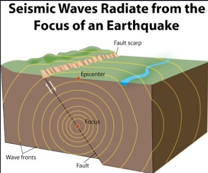
Earthquake
- An earthquake is shaking of the earth. It is a natural event. It is caused due to release of energy, which generates waves that travel in all directions.
- The release of energy occurs along a fault. Rocks along a fault tend to move in opposite directions. This causes a release of energy, and the energy waves travel in all directions.
- The point where the energy is released is called the focus of an earthquake, alternatively, it is called the hypocentre.
- The point on the surface, nearest to the focus, is called epicentre. It is the first one to experience the waves. It is a point directly above the focus.
Earthquake Waves
- All-natural earthquakes take place in the lithosphere.
- Earthquake waves are basically of two types body waves and surface waves.
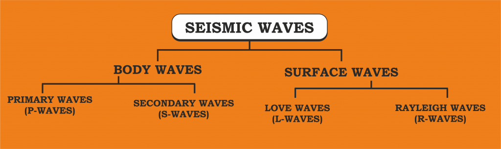
Body Waves
Body waves are generated due to the release of energy at the focus and move in all directions travelling through the body of the earth.
There are 2 types of body waves and they are, Primary waves [P] and Secondary [S] waves
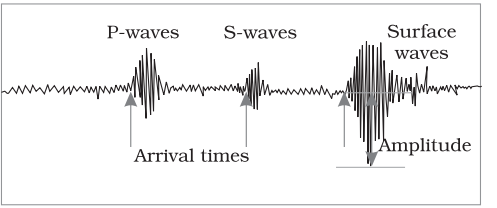
Primary waves [P]:
- Primary waves are the first to appear on the surface and hence the name P waves.
- P-waves vibrate parallel to the direction of the wave.
- This exerts pressure on the material in the direction of the propagation
- P waves can travel through gaseous, liquid and solid materials.
Secondary waves [S]:
- Secondary waves or S waves appear after P waves.
- The direction of vibrations of S-waves is perpendicular to the wave direction in the vertical plane.
- Hence, they create troughs and crests in the material through which they pass
Surface waves
- The body waves interact with the surface rocks and generate new set of waves called surface waves. These waves move along the surface.
- The velocity of waves changes as they travel through materials with different densities. The denser the material, the higher is the velocity.
- Their direction also changes as they reflect or refract when coming across materials with different densities.
- Surface waves are considered to be the most damaging waves.
Earthquake zones of India
- The major reason for the high frequency and intensity of the earthquakes is that the Indian plate is driving into Asia at a rate of approximately 47 mm/year.
- Geographical statistics of India show that more than 50% of the land is vulnerable to earthquakes.
- The latest version of seismic zoning map of India divides India into 4 seismic zones (Zone 2, 3, 4 and 5).
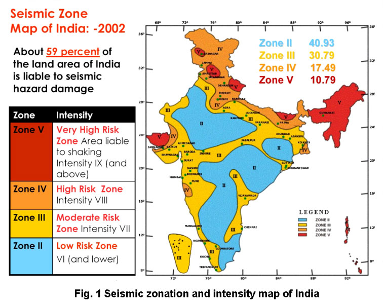
Zones of Seismicity
- Zone 1: Currently the Division does not include a Zone 1. NO area of India is classed as Zone 1.
- Zone 2: This region is liable to MSK VI or less and is classified as the Low Damage Risk Zone.
- Zone 3: This zone is classified as Moderate Damage Risk Zone which is liable to MSK VII.
- Zone 4: This zone is called the High Damage Risk Zone and covers areas liable to MSK VIII. Jammu and Kashmir, Ladakh, Himachal Pradesh, Uttarakhand, Sikkim, the parts of Indo-Gangetic plains (North Punjab, Chandigarh, Western Uttar Pradesh, Terai, North Bengal, Sundarbans) and the capital of the country Delhi fall in Zone 4.
- Zone 5: Zone 5 covers the areas with the highest risks zone that suffers earthquakes of intensity MSK IX or greater. The region of Kashmir, the Western and Central Himalayas, North and Middle Bihar, the North-East Indian region, the Rann of Kutch and the Andaman and Nicobar group of islands fall in this zone.
Measurement of earthquakes
The earthquake events are scaled either according to the magnitude or intensity of the shock.
- Richter scale – The magnitude scale is known as the Richter scale. The magnitude relates to the energy released during the quake. The magnitude is expressed in absolute numbers, 0-10.
- Mercalli scale – The intensity scale is named after Mercalli, an Italian seismologist. The intensity scale takes into account the visible damage caused by the event. The range of intensity scale is from 1-12.
- Medvedev–Sponheuer–Karnik scale – This is a macroseismic intensity scale used to evaluate the severity of ground shaking on the basis of observed effects in an area of the earthquake occurrence.
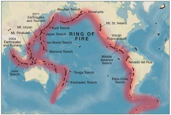
About the Ring of Fire
- Many volcanoes in the Ring of Fire were created through a process of subduction. And most of the planet’s subduction zones happen to be located in the Ring of Fire
- It is a string of at least 450 active and dormant volcanoes that form a semi-circle, or horse shoe, around the Philippine Sea plate, the Pacific Plate, Juan de Fuca and Cocos plates, and the Nazca Plate.
- There is a lot of seismic activity in the area.
- 90 per cent of all earthquakes strike within the Ring of Fire
-Source: The Hindu
Kallakkadal
Context:
Recent high sea waves, commonly referred to as swell waves or Kallakkadal in Malayalam, have caused extensive flooding in coastal areas of Kerala. Hundreds of houses in regions like Alappuzha, Kollam, and Thiruvananthapuram districts have been affected by these swell surges. The flooding highlights the vulnerability of Kerala’s coastal communities to natural events and emphasizes the need for effective disaster preparedness and response measures.
Relevance:
GS III: Disaster Management
Dimensions of the Article:
- Kallakkadal
- Challenges in Early Preparedness for Kallakkadal
- Differences Between Kallakkadal and Tsunami
Kallakkadal
Definition and Origin
- Kallakkadal refers to coastal flooding occurring during the pre-monsoon season (April-May) due to swell waves on the southwest coast of India.
- The term “Kallakkadal” originates from two Malayalam words: “Kallan,” meaning thief, and “Kadal,” meaning sea, translating to “ocean that arrives as a thief.”
- In 2012, UNESCO formally approved the term, acknowledging its significance among local fishermen.
Causes of Kallakkadal
Formation of Swell Waves
- Kallakkadal is primarily caused by waves formed through ocean swells, hence the name “swell surge.”
- These ocean swells are not generated by local winds but are a result of distant storms such as hurricanes or prolonged periods of intense gale winds.
- During these storms, a significant transfer of energy occurs from the air to the water, leading to the creation of exceptionally high waves.
- These waves can travel vast distances from the storm center until they reach the coastline.
Role of Southern Indian Ocean Winds
- Kallakkadal results from the powerful winds in the southern part of the Indian Ocean, generating ocean swells.
- These waves then travel northward, reaching the coast within two to three days.
- A recent instance occurred when a low atmospheric pressure system moved over the region around March 25, originating from the South Atlantic Ocean approximately 10,000 kilometers away from the Indian coast.
- This atmospheric pressure system caused strong winds, resulting in the formation of swell waves reaching heights of up to 11 meters.
Challenges in Early Preparedness for Kallakkadal
Lack of Precursors
- Kallakkadal often occurs without any precursors or local wind activity, making it challenging for coastal communities to receive advance warnings.
Swell Surge Forecast System
- Despite the inherent difficulties in predicting Kallakkadal, the Swell Surge Forecast System offers early warnings up to seven days in advance.
- Launched by the Indian National Centre for Ocean Information Services (INCOIS) in 2020, this system aids in providing timely alerts to coastal populations, enhancing preparedness and response measures.
Differences Between Kallakkadal and Tsunami
Nature of Occurrence
- Kallakkadal: It is a flash flood event that occurs suddenly without any noticeable change in local winds.
- Tsunami: Tsunami is a series of massive waves generated by underwater disturbances, typically earthquakes.
Cause
- Kallakkadal: It is primarily caused by strong winds.
- Tsunami: Tsunamis are predominantly caused by earthquakes, although they can also result from volcanic eruptions, landslides, or meteorite impacts.
Wave Characteristics
- Kallakkadal:
- Wave height varies based on the strength of the wind causing the swell.
- Originates due to ocean swells formed by distant storms or prolonged periods of intense gale winds.
- Tsunami:
- While tsunamis have a relatively small wave height offshore, they can gain enormous height as they approach the coast.
- Tsunamis are characterized by their long wavelength, often extending hundreds of kilometers, which distinguishes them from regular ocean waves with wavelengths of only 30 to 40 meters.
-Source: Indian Express
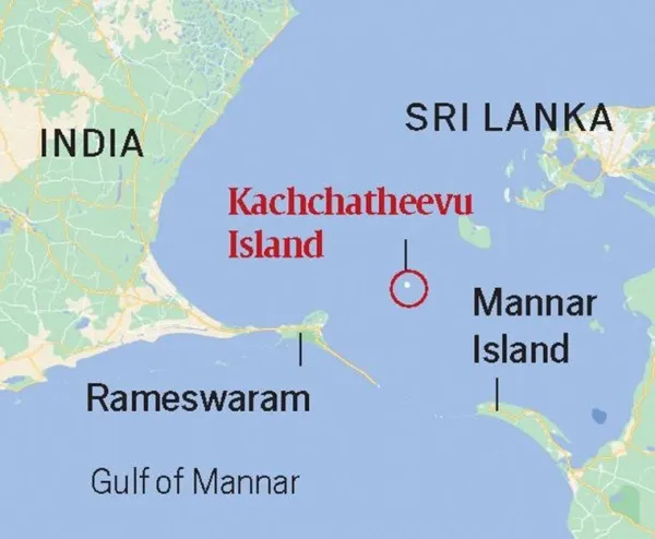
Katchatheevu Island
Context:
Katchatheevu Island has emerged as a focal point in the India-Sri Lanka relationship, particularly due to the contentious issue of fishing rights in the surrounding waters. This small but significant island exemplifies the complexities associated with maritime boundary disputes and the competing claims over fishing resources in the region. The unresolved issues concerning Katchatheevu underscore the challenges faced by both countries in managing their maritime boundaries and ensuring sustainable fishing practices.
Relevance:
GS II: International Relations
Dimensions of the Article:
- Dispute Related to Katchatheevu Island: A Comprehensive Overview
- Stakeholder Positions on the Katchatheevu Issue: An Overview
- Maritime Disputes of India with Neighbouring Nations: An Overview
Dispute Related to Katchatheevu Island: A Comprehensive Overview
Basic Facts:
- Location: Katchatheevu is a 285-acre uninhabited island situated in the Palk Strait between India and Sri Lanka.
- Geographical Position: It is located approximately 33 km northeast of Rameswaram (India) and 62 km southwest of Jaffna (Sri Lanka).
- Significance: Despite its uninhabited nature, the island hosts St. Anthony’s church, an early 20th-century Catholic shrine that attracts devotees from both India and Sri Lanka.
Historical Background:
- Formation: The island was formed due to a volcanic eruption in the 14th century.
- Early Rulers: Initially under the Jaffna kingdom of Sri Lanka, the island came under the control of the Ramnad zamindari, governed by the Nayak dynasty of Madurai in the 17th century.
Ownership Dispute:
- India’s Claim: India and Sri Lanka disputed the ownership of Katchatheevu, which was part of the Madras Presidency during British rule.
- Sri Lanka’s Claim: Sri Lanka based its sovereignty claim on the Portuguese occupation of the island from 1505 to 1658 CE.
- 1974 Agreement: The Indo-Sri Lankan Maritime Agreement of 1974 transferred the island’s ownership to Sri Lanka.
- 1976 Agreement: An additional accord prohibited both countries from fishing in each other’s Exclusive Economic Zones, but it failed to clarify fishing rights around Katchatheevu due to its ambiguous positioning at the boundary of these zones.
- Post-2009 Tensions: The end of Sri Lanka’s civil war in 2009 led to increased tensions over Indian fishermen entering Sri Lankan waters, resulting in arrests, allegations of custodial torture, and renewed demands by India to retrieve Katchatheevu.
Contentious Issues:
- Fishing Rights: The 1974 agreement allowed Indian fishermen to access Katchatheevu, but differing interpretations have led to ongoing disputes. Sri Lanka restricts Indian fishermen from engaging in activities like resting, drying nets, and visiting the shrine without a visa.
Stakeholder Positions on the Katchatheevu Issue: An Overview
1970s-1990s: Tamil Nadu’s Assertive Stance
- 1973: The then Chief Minister of Tamil Nadu urged the central government to retain Katchatheevu, emphasizing that the island belonged to India as a whole, not just Tamil Nadu.
- 1991: The issue gained renewed attention when another Chief Minister of Tamil Nadu called for the retrieval of Katchatheevu. The demand was later modified to seek a perpetual lease of the island. Both the Chief Minister and the Leader of the Opposition approached the Supreme Court with this demand.
2010s-2020s: Central Government’s Evolving Stance
- 2013: The Union government informed the Supreme Court that reclaiming Katchatheevu from Sri Lanka was not relevant, as no Indian territory was relinquished. The government cited historical agreements from 1974 and 1976 as settling the dispute.
- 2022: In a shift from its previous stance, the Union government, while referencing the 1974 and 1976 agreements, clarified in its reply to the Rajya Sabha that Katchatheevu “lies on the Sri Lankan side of the India-Sri Lanka International Maritime Boundary Line.”
Current Status:
- Sub Judice: The matter remains under judicial review in the Supreme Court, indicating that a final resolution to the Katchatheevu dispute is yet to be determined.
Maritime Disputes of India with Neighbouring Nations: An Overview
India-Pakistan: Sir Creek Dispute
- Nature of Dispute: The maritime boundary along Sir Creek, a 96-km tidal estuary in the Rann of Kutch region, remains a contentious issue between India and Pakistan.
- Background: The dispute stems from ambiguities in the demarcation of the boundary, particularly the issue of whether the boundary should follow the course of the creek’s main channel or its western flank.
- Status: Despite numerous bilateral discussions and attempts to resolve the issue, including joint surveys and talks by respective border security agencies, a mutually acceptable resolution remains elusive.
India-Bangladesh: New Moore Island (South Talpatti)
- Nature of Dispute: The dispute centered on New Moore Island (also known as South Talpatti) in the Bay of Bengal, claimed by both India and Bangladesh.
- Background: The island emerged in the Bay of Bengal in the aftermath of a cyclone in the 1970s, leading to competing claims based on territorial waters and continental shelf boundaries.
- Resolution: In 2014, the Permanent Court of Arbitration (PCA) ruled in favour of Bangladesh, settling the maritime boundary dispute and delineating the territorial waters, exclusive economic zones, and the continental shelf between the two nations.
-Source: The Hindu
India’s Growing Solar Waste Crisis Highlighted in Recent Report
Context:
A report titled ‘Enabling a Circular Economy in India’s Solar Industry – Assessing the Solar Waste Quantum’ has drawn attention to India’s increasing solar waste issue. The study was undertaken by the Ministry of New and Renewable Energy (MNRE) in partnership with experts from the Council on Energy, Environment and Water, a prominent not-for-profit policy research institution in Asia. This report underscores the need for sustainable solutions to manage and recycle solar waste in India’s burgeoning solar industry.
Relevance:
GS III: Indian Economy
Dimensions of the Article:
- Key Highlights of the Report
- What is Solar Waste?
- Challenges of Solar Waste Recycling in India
Key Highlights of the Report
Solar Capacity and Waste Generation
- India’s solar capacity as of FY23 has produced approximately 100 kilotonnes (kt) of cumulative waste.
- By 2030, this waste is projected to rise to 340 kt.
- A 32-fold increase is expected by 2050, leading to around 19,000 kt of cumulative waste.
- 77% of the waste anticipated by 2050 will stem from new capacities.
State-wise Waste Production
- Five states, namely Rajasthan, Gujarat, Karnataka, Tamil Nadu, and Andhra Pradesh, are predicted to account for about 67% of the projected waste by 2030.
- Rajasthan is set to generate 24% of the waste by 2030, with Gujarat contributing 16%, and Karnataka 12%.
Minerals in Discarded Solar Modules
- Discarded solar modules contain crucial minerals vital for India’s economic growth and national security.
- These minerals include silicon, copper, tellurium, and cadmium.
- The estimated 340 kt of waste by 2030 is expected to include 10 kt of silicon, 12-18 tonnes of silver, and 16 tonnes of cadmium and tellurium.
Recommendations
MNRE Database Maintenance
- The Ministry of New and Renewable Energy (MNRE) should establish and routinely update a database detailing the installed solar capacity.
- This database should encompass information like module technology, manufacturer, commissioning date, etc., to accurately pinpoint potential waste generation hubs.
Guidelines for Solar Waste Management
- The Ministry of Environment, Forest and Climate Change should formulate and release guidelines for the collection and storage of solar waste.
- Additionally, efforts should be made to promote the safe and efficient processing of this stored waste.
Responsibility of Solar Producers
- Solar cell and module manufacturers should initiate the development of waste collection and storage centers.
- This action is necessary to comply with the obligations set forth in the Electronic Waste Management Rules 2022.
What is Solar Waste?
Definition and Origin
- Solar waste encompasses waste generated during the manufacturing of solar modules and includes discarded modules and scrap from the manufacturing process.
- Modules are typically discarded either at the end of their operational life or due to damages incurred during transportation, handling, or installation.
Importance of Proper Handling
- Improper handling and disposal methods for solar waste should be avoided.
- Proper treatment is crucial to recover valuable minerals and prevent the leaching of toxic substances like lead and cadmium.
Recyclability of Solar Waste
- According to the International Renewable Energy Agency (IRENA), approximately 80% of solar panel components, including materials like glass and metal frames, are recyclable.
- Solar waste can be recycled to reclaim materials such as glass, aluminium, copper, silicon, and silver.
- Recycling methods can be categorized into mechanical, thermal, and chemical processes, each aiding in the recovery of specific minerals with varying purity grades.
Challenges of Solar Waste Recycling in India
Lack of Comprehensive Laws
- The absence of specific and comprehensive laws addressing solar waste management in India impedes the establishment of standardized recycling practices.
- This may lead to inconsistent recycling efforts across the country.
Complex Composition of Solar Panels
- Solar panels comprise diverse materials, including silicon, glass, and aluminium, along with hazardous elements like lead and cadmium.
- Effective recycling requires the separation of these components, which demands specialized technology that is often costly and not readily available in India.
Informal Recycling Practices
- A significant portion of solar waste in India is handled by informal recyclers.
- These informal sectors often lack proper safety measures and may engage in environmentally detrimental practices.
Economic Feasibility Concerns
- The insufficient demand for recycled materials, such as silicon wafers or glass cullet from solar panels, undermines the economic viability of recycling initiatives in India.
-Source: Indian Express
Uttar Pradesh Board of Madarsa Education Act, 2004
Context:
The Allahabad High Court (HC) has struck down the Uttar Pradesh Board of Madarsa Education Act, 2004, as unconstitutional.
Relevance:
GS II: Polity and Governance
Dimensions of the Article:
- Uttar Pradesh Board of Madarsa Education Act, 2004
Uttar Pradesh Board of Madarsa Education Act, 2004
Purpose and Objectives
- The Act was introduced to regulate and oversee the operations of madrasas (Islamic educational institutions) within Uttar Pradesh.
- It established a structured framework for the establishment, recognition, curriculum, and administration of these madrasas across the state.
- The Uttar Pradesh Board of Madarsa Education was set up under this Act to supervise and monitor the activities of madrasas in Uttar Pradesh.
Concerns and Criticisms Regarding the Act
Constitutional Concerns
- The Allahabad High Court (HC) has declared the Act unconstitutional, asserting that it promotes education based on religious segregation.
- Such a provision contradicts the secular principles enshrined in the Indian Constitution and fundamental rights.
Quality of Education
- Criticisms were raised about the Act’s failure to guarantee compulsory education up to the age of 14 years, as stipulated by Article 21 A of the Constitution.
- Madrasas being excluded from the Right to Education (RTE) Act, 2009 raised concerns about potentially depriving students of universal and quality school education.
Curriculum Focus
- Examination of the madrasa syllabi revealed a heavy emphasis on Islamic studies, with modern subjects receiving limited attention.
- Students were obligated to study Islamic doctrines to progress, whereas modern subjects were either optional or offered minimally.
Compatibility with Higher Education Standards
- The Act was found to be in conflict with Section 22 of the University Grants Commission (UGC) Act, 1956, raising doubts about its alignment with higher education standards.
Court’s Verdict and Recommendations
- The Allahabad HC declared the Uttar Pradesh Board of Madarsa Education Act, 2004 unconstitutional due to its violations of secular principles and fundamental rights.
- The court directed the state government to accommodate madrasa students in recognized regular schools and expressed concerns about the limited focus on Islamic studies in the curriculum.
- This ruling underscored potential negative impacts on students’ access to quality education and spurred legal discussions about constitutional infringements.
-Source: Indian Express
Punnett Square
Context:
Punnett squares are a way to predict the possible genetic outcomes of the offspring when two individuals with known genotypes are crossed.
Relevance:
Facts for Prelims
Punnett Square: An Overview
Introduction:
- Origin: The Punnett Square is named after British geneticist Reginald Punnett, who devised this simple yet effective tool for understanding genetic inheritance.
How Does It Work?
- Setup: List the possible genetic traits of one parent along the top of the grid and the other parent’s traits along the side.
- Combination: Fill in the squares by pairing each trait from one parent with the corresponding trait from the other parent.
- Outcome: Each square represents a potential combination of traits that the offspring could inherit from their parents.
Application:
- Education: Punnett Squares are frequently used in biology education to teach students about dominant and recessive genes and inheritance patterns.
- Predictive Tool: They serve as a predictive tool for determining the likelihood of specific traits appearing in offspring resulting from cross-breeding.
- Research: Researchers use Punnett Squares in conjunction with Mendelian inheritance principles to study and understand genetic traits in various organisms, including humans and animals.
-Source: The Hindu
PRATUSH Telescope
Context:
Astronomers are looking forward to opening a new window on the universe by posting high-resolution telescopes on the moon, and in orbit around it, including one from India called PRATUSH.
Relevance:
Facts for Prelims
PRATUSH Telescope Overview
Project Name and Objective
- Name: Probing ReionizATion of the Universe using Signal from Hydrogen (PRATUSH) Telescope
- Objective: PRATUSH aims to investigate the reionization era of the universe by capturing signals from hydrogen, shedding light on the early stages of cosmic evolution.
Development and Collaboration
- Lead Institution: The telescope is being constructed by the Raman Research Institute (RRI) located in Bengaluru.
- Collaboration: The Indian Space Research Organisation (ISRO) is actively collaborating with RRI in the development and launch of PRATUSH.
Launch Plan
- Initial Phase: ISRO will first position PRATUSH into an orbit around the Earth for initial adjustments and fine-tuning.
- Final Destination: After the necessary calibrations, ISRO plans to launch PRATUSH towards the moon to be stationed on its far side.
Primary Roles and Objectives
- Signal Detection: PRATUSH is designed to detect signals emitted by the first stars and galaxies, offering insights into the cosmic dawn phase of the universe.
- Key Questions: It aims to answer fundamental questions such as when the first stars formed, the characteristics of these early stars, and the nature of the light emitted by them.
Technical Specifications
- Antenna: PRATUSH will feature a wideband frequency-independent antenna capable of capturing a broad range of signals.
- Receiver: The telescope will be equipped with a self-calibrating analog receiver to enhance signal detection accuracy.
- Correlator: A digital correlator will be integrated into the system to analyze and interpret radio noise, particularly focusing on signals from the Dark Ages of the universe.
- Sensitivity: The target sensitivity of PRATUSH is set at a few millikelvin, aiming to achieve high precision in signal detection without being constrained by systematic features.
-Source: The Hindu
Indian laurel Tree
Context:
Recently, forest department authorities in Andhra Pradesh’s Alluri Sitharama Raju district cut the bark of an Indian laurel tree, with water gushing out.
Relevance:
Facts for Prelims
Indian Laurel Tree Overview
Scientific Classification
- Scientific Name: Terminalia elliptica
- Synonyms: T. tomentosa
Common and Regional Names
- Common Names: Indian laurel, Asna, Saj or Saaj
- Regional Names:
- Marutham (Tamil)
- Matti (Kannada)
- Ain (Marathi)
- Taukkyan (Burma)
- Asana (Sri Lanka)
- Nickname: Crocodile bark, due to its distinctive bark pattern resembling crocodile skin.
Natural Habitat
- Type: Found in both dry and moist deciduous forests.
- Geographical Range: Primarily located in southern India, extending up to elevations of 1000 meters.
Distribution
- Native Range: Southern and Southeast Asia, including countries like India, Nepal, Bangladesh, Myanmar, Thailand, Laos, Cambodia, and Vietnam.
Applications and Uses
- Wood Usage:
- Used in furniture making, cabinetry, joinery, paneling, specialty items, boat-building, and railroad cross-ties (when treated).
- Also employed in decorative veneers and for crafting musical instruments, such as guitar fretboards.
- Leaf Application:
- The leaves serve as a food source for Antheraea paphia (silkworms), which produce tussar silk (Tussah) – a commercially valuable form of wild silk.
- Medicinal Properties:
- The bark is utilized medicinally to treat diarrhoea.
- It also contains oxalic acid extractable for various applications.
- Industrial Uses:
- Both the bark and the fruit yield pyrogallol and catechol, which are used in leather tanning and dyeing processes.
-Source: The Hindu


