Contents:
- Clouds serve as an atmospheric blanket that controls the Earth’s surface temperature
- Nearly every child will face frequent heatwaves by 2050: UNICEF
- Cyclone Sitrang
- CCI imposes penalty on Google
Clouds serve as an atmospheric blanket that controls the Earth’s surface temperature
Context:
According to a new study, Climate change is shrinking the gap between the daily high and low temperatures in many parts of the world.
Relevance:
GS-I: Geography (Physical Geography, Climatology, Important Geophysical phenomena), GS-III: Environment and Ecology (Climate Change and its effects)
Dimensions of the Article:
- Key points
- Clouds
Key points:
Researchers attribute the asymmetry between the daily high and low temperatures to an increase in clouds during the daytime.
Increased cloud cover reduces the amount of incoming solar shortwave radiation. It pulls down the rate at which the daily maximum temperatures rise.
The difference between the two, or the diurnal temperature range (DTR), impacts — seasons, crop yields, residential energy use and heat-stress-induced ailments.
The formation of clouds affects weather and climate on all levels of the atmosphere. Precipitation is influenced by the kind and volume of clouds that frequently form over a location. Temperatures on the planet’s surface may also be impacted by cloud cover.
Additionally, clouds serve as an atmospheric blanket that controls the Earth’s surface temperature. A part of the solar energy that strikes Earth during the day is reflected back into space by clouds. This regulates the Earth’s surface temperature and prevents it from becoming too warm.
Also, clouds can behave as a blanket, trapping heat on Earth by absorbing heat emitted by the planet’s surface. They return this heat to Earth, warming the lower atmosphere.
Factors impacting local temperature:
- land-use modifications (such as deforestation),
- soil moisture,
- precipitation,
- cloud cover and so on.
Clouds play a vital role in the diurnal temperature variation by modulating solar radiative processes, which consequently affect the heat exchange at the land surface.
The daily maximum and minimum temperatures are anticipated to continue to rise due to climate change.
Hence, it is very important to know how DTR will change in the future because it modulates human, animal and plant metabolisms. It also modulates the local atmospheric circulation such as the land-sea breeze.
Clouds:
Cloud is a mass of minute water droplets or tiny crystals of ice formed by the condensation of the water vapour in free air at considerable
elevations.
- As the clouds are formed at some height over the surface of the earth, they take various shapes.
- According to their height, expanse, density and transparency or opaqueness clouds are grouped under four types
Cirrus
- Cirrus clouds are formed at high altitudes (8,000 – 12,000m). They are thin and detached clouds having a feathery appearance.
- They are always white in colour.
Cumulus
- Cumulus clouds look like cotton wool. They are generally formed at a height of 4,000 – 7,000 m.
- They exist in patches and can be seen scattered here and there. They have a flat base.
Stratus
- As their name implies, these are layered clouds covering large portions of the sky.
- These clouds are generally formed either due to loss of heat or the mixing of air masses with different temperatures.
Nimbus
- Nimbus clouds are black or dark grey. They form at middle levels or very near to the surface of the earth.
- These are extremely dense and opaque to the rays of the sun.
- Sometimes, the clouds are so low that they seem to touch the ground.
- Nimbus clouds are shapeless masses of thick vapour
-Source: Down to earth
Nearly Every Child Will Face Frequent Heatwaves by 2050: UNICEF
Context:
According to a new United Nations Children’s Fund (UNICEF) report, nearly all the world’s children will be exposed to more frequent and severe heatwaves by 2050.
Relevance:
GS III- Environment (Climate change)
Dimensions of the Article:
- Key Points
- About Heat Wave
- Criteria for Heat Waves
- Risks associated with Heatwave
- Way forward
Key points:
- Currently, some 559 million children are exposed to at least four to five hazardous heatwaves annually, according to The Coldest Year of the Rest of Their Lives report.
- The number will quadruple to over two billion by 2050 — up from 24 per cent of children in 2020. This amounts to an increase of about 1.5 billion children.
- “Virtually every child on earth” will face severe heatwaves even under a low greenhouse gas emission scenario — with an estimated 1.7 degrees celcius of warming in 2050.
- Heatwaves with longer duration pose more risks for children as they spend more time outdoors than adults for — sports and other activities — putting them at greater risk for heat injury.
- One in four children lives in areas where the average heatwave event lasts 4.7 days or longer as of 2020. This percentage will rise to over three in four children under a low-emission scenario by 2050.
- Children in southern, western and south-eastern Asia, eastern and southern Europe and northern Africa experience heatwaves of longer duration.
- Children are affected by heat in two broad ways:
- Risks to health and well-being and
- Social and educational risks
About Heat Wave
- A heat wave is a period of abnormally high temperatures, more than the normal maximum temperature that occurs during the summer season in the North-Western and South Central parts of India.
- Heat waves typically occur between March and June, and in some rare cases even extend till July.
- Higher daily peak temperatures and longer, more intense heat waves are becoming increasingly frequent globally due to climate change.
Criteria for Heat Waves
- The heat wave is considered when the maximum temperature of a station reaches at least 40°C for Plains and at least 30°C for Hilly regions.
- If the normal maximum temperature of a station is less than or equal to 40°C, then an increase of 5°C to 6°C from the normal temperature is considered to be heat wave condition.
- Further, an increase of 7°C or more from the normal temperature is considered as severe heat wave condition.
- If the normal maximum temperature of a station is more than 40°C, then an increase of 4°C to 5°C from the normal temperature is considered to be heat wave condition. Further, an increase of 6°C or more is considered as severe heat wave condition.
- Additionally, if the actual maximum temperature remains 45°C or more irrespective of normal maximum temperature, a heat wave is declared.
Risks associated with Heatwave:
- Risks to health include — heat stroke, heat stress, allergy, chronic respiratory conditions, asthma, mosquito-borne disease, cardiovascular disease, under-nutrition and diarrhoea.
- High temperatures are linked to increased mental health problems in children and adolescents, including post-traumatic stress disorder and depression.
- Risks to Education: Extreme heat affects children’s education and future livelihoods, said the UNICEF report.
- Heatwaves lead to poor health and nutrition among children and are linked to lower academic perfomance and attendance.
- High temperatures and lower hydration affect children’s ability to concentrate.
- Risks to Livelihood: Heatwaves also threaten children’s safety. Communities are forced to search for and compete over food and water resources as pastures and household income dry up. The resulting migration, displacement and conflict expose children to serious physical harm and violence risks.
Way forward:
- The UNICEF data stressed on adopting adaptation and mitigation strategies. There is a need to ensure that the vulnerable have the resources to adopt the critical social services required to protect them.
- The report said the countries must:
- Protecting children from climate devastation by encouraging social services
- Preparing children to live in a climate-changed world
- Prioritising children and youth in climate finance and resources
- Preventing a climate catastrophe by reducing greenhouse gas emissions
- Climate education is crucial in the fight against climate change
-Source: Down to earth
Cyclone Sitrang
Context:
The remnants of Cyclone Sitrang, which made landfall over Bangladesh recently, will cause widespread moderate to heavy rainfall over Assam, Arunachal Pradesh, Meghalaya, Mizoram, and Tripura.
Relevance:
GS-I: Geography (Physical geography – Climatology, Important Geophysical phenomena), GS-III: Disaster Management
Dimensions of the Article:
- Key points
- What are Tropical Cyclones?
- Conditions for cyclone formation:
- How are Tropical Cyclones Formed?
- Why tropical cyclones don’t form in the eastern tropical oceans?
- Names of Tropical Cyclones
- Structure of the tropical cyclone
- Landfall, what happens when a Cyclone reaches land from the ocean?
- Cyclone Management in India
Key points:
In Bangladesh, Sitrang left at least 35 people dead and about 8 million without power. The Bangladesh government said about 10,000 homes were damaged and more than 6,000 hectares (15,000 acres) of crops were destroyed. Thousands of fishing projects were also washed away.
The tropical storm, which moved towards Bangladesh from north Bay of Bengal at a speed of 56 kmph, caused moderate to heavy rain.
What are Tropical Cyclones?
- The Tropical Cyclones are violent storms that originate over oceans in tropical areas and move over to coastal areas bringing about large-scale destruction caused by violent winds, very heavy rainfall and storm surges.
- These are low pressure weather systems in which winds equal or exceed speeds of 62kmph.
- Winds circulate around in anti-clockwise direction in the Northern Hemisphere and in clockwise direction in the Southern Hemisphere.
- “Tropical” refers to the geographical origin of these systems, which form almost exclusively over tropical seas.
- “Cyclone” refers to their winds moving in a circle, whirling round their central clear eye, with their winds blowing counter clockwise in the Northern Hemisphere and clockwise in the Southern Hemisphere.
- The opposite direction of circulation is due to the Coriolis effect.
Tropical Cyclones in India
- Tropical cyclones striking India generally originate in the eastern side of India.
- Bay of Bengal is more prone to cyclone than Arabian Sea because it gets high sea surface temperature, low vertical shear winds and has enough moisture in middle layers of its atmosphere.
- The frequency of cyclones in this region is bi-modal, i.e., Cyclones occur in the months of May–June and October–November.
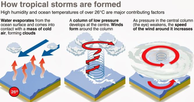
Conditions for cyclone formation:
- A warm sea surface (temperature in excess of 26o –27o C) and associated warming extending up to a depth of 60m with abundant water vapour.
- High relative humidity in the atmosphere up to a height of about 5,000 metres.
- Atmospheric instability that encourages the formation of cumulus clouds.
- Low vertical wind between the lower and higher levels of the atmosphere that do not allow the heat generated and released by the clouds to get transported from the area.
- The presence of cyclonic vorticity (rate of rotation of air) that initiates and favours rotation of the air cyclonically.
- Location over the ocean, at least 4–5 o latitude away from the equator.
How are Tropical Cyclones Formed?
- Tropical cyclones typically form over large bodies of relatively warm water. Warm water > Evaporation > Rising up of air > Low Pressure area.
- They derive their energy through the evaporation of water from the ocean surface, which ultimately re-condenses into clouds and rain when moist air rises and cools to saturation.
- Water takes up heat from the atmosphere to change into vapour.
- When water vapour changes back to liquid form as raindrops, this heat is released to the atmosphere.
- The heat released to the atmosphere warms the air around.
- The air tends to rise and causes a drop in the pressure.
- More air rushes to the centre of the storm.
- This cycle is repeated.
Why tropical cyclones don’t form in the eastern tropical oceans?
- The depth of warm water (26-27°C) should extend for 60-70 m from surface of the ocean/sea, so that deep convection currents within the water do not churn and mix the cooler water below with the warmer water near the surface.
- The above condition occurs only in western tropical oceans because of warm ocean currents (easterly trade winds pushes ocean waters towards west) that flow from east towards west forming a thick layer of water with temperatures greater than 27°C. This supplies enough moisture to the storm.
- The cold currents lower the surface temperatures of the eastern parts of the tropical oceans making them unfit for the breeding of cyclonic storms.
- ONE EXCEPTION: During strong El Nino years, strong hurricanes occur in the eastern Pacific. This is due to the accumulation of warm waters in the eastern Pacific due to weak Walker Cell.
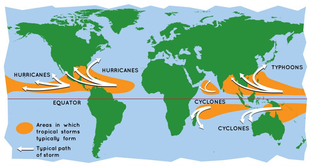
Names of Tropical Cyclones
Depending on its location and strength, a tropical cyclone is referred to by different names:
- Cyclones in the Indian Ocean
- Hurricanes in the Atlantic
- Typhoons in the Western Pacific and the South China Sea
- Willy-willies in Western Australia
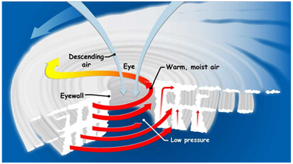
Structure of the tropical cyclone
Tropical cyclones are compact, circular storms, generally some 320 km (200 miles) in diameter, whose winds swirl around a central region of low atmospheric pressure. The winds are driven by this low-pressure core and by the rotation of Earth, which deflects the path of the wind through a phenomenon known as the Coriolis force. As a result, tropical cyclones rotate in a counter clockwise (or cyclonic) direction in the Northern Hemisphere and in a clockwise (or anticyclonic) direction in the Southern Hemisphere.
- The Eye: A characteristic feature of tropical cyclones is the eye, a central region of clear skies, warm temperatures, and low atmospheric pressure. Typically, atmospheric pressure at the surface of Earth is about 1,000 millibars.
- The Eyewall: The most dangerous and destructive part of a tropical cyclone is the eyewall. Here winds are strongest, rainfall is heaviest, and deep convective clouds rise from close to Earth’s surface to a height of 15,000 metres.
- Rainbands: These bands, commonly called rainbands, spiral into the centre of the storm. In some cases the rainbands are stationary relative to the centre of the moving storm, and in other cases they seem to rotate around the centre.
Landfall, what happens when a Cyclone reaches land from the ocean?
- Tropical cyclones dissipate when they can no longer extract sufficient energy from warm ocean water.
- A storm that moves over land will abruptly lose its fuel source and quickly lose intensity.
- A tropical cyclone can contribute to its own demise by stirring up deeper, cooler ocean waters. tropical cyclone can contribute to its own demise by stirring up deeper, cooler ocean waters.
Cyclone Management in India
India is highly vulnerable to natural disasters especially cyclones, earthquakes, floods, landslides, and drought. Natural disasters cause a loss of 2% of GDP every year in India. According to the Home ministry, 8% of total area in India is prone to cyclones. India has a coastline of 7,516 km, of which 5,700 km are prone to cyclones of various degrees.
- Loss due to cyclones: Loss of lives, livelihood opportunities, damage to public and private property and severe damage to infrastructure are the resultant consequences, which can disrupt the process of development
- Indian Meteorological Department (IMD) is the nodal agency for early warning of cyclones and floods.
- Natural Disaster Management Authority is mandated to deal with the disaster management in India. It has prepared National Guidelines on Management of Cyclone.
- National Cyclone Risk Mitigation Project (NCRMP) was launched by Home ministry to upgrade the forecasting, tracking and warning about cyclones in states.
- National Disaster Response Force (NDRF) has done a commendable performance in rescuing and managing relief work.
- National Disaster Response Reserve (NDRR)– a fund of 250 crores operated by NDRF for maintaining inventory for an emergency situation.
- In 2016, a blueprint of National Disaster Management Plan was unveiled to tackle disaster. It provides a framework to deal with prevention, mitigation, response and recovery during a disaster. According to the plan, Ministry of earth science will be responsible for disaster management of cyclone. By this plan, India joined the list of countries which follow the Sendai Framework for Disaster Risk Reduction 2015-2030.
- Due to increased awareness and tracking of Cyclone, the death toll has been reduced substantially. For example, Very severe cyclone Hudhud and Phailin claimed lives of around 138 and 45 people respectively, which might have been more. It was reduced due to the early warning and relocation of the population from the cyclone-hit areas. Very severe cyclone Ockhi claimed many lives of people in Tamil Nadu and Kerala. This was due to the unprecedented change in the direction of the cyclone.
- But the destruction of infrastructure due to cyclonic hit is not been reduced which leads to increase in poverty due to the economic weakening of the affected population.
-Source: Indian Express
CCI Imposes Penalty On Google
Context:
The Competition Commission of India (CCI) on Tuesday imposed a penalty of Rs. 936.44 crore on Google for “abusing its dominant position with respect to its Play Store policies”, in the second such penalty on the Internet giant within a week.
Relevance:
GS II- Polity and Governance (Government Interventions)
Dimensions of the Article:
- Key points
- About competition commission of India
Key Points:
- For app developers, app stores have become a necessary medium for distribution of their apps to the end users and the availability of app store(s) is directly dependent on OS installed on a smart device.
- Google’s Play Store constitutes the main distribution channel for app developers in the Android mobile ecosystem, which allows its owners to capitalize on the apps brought to market.
- Selling of in-app digital goods constitutes an important means for app developers to monetize their creations/innovations.
- Google’s Play Store policies require the App developers to exclusively and mandatorily use Google Play’s Billing System (GPBS) not only for receiving payments for Apps (and other digital products like audio, video, games) distributed/sold through the Google Play Store but also for certain in-app purchases.
- Further, app developers cannot, within an app, provide users with a direct link to a webpage containing an alternative payment method or use language that encourages a user to purchase the digital item outside of the app (anti-steering provisions).
- If the app developers do not comply with Google’s policy of using GPBS, they are not permitted to list their apps on the Play Store.
- Thus, they would lose out the vast pool of potential customers in the form of Android users.
- Making access to the Play Store dependent on mandatory usage of GPBS for paid apps and in-app purchases is one sided and arbitrary and devoid of any legitimate business interest.
- The app developers are left bereft of the inherent choice to use payment processor of their liking from the open market.
- The CCI has also examined the allegations of exclusion of rival UPI apps as effective payment options on Play Store.
- Google is found to be following discriminatory practices by not using GPBS for its own applications i.e., YouTube. This also amount to imposition of discriminatory conditions as well as pricing as YouTube is not paying the service fee as being imposed on other apps covered in the GPBS requirements.
- Mandatory imposition of GPBS disturbs innovation incentives and the ability of both the payment processors as well as app developers to undertake technical development and innovate and thus, tantamount to limiting technical development in the market for in-app payment processing services.
- Hence, Google was found to violate various provisions of the Competition Act, 2002.
About competition commission of India:
- Nodal: Ministry of corporate affairs
- Competition Commission of India (CCI) is a statutory body of the Government of India responsible for enforcing the Competition Act, 2002.
- Competition Commission of India aims to establish a robust competitive environment.
- Through proactive engagement with all stakeholders, including consumers, industry, government and international jurisdictions.
- By being a knowledge intensive organization with high competence level.
- Through professionalism, transparency, resolve and wisdom in enforcement.
Composition of CCI:
- The Commission consists of one Chairperson and six Members.
- The commission is a quasi-judicial body .
- Eligibility of members: The Chairperson and every other Member shall be a person of ability, integrity and standing and who, has been, or is qualified to be a judge of a High Court, or, has special knowledge of, and professional experience of not less than fifteen years in international trade, economics, business, commerce, law, finance, accountancy, management, industry, public affairs, administration or in any other matter which, in the opinion of the Central Government, may be useful to the Commission.
-Source: The Hindu, PIB


