Focus: GS-I Geography, Prelims
Why in news?
- Data from an oil and gas exploration company has now helped geologists discover a series of faults at the foot of the Himalaya.
- This fault system in the southeastern region of Nepal has the potential to cause earthquakes in the densely populated country.
How were the fault lines found?
- The team looked at seismic reflection data, which are routinely collected by exploration companies looking for oil and gas.
- In this method, seismic waves are produced by small explosions at multiple sources, and many recorders called geophones record the sound echoing off layers beneath the surface.
- The signals are combined to make an image that looks like a slice showing layers through the top few kilometres of the Earth’s crust.
Seismic waves: Can these new fault lines affect India?
- The faults were detected don’t appear to extend into India, but seismic waves from an earthquake occurring on them might affect regions of India near the border.
- Other similar faults might be present elsewhere along the southern edge of the Himalaya and might extend beneath northern India.
Click Here to read more about Earthquakes and Seismic Waves
Earthquake zones of India
- The major reason for the high frequency and intensity of the earthquakes is that the Indian plate is driving into Asia at a rate of approximately 47 mm/year.
- Geographical statistics of India show that more than 50% of the land is vulnerable to earthquakes.
- The latest version of seismic zoning map of India divides India into 4 seismic zones (Zone 2, 3, 4 and 5).
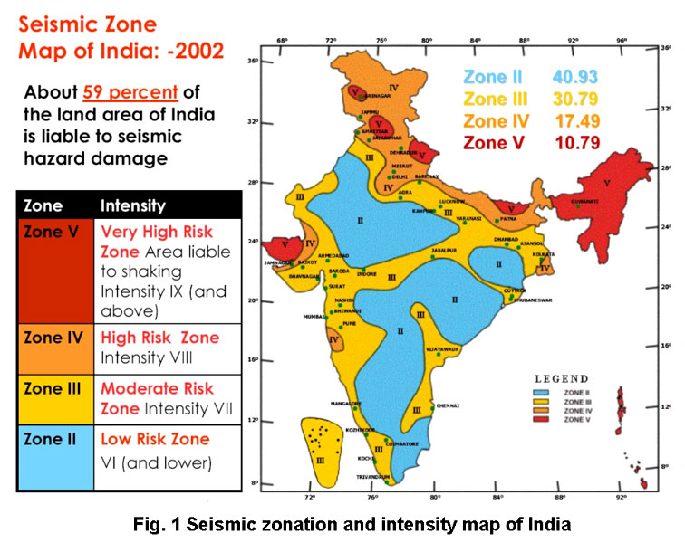
Zones of Seismicity
- Zone 1: Currently the Division does not include a Zone 1. NO area of India is classed as Zone 1.
- Zone 2: This region is liable to MSK VI or less and is classified as the Low Damage Risk Zone.
- Zone 3: This zone is classified as Moderate Damage Risk Zone which is liable to MSK VII.
- Zone 4: This zone is called the High Damage Risk Zone and covers areas liable to MSK VIII. Jammu and Kashmir, Ladakh, Himachal Pradesh, Uttarakhand, Sikkim, the parts of Indo-Gangetic plains (North Punjab, Chandigarh, Western Uttar Pradesh, Terai, North Bengal, Sundarbans) and the capital of the country Delhi fall in Zone 4.
- Zone 5: Zone 5 covers the areas with the highest risks zone that suffers earthquakes of intensity MSK IX or greater. The region of Kashmir, the Western and Central Himalayas, North and Middle Bihar, the North-East Indian region, the Rann of Kutch and the Andaman and Nicobar group of islands fall in this zone.
Measurement of earthquakes
The earthquake events are scaled either according to the magnitude or intensity of the shock.
- Richter scale – The magnitude scale is known as the Richter scale. The magnitude relates to the energy released during the quake. The magnitude is expressed in absolute numbers, 0-10.
- Mercalli scale – The intensity scale is named after Mercalli, an Italian seismologist. The intensity scale takes into account the visible damage caused by the event. The range of intensity scale is from 1-12.
- Medvedev–Sponheuer–Karnik scale – This is a macroseismic intensity scale used to evaluate the severity of ground shaking on the basis of observed effects in an area of the earthquake occurrence.
-Source: The Hindu


