Why in news?
- As per the forecast guidance from various numerical weather prediction models and the environmental and thermo-dynamical conditions prevailing over the region, a Low-Pressure Area is very likely to form over South Andaman Sea and neighbourhood around 30th April 2020.
- It is very likely to intensify further during subsequent 48 hours and very likely to move north-northwestwards initially and then north-northeastwards along & off Andaman & Nicobar Islands during 30th April – 3rd May 2020.
- The Cyclone Warning Division of the India Meteorological Department says that the system is under continuous surveillance and the concerned state governments are being informed regularly.
Adverse weather that might be caused around Andaman & Nicobar Islands
- Rainfall: Light to moderate rainfall at many places with heavy falls at isolated places is very likely over Nicobar Islands.
- Wind warning: Squally winds, speed reaching 40-50 kmph gusting to 60 kmph are likely to prevail.
- Sea condition: Sea conditions will be rough to very rough.
- Fishermen Warning: The fishermen are advised not to venture into the Sea along & off north Sumatra coast, Andaman Sea and adjoining areas of southeast & east central Bay of Bengal from 30th April to 3rd May 2020.
Andaman Sea:
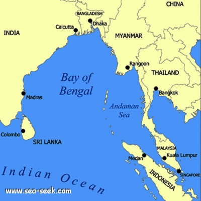
- The Andaman Sea is a marginal sea of northeastern Indian Ocean bounded by the coastlines of Myanmar and Thailand along the Gulf of Martaban and west side of the Malay Peninsula, and separated from the Bay of Bengal to its west by the Andaman Islands and the Nicobar Islands.
- Its southernmost end is defined by Breueh Island, an island just north of Sumatra, and communicates with the Malacca Strait.
Low-pressure area
- A low-pressure area, low area or low is a region on the topographic map where the air pressure is lower than that of surrounding locations.
- Low-pressure systems form under areas of wind divergence that occur in the upper levels of the atmosphere.
- The formation process of a low-pressure area is known as cyclogenesis.
- Within the field of meteorology, atmospheric divergence aloft occurs in two areas.
- The first area is on the east side of upper troughs, which form half of a Rossby wave within the Westerlies (a trough with large wavelength that extends through the troposphere).
- A second area of wind divergence aloft occurs ahead of embedded shortwave troughs, which are of smaller wavelength.
- Diverging winds aloft ahead of these troughs cause atmospheric lift within the troposphere below, which lowers surface pressures as upward motion partially counteracts the force of gravity.
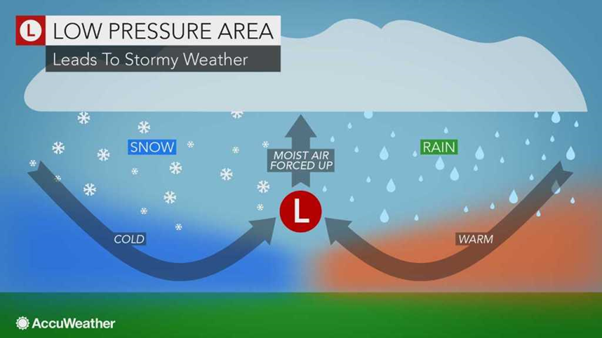
How are Low-Pressure Areas formed?
- Thermal lows form due to localized heating caused by greater sunshine over deserts and other land masses.
- Since localized areas of warm air are less dense than their surroundings, this warmer air rises, which lowers atmospheric pressure near that portion of the Earth’s surface.
- Large-scale thermal lows over continents help drive monsoon circulations.
- Low-pressure areas can also form due to organized thunderstorm activity over warm water.


