Mission Overview:
- Launch Date: July 31, 2025
- Agencies: Jointly developed by NASA (USA) and ISRO (India)
- Launch Vehicle & Site: Launched aboard GSLV-F16 from Sriharikota
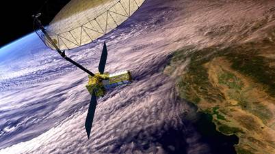
- Satellite Type: Earth Observation Satellite with dual-frequency SAR (Synthetic Aperture Radar) – a global first
Relevance : GS 3(Science and Technology)
Technological Breakthroughs:
- Dual-frequency SAR:
- Uses L-band (NASA) and S-band (ISRO) radars
- First satellite globally to integrate two radar frequencies on a single platform
- High-resolution imaging:
- Detects surface movements <1 cm over areas as small as half a tennis court
- Massive Reflector:
- 12-meter (≈40 feet) deployable reflector
- Would require a 5-mile solid antenna to match resolution without SAR
Core Capabilities:
- Surface Deformation Mapping:
- Detects subtle shifts in earth’s crust: useful for volcanoes, landslides, earthquakes
- Forest Monitoring:
- Tracks deforestation, biomass changes, and carbon stock
- Disaster Prediction & Response:
- Identifies land instability and wildfire risks (via dry fuel detection)
- Post-disaster Assessment:
- Monitors building shifts, infrastructure damage after earthquakes
- Agricultural Monitoring:
- Precision farming, crop monitoring, soil moisture mapping
Strategic and Scientific Relevance:
- Climate Change Mitigation:
- Monitors glacial retreat, sea-level rise, ground subsidence
- Planetary Science Linkages:
- Data can improve models of planetary interiors (e.g., Mars tectonics)
- Data for Global Earth System Models:
- Enhances simulation accuracy for hydrological, geological, and atmospheric changes
Calibration Challenges & Innovations:
- Cross-Band Calibration:
- L-band and S-band feeds are slightly offset; calibrated using corner reflectors
- Thermal Load Issues:
- Reflector had to be redesigned with heat-resistant coatings after thermal vacuum testing revealed overheating risks
- COVID-induced Delays:
- Remote collaboration, in-person testing disruption led to 11-year build time
Early Adopters Program:
- 200+ Early Adopters Globally:
- Farmers, insurers, geologists, infrastructure firms, and climate modelers are preparing to use NISAR data
- Use-Cases:
- Earthquake early warning systems
- Infrastructure stress mapping (railways, dams)
- Risk models for insurance and disaster finance
- Monitoring crop yield patterns for food security
Commercial & Industrial Demand:
- Widespread Commercial Utility:
- 75% of NASA’s Earth Observation users are from .com domains
- 75% of Fortune 100 companies already use EO data
- Sectors: Agriculture, Insurance, Finance, Transportation, Urban Planning
- Expected Applications from NISAR:
- Customized analytics for climate-resilient infrastructure
- Precision agriculture for yield optimization
- Urban risk zoning and planning
International Collaboration & Diplomacy:
- NASA-ISRO Partnership:
- A landmark in Indo-US space diplomacy
- NISAR becomes a symbol of South-North tech collaboration in climate resilience and disaster management
- Technology Transfer:
- Expertise from JPL’s planetary radar missions now powering earth observation systems
Cost & Engineering Complexity:
- Mission Duration: 11 years in making
- Engineering Feats:
- Coordination of dozens of subsystems, radar alignment precision
- Overcame pandemic disruptions, transcontinental assembly and testing
Future Prospects:
- Open-Access Data Policy:
- ISRO is expected to follow a similar free and open access model
- Capacity Building in South Asia:
- Potential for data-driven capacity building for disaster response in Nepal, Bangladesh, Sri Lanka
- Potential Legacy:
- Could catalyze a new generation of hybrid remote sensing satellites combining radar, optical, and hyperspectral instruments


