Historical Background: The Basis of the Border
- Manchu Rule (1644–1911):
- Two major maps drawn with European Jesuit assistance:
- Kang-hsi Map (1721): Tibet-Assam segment; Tibet considered only up to the Himalayas; Tawang (south of Himalayas) not Tibetan.
- Ch’ien-lung Map (1761): Eastern Turkestan-Kashmir segment; Eastern Turkestan not conceived as trans-Kunlun; southern desolate region not claimed.
- Two major maps drawn with European Jesuit assistance:
- 1913–14 Simla Conference:
- RoC delegate accepted non-Tibetan tribal belt (present Arunachal Pradesh) was not Tibetan.
- India included it in Assam; outcome consistent with Kang-hsi’s map.
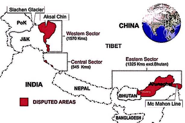
- Implication: Traditional Chinese claims were limited; historical maps did not support trans-Himalayan claims in Arunachal Pradesh or Aksai Chin.
Relevance:
- GS II (International Relations & Security): India-China boundary disputes, historical treaties, diplomatic negotiations.
- GS I (Geography & History): Geopolitical importance of Arunachal Pradesh and Aksai Chin, historical mapping.
- GS III (Security): Strategic implications of border management, principle-based negotiation, territorial sovereignty.
Evolution of Chinese Claims
- 1943: RoC sets aside Manchu maps; claims large Indian territories during WWII.
- Justification: map described as “unprecise draft.”
- December 1947: Similar map used amid India-Pakistan conflict.
- Pattern: China inherited and expanded claim-making from predecessor regimes rather than based on historical precedent.
Post-Independence Diplomacy
- 1960 Talks (Jawaharlal Nehru & Chou En-lai):
- Chou questioned India’s historical evidence, using semantic and rhetorical tactics.
- Proposed resolving the boundary not solely on maps, but via principles: equitable, reasonable, dignity-preserving “package deal.”
- Key Insight (Vijay Gokhale, The Long Game):
- Chou avoided suggesting territorial swap (Aksai Chin ↔ Arunachal Pradesh).
- Both sides aimed for comprehensive resolution, integrating boundary, geopolitical, and trade matters.
Specific Boundary Alignments
- 1914 Alignment: Indo-Tibetan boundary in line with Kang-hsi map; acknowledged by both parties at the time.
- 1899 Alignment: Kashmir-Sinkiang boundary line; based on watershed principle; related to Aksai Chin.
Core Principles for Resolution
- Equity & Respect: No defeat to either side; preserve dignity and self-respect.
- Historical Evidence: Manchu-era maps provide strongest evidence for India’s claims.
- Geopolitical Package Approach: Consider boundary settlement along with trade and security issues; possibility of territorial swap remains contingent on mutual security needs.
Key Takeaways
- Historical maps favor India: Manchu-era records clearly delineate Tibet’s southern boundary and Aksai Chin claims.
- China’s modern claims: Largely political opportunism during moments of Indian vulnerability; not supported by historical documentation.
- Diplomatic complexity: Both sides acknowledge need for principles beyond maps to achieve a sustainable, dignified settlement.
- Strategic perspective: India must maintain historical evidence, assert sovereignty, and engage in principle-based negotiations while safeguarding national security.