Context:
October to December period is among the favourable months for the development of cyclones in the Bay of Bengal and the Arabian Sea. This year, however, October passed without witnessing a cyclonic storm.
Relevance:
GS Paper 1: Salient Features of World Physical Geography; Important Geophysical phenomena (earthquakes, tsunami, volcanoes, cyclones); Geographical features and location;
GS Paper 3: Disasters & Disaster Management
Mains questions
- Tropical cyclones are largely confined to South China Sea, Bay of Bengal and Gulf of Mexico. Why? 15 marks
- India’s east and west coasts are prone to cyclones with the maximum associated hazards—rain, heavy winds and storm surge— faced by coastal districts of West Bengal, Odisha and Andhra Pradesh. Elaborate. 15 marks
Dimensions of the article
- What is tropical cyclone?
- Favourable conditions for tropical cyclone.
- Structure of the tropical cyclone.
- Cyclone risk in India
- Cyclone hazards mitigation
What is tropical cyclone?
Tropical cyclone, also called typhoon or hurricane, an intense circular storm that originates over warm tropical oceans and is characterized by low atmospheric pressure, high winds, and heavy rain. Drawing energy from the sea surface and maintaining its strength as long as it remains over warm water, a tropical cyclone generates winds that exceed 119 km (74 miles) per hour.
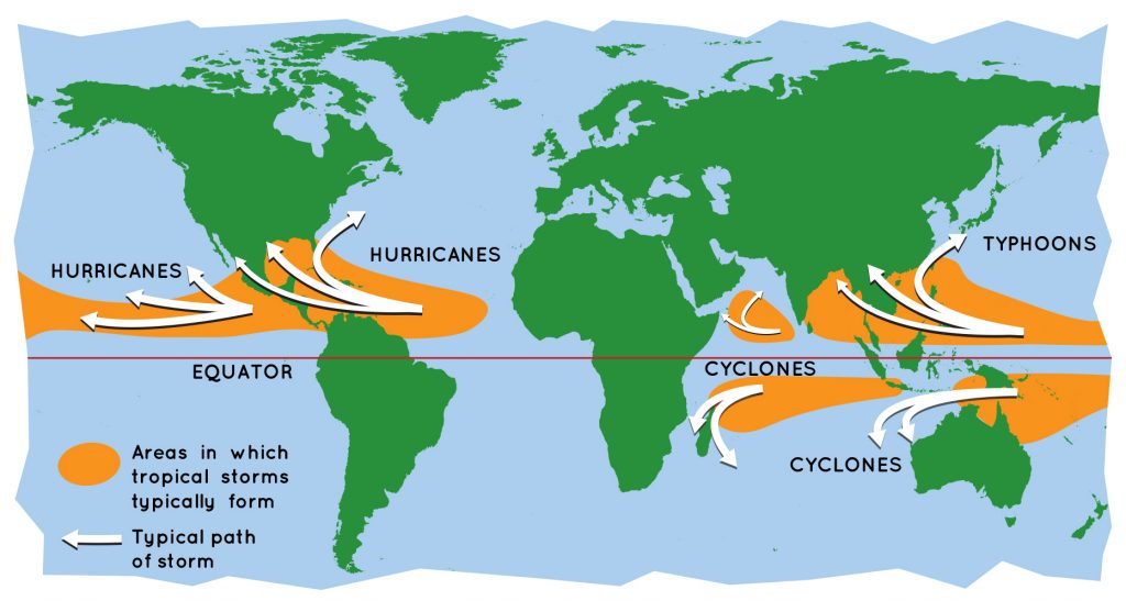
Every year during the late summer months (July–September in the Northern Hemisphere and January–March in the Southern Hemisphere), cyclones strike regions as far apart as the Gulf Coast of North America, north-western Australia, and eastern India and Bangladesh. Tropical cyclones are known by various names in different parts of the world.
- In the North Atlantic Ocean and the eastern North Pacific they are called hurricanes.
- In the western North Pacific around the Philippines, Japan, and China the storms are referred to as typhoons.
- In the western South Pacific and Indian Ocean they are variously referred to as severe tropical cyclones, tropical cyclones, or simply cyclones.
Favourable conditions for tropical cyclone:
There are six conditions favourable for this process to take place.
- The temperature of the surface layer of ocean water must be 26.5 °C (80 °F) or warmer, and this warm layer must be at least 50 metres (150 feet) deep.
- A pre-existing atmospheric circulation must be located near the surface warm layer.
- The atmosphere must cool quickly enough with height to support the formation of deep convective clouds.
- The middle atmosphere must be relatively humid at a height of about 5,000 metres (16,000 feet) above the surface.
- The developing system must be at least 500 km (300 miles) away from the Equator.
- The wind speed must change slowly with height through the troposphere—no more than 10 metres (33 feet) per second between the surface and an altitude of about 10,000 metres.
Energy of tropical cyclone
The energy that intensifies the storm, comes from the condensation process in the towering cumulonimbus clouds, surrounding the centre of the storm. With continuous supply of moisture from the sea, the storm is further strengthened. On reaching the land the moisture supply is cut off and the storm dissipates.
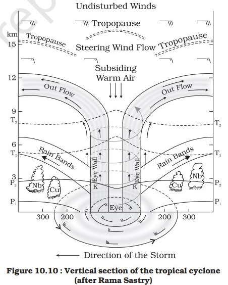
Structure of the tropical cyclone
Tropical cyclones are compact, circular storms, generally some 320 km (200 miles) in diameter, whose winds swirl around a central region of low atmospheric pressure. The winds are driven by this low-pressure core and by the rotation of Earth, which deflects the path of the wind through a phenomenon known as the Coriolis force. As a result, tropical cyclones rotate in a counter clockwise (or cyclonic) direction in the Northern Hemisphere and in a clockwise (or anticyclonic) direction in the Southern Hemisphere.
- The Eye: A characteristic feature of tropical cyclones is the eye, a central region of clear skies, warm temperatures, and low atmospheric pressure. Typically, atmospheric pressure at the surface of Earth is about 1,000 millibars.
- The Eyewall: The most dangerous and destructive part of a tropical cyclone is the eyewall. Here winds are strongest, rainfall is heaviest, and deep convective clouds rise from close to Earth’s surface to a height of 15,000 metres.
- Rainbands: These bands, commonly called rainbands, spiral into the centre of the storm. In some cases the rainbands are stationary relative to the centre of the moving storm, and in other cases they seem to rotate around the centre.
Cyclone risk in India
India has a coastline of about 7,516 km, 5,400 km along the mainland, 132 km in Lakshadweep and 1,900 km in the Andaman and Nicobar Islands. Although the North Indian Ocean (NIO) Basin (including the Indian coast) generates only about 7% of the world’s cyclones, their impact is comparatively high and devastating, especially when they strike the coasts bordering the North Bay of Bengal. On an average, five to six tropical cyclones form every year, of which two or three could be severe.
When do cyclones form and hit Indian coasts?
About 80 cyclones are formed around the world annually, out of which five are formed in the Bay of Bengal and the Arabian Sea, together known as the North Indian Ocean. India’s east and west coasts are prone to cyclones with the maximum associated hazards—rain, heavy winds and storm surge— faced by coastal districts of West Bengal, Odisha and Andhra Pradesh. Cyclones in the North Indian Ocean are bi-modal in nature, that is, they occur during two seasons— April to June (pre-monsoon) and October to December (post-monsoon). Of these, May and November remain the most conducive for the development of cyclones.
Why were there no cyclone developments this year?
IMD officials have attributed it to the weak La Nina conditions along the equatorial Pacific Ocean. Cooler than normal sea surface temperatures over this region—termed as La Nina— has been prevailing since August this year. Because Madden Julian Oscillation (MJO) was positioned in a favourable phase, the low-pressure systems intensified maximum up to a deep depression. MJO is kind of an eastward-moving cyclic weather event along the tropics that influences rainfall, winds, sea surface temperatures and cloud cover.
Cyclone hazards mitigation
- Coastal belt plantation – Providing a cover through green belt sustains less damage as forests act as a wide buffer zone against strong winds and flash floods. Without the forest the cyclone travel freely inland.
- Hazard mapping – Meteorological records of the wind speed and the directions give the pattern of occurrence of cyclone for particular wind speeds. A hazard map will illustrate the areas vulnerable to cyclone in any given year and estimate the severity of the cyclone and various damage intensities in the region.
- Land use control- can be designed so that least critical activities are placed in vulnerable areas. Location of settlements in the flood plains is at utmost risk. Citing of key facilities must be marked in the land use. Policies should be in place to regulate land use and building codes should be enforced.
- Engineered structures – need to be built to withstand wind forces. Good site selection is also important. Majority of the buildings in coastal areas are built with locally available materials and have no engineering inputs.
- Flood management – Torrential rains, strong wind and storm range leads to flooding in the cyclone affected areas. There are possibilities of landslides too. Flood mitigation measures can be incorporated.
- Improving vegetation cover – The roots of the plants and trees keep the soil intact and prevent erosion and slow runoff to prevent or lessen flooding. The use of tree planted in rows will act as a windbreak.
- Coastal shelterbelt plantations can be developed to break severe wind speeds. It minimizes devastating effects.
Background:
National Cyclone Risk Mitigation Project (NCRMP)
The project aims at minimizing the vulnerability to the cyclone and making people and infrastructure disaster resilient. The project has four principal components namely:
- Component A- Last Mile Connectivity.
- Component B– Structural and Non-Structural Measures.
- Component C- Technical Assistance for Cyclone Hazard Risk Mitigation, Capacity Building and Knowledge Creation.
- Component D– Project Management and Implementation Support.


