Context:
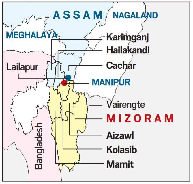
Recently, several IED (Improvised Explosive Device) blasts were carried out inside Cachar district of Assam allegedly by miscreants from Mizoram.
Relevance:
GS-II: Polity and Governance (Inter-State Relations)
Dimensions of the Article:
- Background to the Assam – Mizoram Border Dispute
- Other Boundary Issues in Northeast
- Way Forward
Background to the Assam – Mizoram Border Dispute
- Mizoram borders Assam’s Barak Valley and the boundary between present-day Assam and Mizoram is 165 km long. Both states border Bangladesh.
- The boundary issue between present-day Assam and Mizoram dates back to the colonial era when inner lines were demarcated according to the administrative needs of British Raj.
- Assam became a constituent state of India in 1950 and lost much of its territory to new states that emerged from within its borders between the early 1960s and the early 1970s.
- Mizoram was granted statehood in 1987 by the State of Mizoram Act, 1986.
- The Assam-Mizoram dispute stems from a notification of 1875 that differentiated Lushai Hills (During colonial times, Mizoram was known as Lushai Hills) from the plains of Cachar, and another of 1933 that demarcates a boundary between Lushai Hills and Manipur.
- Mizoram believes the boundary should be demarcated on the basis of the 1875 notification, which is derived from the Bengal Eastern Frontier Regulation (BEFR) Act, 1873.
- According to an agreement between the governments of Assam and Mizoram, the status quo should be maintained in no man’s land in the border area.
- In the Northeast’s complex boundary equations, clashes between Assam and Mizoram residents are less frequent than they are between other neighbouring states of Assam, like with Nagaland.
Other Boundary Issues in Northeast
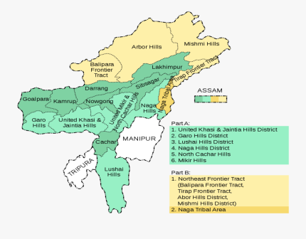
During British rule, Assam included present-day Nagaland, Arunachal Pradesh and Meghalaya besides Mizoram, which became separate states one by one.
- Assam-Nagaland: Nagaland shares a 500-km boundary with Assam and achieved statehood in December 1963 and was formed out of the Naga Hills district of Assam and Arunachal Pradesh (then North-East Frontier Agency). Violent clashes and armed conflicts, marked by killings, have occurred on the Assam-Nagaland border since 1965.
- Assam-Arunachal Pradesh: Arunachal Pradesh shares a 800-km boundary with Assam and was granted statehood by the State of Arunachal Pradesh Act, 1986 in 1987. Clashes were first reported in 1992 and since then, there have been several accusations of illegal encroachment from both sides, and intermittent clashes.
- Assam-Meghalaya: Meghalaya shares a 884-km boundary with Assam and came into existence as an autonomous state within the state of Assam in April 1970 comprising the United Khasi and Jaintia Hills and the Garo Hills districts. In 1972, it got statehood. As per Meghalaya government statements, today there are 12 areas of dispute between the two states.
Way Forward
- Boundary disputes between the states can be settled by using satellite mapping of the actual border locations.
- Reviving the Inter-state council (Article 263) can be an option for resolution of an Inter-state dispute.
- Zonal Councils could also be revived to discuss the matters of common concern to states in each zone—matters relating to social and economic planning, border disputes, inter-state transport, etc.
-Source: Financial Express


