Context:
With concerns mounting over the impact of climate change on Himalayan glaciers, the Ministry of Jal Shakti has released an updated atlas of glacial lakes that are part of the Ganga river basin.
Relevance:
GS-I: Geography (Physical Geography, Distribution of Key Natural Resources, Water Resources, Important Geophysical Phenomena)
Dimensions of the Article:
- What is a Glacier?
- What are Glacial lakes?
- About the new Atlas of glacial lakes in Ganga basin
- Important Glaciers in India
- What is GLOF?
- How can the risk of GLOFs be reduced?
What is a Glacier?
- A glacier is a persistent body of dense ice that is constantly moving under its own weight. It is form by the accumulation of snow exceeds its ablation (melting and sublimation) over many years. It is the largest reservoir of fresh water on the Earth (75 percent of the world’s fresh water).
- Glaciers are unique because they are reservoir of fresh water, have sheer mass and their ability to move (Glaciers flow like very slow rivers). It may move in two ways- Internal flow is when the pressure and gravity on the ice in a glacier cause it to move downhill; Basal sliding is when an entire glacier moves because its base is slightly melted. Rivers, valleys and lakes are formed after melting of glaciers.
- As per National Snow & Ice Date Centre, it occupies about 10 percent of the world’s total area.
What are Glacial lakes?
- A glacial lake is a body of water with origins from glacier activity.
- They are formed when a glacier erodes the land, and then melts, filling the depression created by the glacier.
How are glaciers and glacial lakes formed?
- Glaciers are found on every continent except Australia and some are hundreds of thousands of years old; and a large cluster of glaciers are in the Himalayas.
- Glaciers are made of layers of compressed snow that move or “flow” due to gravity and the softness of ice relative to rock.
- A glacier’s “tongue” can extend hundreds of kilometers from its high-altitude origins, and the end, or “snout,” can advance or retreat based on snow accumulating or melting.
- Proglacial lakes, formed after glaciers retreat, are often bound by sediment and boulder formations.
- Additional water or pressure, or structural weakness, can cause both natural and manmade dams to burst, sending a mass of floodwater surging down the rivers and streams fed by the glacier.
About the new Atlas of glacial lakes in Ganga basin
- About 4,707 glacial lakes have been mapped in the Ganga basin.
- Recently, a similar inventory of glacial lakes was prepared for the Indus River basin.
- Based on its process of lake formation, location, and type of damming material, glacial lakes are identified in nine different types, majorly grouped into four categories.
- The area mapped spans from the origin of the river to foothills of Himalayas covering a catchment area of almost 2.5 lakh sq. Km. The study portion of Ganga River basin covers part of India and transboundary region.
Uses of the Atlas of Glaciers and Glacial Lakes
- The expected “utility” of the atlas, according to a statement from the Ministry was to create a “comprehensive and systematic” glacial lake database for Ganga River basin.
- The atlas could be used as reference for carrying out changes in the lakes over time, the spatial extent (expansion/shrinkage), and formation of new lakes.
- The information on glacial lakes including their type, hydrological, topographical, and associated glaciers are useful in identifying the potential critical glacial lakes and consequent GLOF (Glacial Lake Outburst Flood) events. These refer to disasters whereby a deluge of water from such a lake can trigger a disaster.
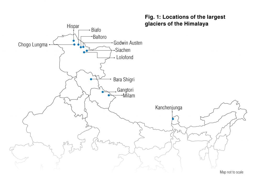
Important Glaciers in India
| Name | State | Mountain Range |
| Batura Glacier | Jammu & Kashmir | Karakoram Mountain Range |
| Khurdopin Glacier | Jammu & Kashmir | Karakoram Mountain Range |
| Hispar Glacier | Jammu & Kashmir | Karakoram Mountain Range |
| Biafo Glacier | Jammu & Kashmir | Karakoram Mountain Range |
| Baltoro Glacier | Jammu & Kashmir | Karakoram Mountain Range |
| Chomolungma glacier | Jammu & Kashmir | Karakoram Mountain Range |
| Diamir Glacier | Jammu & Kashmir | Karakoram Mountain Range |
| Siachen Glacier | Jammu & Kashmir | Karakoram Mountain Range |
| Gangotri Glacier | Uttarkashi, Uttarakhand | Himalayas |
| Milam Glacier | Uttarakhand | Trishul peak of Pithoragarh |
| Pindari glacier | Nanda Devi, Uttarakhand | Upper reaches of the Kumaon Himalayas |
| Zemu Glacier | Sikkim | Eastern Himalaya Located on Kanchenjunga peak |
What is GLOF?
- A GLOF is a type of outburst flood that occurs when the dam containing a glacial lake fails.
- An event similar to a GLOF, where a body of water contained by a glacier melts or overflows the glacier, is called a jökulhlaup.
- The dam can consist of glacier ice or a terminal moraine.
Causes of GLOF
- A buildup of water pressure or structural weakness of boundary due to an increase in the flow of water.
- An earthquake (Tectonic) or cryoseism (non-tectonic seismic event of the glacial cryosphere) can also cause GLOF. During this, the boundary of the glacial lake will collapse suddenly and release the water in the glacial lake.
- An avalanche of rock or heavy snow: During this, the water in the glacial lake might be displaced by the avalanche.
- Volcanic eruptions under the ice can also cause GLOF. These volcanic eruptions might displace the boundary or increase the pressure on glacial lake or both.
- Heavy rainfall/melting of snow: This can lead to massive displacement of water in a glacial lake.
- Long-term dam degradation can also induce GLOF.
- Other reasons such as the collapse of an adjacent glacial lake, etc.
How can the risk of GLOFs be reduced?
- The NDMA guidelines say that risk reduction has to begin with identifying and mapping such lakes, taking structural measures to prevent their sudden breach, and establishing mechanism to save lives and property in times of a breach.
- Potentially dangerous lakes can be identified based on field observations, records of past events, geomorphologic and geotechnical characteristics of the lake/dam and surroundings, and other physical conditions.
- NDMA has recommended use of Synthetic-Aperture Radar imagery to automatically detect changes in water bodies, including new lake formations, during the monsoon months. It has said methods and protocols could also be developed to allow remote monitoring of lake bodies from space.
- To manage lakes structurally, the NDMA recommends reducing the volume of water with methods such as controlled breaching, pumping or siphoning out water, and making a tunnel through the moraine barrier or under an ice dam.
-Source: The Hindu


