- Air expands when heated and gets compressed when cooled. This results in variations in the atmospheric pressure. The result is that it causes the movement of air from high pressure to low pressure
- The wind redistributes the heat and moisture across the planet, thereby, maintaining a constant temperature for the planet as a whole
Atmospheric pressure
The weight of a column of air contained in a unit area from the mean sea level to the top of the atmosphere is called the atmospheric pressure.
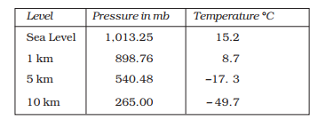
The atmospheric pressure is expressed in units of milibar. At sea level the average atmospheric pressure is 1,013.2 milibar. Due to gravity the air at the surface is denser and hence has higher pressure.
Vertical Variation of Pressure
In the lower atmosphere the pressure decreases rapidly with height. The decrease amounts to about 1 mb for each 10 m increase in elevation.
The vertical pressure gradient force is much larger than that of the horizontal pressure gradient. But, it is generally balanced by a nearly equal but opposite gravitational force. Hence, we do not experience strong upward winds
Horizontal distribution of pressure is studied by drawing isobars at constant levels. Isobars are lines connecting places having equal pressure
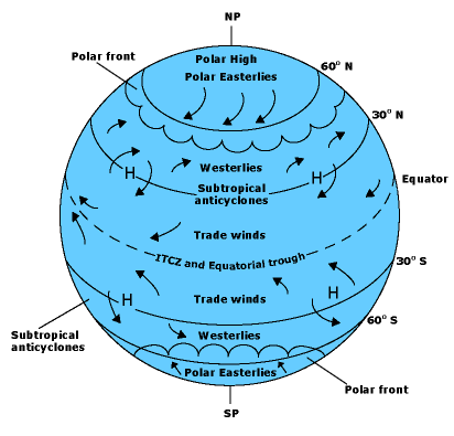
Near the equator the sea level pressure is low and the area is known as equatorial low. Along 30° N and 30o S are found the high-pressure areas known as the subtropical highs.
Further pole wards along 60 degree North and 60 degree South, the low-pressure belts are termed as the sub polar lows. Near the poles the pressure is high and it is known as the polar high.
Forces acting on winds
The force exerted by the rotation of the earth is known as the Coriolis force. Thus, the horizontal winds near the earth surface respond to the combined effect of three forces
The pressure gradient force
The differences in atmospheric pressure produces a force. The rate of change of pressure with respect to distance is the pressure gradient.
The frictional force
It affects the speed of the wind. It is greatest at the surface and its influence generally extends up to an elevation of 1 – 3 km.
The Coriolis force.
The rotation of the earth about its axis affects the direction of the wind. This force is called the Coriolis force.
- The Coriolis force is directly proportional to the angle of latitude. It is maximum at the poles and is absent at the equator
Pressure and wind
- The velocity and direction of the wind are the net result of the wind generating forces.
- The winds in the upper atmosphere, 2 – 3 km above the surface, are free from frictional effect of the surface and are controlled mainly by the pressure gradient and the Coriolis force.
- When isobars are straight and when there is no friction, the pressure gradient force is balanced by the Coriolis force and the resultant wind blows parallel to the isobar.
- This wind is known as the geostrophic wind
Cyclonic and Anti cyclonic circulation
- The wind circulation around a low is called cyclonic circulation.
- Around a high it is called anti cyclonic circulation.
- The direction of winds around such systems changes according to their location in different hemispheres
General circulation of the atmosphere The pattern of planetary winds largely depends on :
- latitudinal variation of atmosphere
- Emergence of pressure belt
- The migration of belts following apparent path of the sun
- The distribution of continents and oceans
- The rotation of earth.
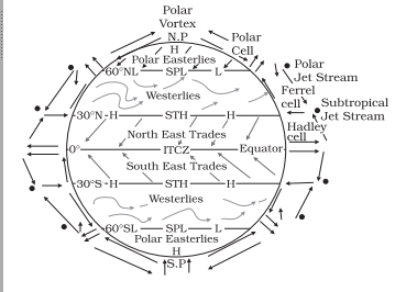
- The easterlies from either side of the equator converge in the Inter Tropical Convergence Zone (ITCZ).
- Such circulations from the surface upwards and vice-versa are called cells. Such a cell in the tropics is called Hadley Cell.
- In the middle latitudes the circulation is that of sinking cold air that comes from the poles and the rising warm air that blows from the subtropical high. At the surface these winds are called westerlies and the cell is known as the Ferrel cell
- At polar latitudes the cold dense air subsides near the poles and blows towards middle latitudes as the polar easterlies. This cell is called the polar cell.
Seasonal Wind
- The pattern of wind circulation is modified in different seasons due to the shifting of regions of maximum heating, pressure and wind belts.
- The most pronounced effect of such a shift is noticed in the monsoons, especially over southeast Asia.
Local Winds
Differences in the heating and cooling of earth surfaces and the cycles those develop daily or annually can create several common, local or regional winds.
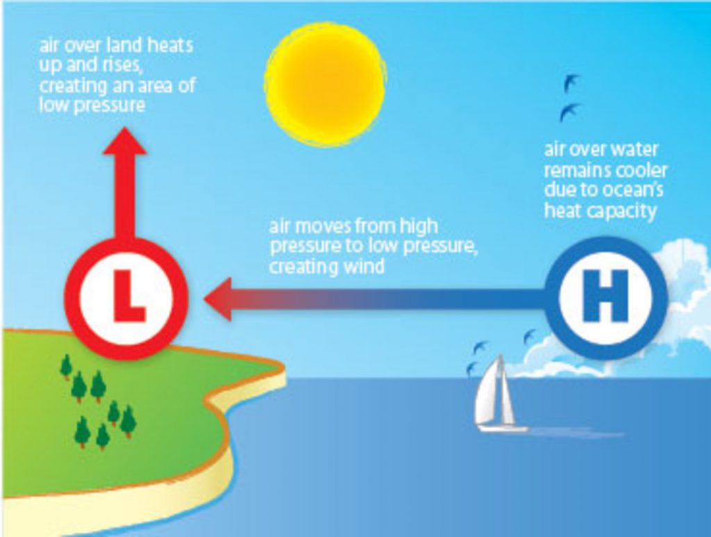
Land and Sea Breezes
During the day the land heats up faster and becomes warmer than the sea. Therefore, over the land the air rises giving rise to a low pressure area, whereas the sea is relatively cool and the pressure over sea is relatively high. Thus, pressure gradient from sea to land is created and the wind blows from the sea to the land as the sea breeze
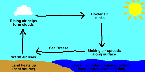
In the night the reversal of condition takes place. The land loses heat faster and is cooler than the sea. The pressure gradient is from the land to the sea
Mountain and Valley Winds
- In mountainous regions, during the day the slopes get heated up and air moves upslope and to fill the resulting gap the air from the valley blows up the valley. This wind is known valley breeze
- During the night the slopes get cooled and the dense air descends into the valley as the mountain wind. The cool air, of the high plateaus and ice fields draining into the valley is called katabatic wind
Air Masses
When the air remains over a homogenous area for a sufficiently longer time, it acquires the characteristics of the area. The homogenous regions can be the vast ocean surface or vast plains.
The air with distinctive characteristics in terms of temperature and humidity is called an airmass
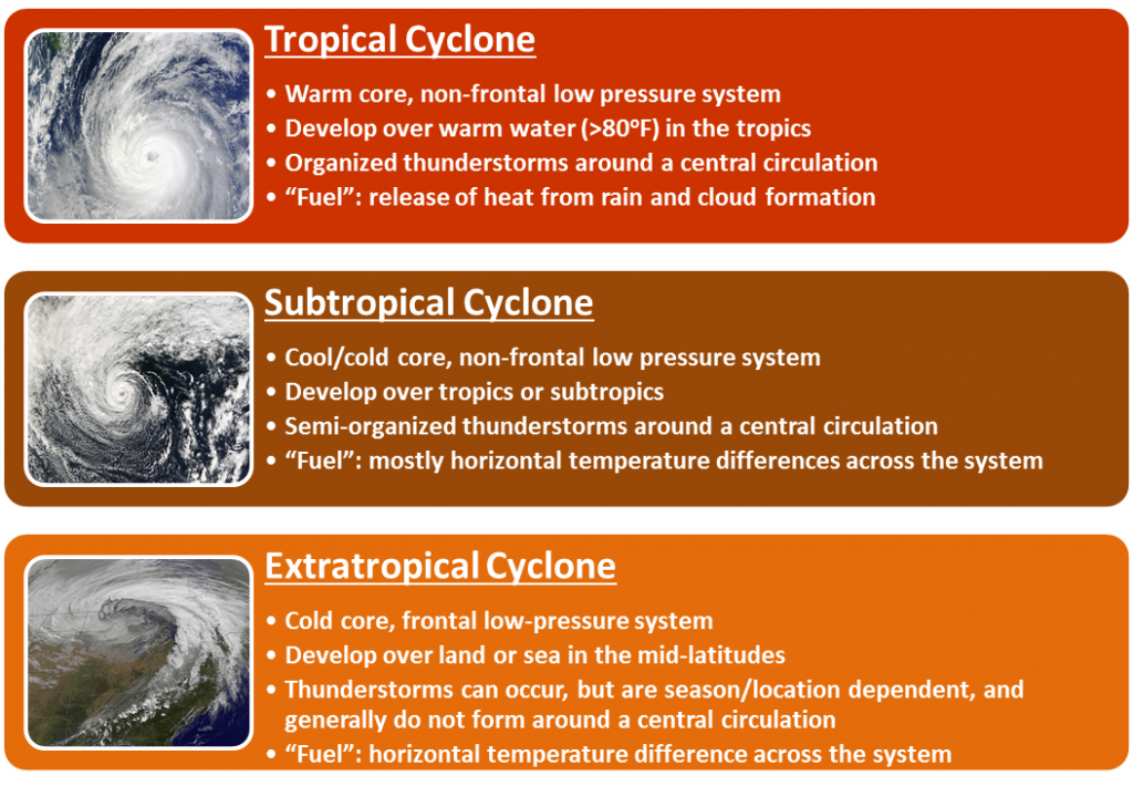
Extra Tropical Cyclones
- The systems developing in the mid and high latitude, beyond the tropics are called the middle latitude or extra tropical cyclones
- The warm air glides over the cold air and a sequence of clouds appear over the sky ahead of the warm front and cause precipitation.
- The cold front approaches the warm air from behind and pushes the warm air up. As a result, cumulus clouds develop along the cold front. The cold front moves faster than the warm front ultimately overtaking the warm front.
- The warm air is completely lifted up and the front is occluded and the cyclone dissipates.
TROPICAL CYCLONE
Tropical cyclones are violent storms that originate over oceans in tropical areas and move over to the coastal areas bringing about large scale destruction caused by violent winds, very heavy rainfall and storm surges.
This is one of the most devastating natural calamities. They are known as Cyclones in the Indian Ocean, Hurricanes in the Atlantic, Typhoons in the Western Pacific and South China Sea, and Willy-willies in the Western Australia
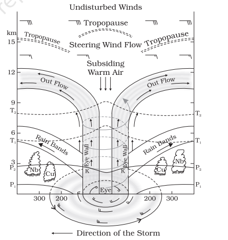
- The energy that intensifies the storm, comes from the condensation process in the towering cumulonimbus clouds, surrounding the centre of the storm. With continuous supply of moisture from the sea, the storm is further strengthened.
- On reaching the land the moisture supply is cut off and the storm dissipates
- The eye is a region of calm with subsiding air. Around the eye is the eye wall, where there is a strong spiralling ascent of air to greater height reaching the tropopause. The wind reaches maximum velocity in this region, reaching as high as 250 km per hour.
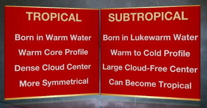
DIFFERENCE BETWEEN TROPICAL AND SUBTROPICAL CYCLONE