Contents:
- India’s retail inflation Surge
- China claims on Arunachal Pradesh
- La Ninã conditions enter 3rd year, 6th time since 1950
India’s retail inflation Surge
Context:
India’s retail Inflation has been a cause of concern for the economy since it surged past 6% in January
Relevance:
GS-III: Indian Economy (Growth and Development of Indian Economy, Fiscal Policy, Taxation)
Dimensions of the Article:
- About the Latest inflation data
- What is Inflation?
- What is Consumer Price Index (CPI)?
- Headline Inflation and Core Inflation
About the Latest inflation data:
- The surge in India’s retail inflation in the past few months is however not uniform throughout the country.
- There are wide disparities in the pace of price rise experienced by consumers across the country, with a dozen States clocking an average inflation of less than 6% and another 12 States averaging over 7% through 2022 so far.
- While headline inflation measured by the Consumer Price Index has averaged 6.8% in the first seven months of 2022, well above the 6% upper tolerance threshold set by policy makers.
- Retail prices in States like Kerala (4.8%), Tamil Nadu (5.01%), Punjab (5.35%), Delhi (5.56%), and Karnataka (5.84%) have been rising at less than 6%.
- Smaller States like Manipur, Goa and Meghalaya have had an average inflation of less than 4% through this period, at 1.07%, 3.66%, and 3.84%, respectively.
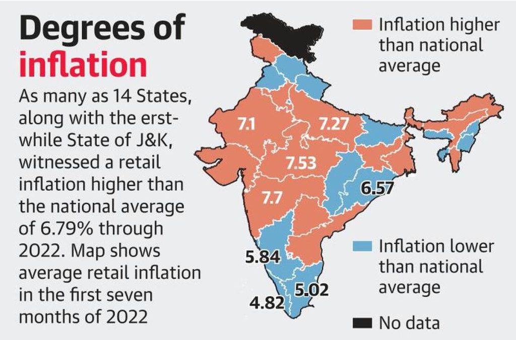
- As many as 14 States, along with the erstwhile State of Jammu & Kashmir, have witnessed price rise higher than the national average through 2022, with all but two of these States seeing higher than 7% inflation.
- Consumers in Telangana, West Bengal and Sikkim faced the steepest spike in prices, with their combined retail inflation for rural and urban areas averaging 8.32%, 8.06%, and 8.01%, respectively.
- The highest inflation during a month so far this year was recorded in Telangana, at 10.05% in June, but that has since subsided to a four-month low of 8.6% in July.
What is Consumer Price Index (CPI)?
- Consumer Price Index (CPI) measures price changes from the perspective of a retail buyer.
- CPI is released by the National Statistical Office (NSO).
- Base Year for CPI is 2012 and the Monetary Policy Committee (MPC) uses CPI data to control inflation.
- The CPI calculates the difference in the price of commodities and services such as food, medical care, education, electronics etc, which Indian consumers buy for use.
- The CPI has several sub-groups including food and beverages, fuel and light, housing and clothing, bedding and footwear.
- Four types of CPI are as follows:
- CPI for Industrial Workers (IW).
- CPI for Agricultural Labourer (AL).
- CPI for Rural Labourer (RL).
- CPI (Rural/Urban/Combined).
- Of these, CPI for Industrial Workers (IW), CPI for Agricultural Labourer (AL) and CPI for Rural Labourer (RL) are compiled by the Labour Bureau in the Ministry of Labour and Employment.
- CPI (Rural/Urban/Combined) is compiled by the National Statistical Office (NSO) in the Ministry of Statistics and Programme Implementation.
Headline Inflation and Core Inflation
- Headline inflation: Headline Inflation refers to the overall change in price level and is susceptible to supply shocks.
- Core inflation: Core inflation gives the underlying trend of inflation by exempting goods and services whose prices are highly volatile.
- Core inflation = Headline inflation – (Food and Fuel) inflation.
-Source: The Hindu
China claims on Arunachal Pradesh
Context:
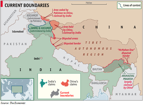
China’s claims on Arunachal Pradesh are “outrageous” and its transgressions at the Line of Actual Control (LAC) with India are a “violation of the international order”, said Germany’s new Ambassador to India, drawing parallels between Russia’s invasion of Ukraine and China’s “infringement” on India’s border.
Relevance:
GS-II: International Relations (India’s Neighbors, Foreign Policies affecting India’s Interests)
Dimensions of the Article:
- Chinese claim over Arunachal Pradesh
- India and Arunachal Pradesh
- Why Arunachal Pradesh? What is China’s Interest In Arunachal Pradesh?
- The McMahon Line
Chinese claim over Arunachal Pradesh
- When the new Peoples Republic of China was formed in February 1912 after the abdication of the Qing emperor, the Tibetans asserted their independence.
- They forced the Chinese troops based in Lhasa to return to the mainland-via India. A year later, Tibet declared independence from China.
- In order to ensure that the unrest did not spread to India and assert their boundaries, the ruling British convened a tripartite meeting at Shimla with Tibetan and Chinese delegates to define the border.
- The meeting gave China suzerainty over most of Tibet, and the boundary defined in this treaty was later known as the McMohan line.
- The Chinese Foreign Ministry said that China’s “position on Zangnan or South Tibet, as China refers to Arunachal] region is consistent and clear. We never recognised the so-called Arunachal Pradesh.”
India and Arunachal Pradesh
- Arunachal Pradesh (called South Tibet in China) is a full-fledged state of India.
- India’s sovereignty over the area is internationally recognized and its residents have not shown any inclination to leave India.
- The majority of the international maps acknowledge the area to be an Indian Territory.
- China has some (pre-) historical claims through its ownership of Tibet, but the people and geography primarily favor India.
Why Arunachal Pradesh? What is China’s Interest In Arunachal Pradesh?
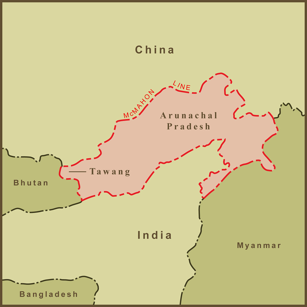
- Arunachal Pradesh known as the North East Frontier Agency (NEFA) until 1972, is the largest state in the northeast and shares international borders with to the north and northwest, Bhutan towards the west and Myanmar to the east.
- The state is like a protective shield to the northeast.
- However, China claims Arunachal Pradesh as a part of southern Tibet.
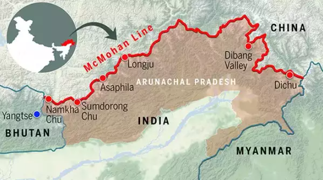
- And while China may lay claim to the entire state, its main interest lies in the district of Tawang, which is in the north-western region of Arunachal and orders Bhutan and Tibet. China’s interest in Tawang could be for tactical reasons as it provides a strategic entry into India’s northeastern region.
- Tawang is a critical point in the corridor between Tibet and Brahmaputra Valley.
Tawang monastery issue
- Besides Tawang also hosts the Tawang Ganden Namgyal Lhatse (Tawang Monastery), which is the second largest monastery of Tibetan Buddhism in the world.
- The monastery was founded by Merag Lodroe Gyamtso in the year 1680-81 to honor the wishes of the 5th Dalai Lama.
- China claims that the monastery is evidence that the district once belonged to Tibet. They cite historical ties between the Tawang monastery and the Lhasa monastery in Tibet to support their claim over Arunachal.
- This despite the fact that the 1914 Simla convention, which included a Chinese representative on an equal footing with a Tibetan representative, gave birth to the McMahon Line separating Tibet from India in the eastern sector. It clearly defined the frontiers of the boundary between India and Tibet.
Cultural connections and China’s anxieties
- Tawang is an important center of Tibetan Buddhism. There are some tribes in the upper Arunachal region which have cultural connections to the people of Tibet. The Monpa tribal population practices Tibetan Buddhism and are also found in some areas of Tibet.
- According to some experts, China fears that the presence of these ethnic groups in Arunachal could at some stage give rise to a pro-democracy Tibetan movement against Beijing.
Political significance
- When the Dalai Lama escaped Tibet in 1959 amid China crackdown, he entered India through Tawang and stayed in the Tawang monastery for some time.
The Bhutan factor
- If Beijing were to gain control of Arunachal, it would mean that the kingdom of Bhutan would have China as its neighbour on both the western and eastern borders.
Infrastructure investments
- China has already engaged in massive construction of motorable roads to connect strategic points on Bhutan’s western side. According to reports, China wants to extend its roads from Doka La to Gamochin, which is under the guard of the Indian army. China’s efforts to move closer to the Siliguri corridor is a security threat for both India and Bhutan.
- What’s more, China is expanding its network of railway lines in the region which could give its military a huge advantage.
Strategic location of Arunachal Pradesh
- Arunachal’s strategic location Arunachal Pradesh is the closest location for India to target China with missiles. Also, Arunachal is the best location for
- India to deploy a multi-layered air defence system for possible attacks from China. Thus, control over Arunachal will give China a strategic advantage.
Water power
- We all know China has control over India’s water supply to the northeastern region. It has constructed several dams and can use water as a geo-strategic weapon against India by causing flooding or drought in the region.
- The Tsangpo river, which originates in Tibet, flows into India and is called Siang in Arunachal Pradesh before it becomes the Brahmaputra.
The McMahon Line
History behind it
- British India annexed Assam in northeastern India in 1826, by Treaty of Yandabo at the conclusion of the First Anglo-Burmese War (1824–1826). After subsequent Anglo-Burmese Wars, the whole of Burma was annexed giving the British a border with China’s Yunan province.
- In 1913–14, representatives of Britain, China, and Tibet attended a conference in Simla, India and drew up an agreement concerning Tibet’s status and borders. The McMahon Line, a proposed boundary between Tibet and India for the eastern sector, was drawn by British negotiator Henry McMahon on a map attached to the agreement.
- All three representatives initialled the agreement, but Beijing soon objected to the proposed Sino-Tibet boundary and repudiated the agreement, refusing to sign the final map on the ground that Tibet was subordinate to China and had not the power to make treaties.
- Chinese have maintained this position to the present day and also have claimed that Chinese territory extends southward to the base of the Himalayan foothills.
- This frontier controversy with independent India led to the Sino-Indian hostilities of October–November 1962. In that conflict the Chinese forces occupied Indian territory south of the McMahon Line but subsequently withdrew after a cease-fire had been achieved.
India’s stand on McMahon Line
- India believes that when the McMahon Line was established in 1914, Tibet was a weak but independent country, so it has every right to negotiate a border agreement with any country.
- According to India, when the McMahon Line was drawn, Tibet was not ruled by China. Therefore, the McMahon Line is the clear and legal boundary line between India and China.
- Even after the Chinese occupancy over Tibet in 1950, the Tawang region remained an integral part of India.
Current status on the McMahon Line
- India recognizes the McMahon Line and considers it to be the ‘Actual Line of Control (LAC)’ between India and China, while China does not recognize the McMahon Line. China says that the area of the disputed area is 2,000 kilometers while India claims it is 4,000 kilometers.
- This land dispute between India and China is in Tawang (Arunachal Pradesh), which China considers as the Southern part of Tibet. Whereas according to the Shimla Agreement it is a part of the Indian state Arunachal Pradesh.
- Thus, it is clear that China rejects almost every treaty that it had approved before the communist revolution. This is true about the Panchsheel agreement also.
-Source: The Hindu
La Ninã conditions enter 3rd year, 6th time since 1950
Context:
La Niña years are infamous for frequent and intense hurricanes and cyclones in the Atlantic Ocean and the Bay of Bengal.
Relevance:
GS-I: Geography (Climatology, Important Geophysical Phenomena), GS-III: Environment and Ecology (Environmental Pollution and Degradation, Impact of Climate Change)
Dimensions of the Article:
- Details
- La Niña
- El Niño
- Impact on India
- ENSO
Details:
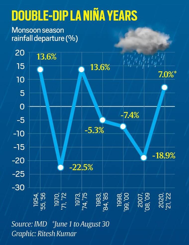
- La Ninã conditions prevailing over the equatorial Pacific Ocean since September 2020 has entered the third year. Such phenomenon is very uncommon.
- As per the date released by the India Meteorological Department (IMD), there are only six instances of La Ninã lasting for more than two years since 1950s.
- This year, India has received 740.3mm rainfall which was quantitatively 7 per cent above the seasonal average till August 30. Out of the 36 states/Union Territories, 30 have received rainfall categorised as ‘normal’ or ‘excess’ or ‘large excess’.
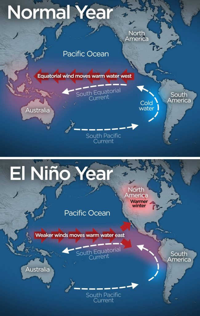
- The opposite is El Niño, that is, warmer SSTs prevail over these regions.
- La Ninã conditions will stay till the end of 2022.
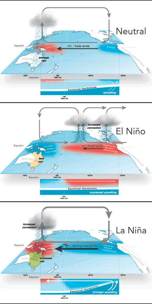
La Niña
- La Niña is a coupled ocean-atmosphere phenomenon that is the colder counterpart of El Niño, as part of the broader El Niño–Southern Oscillation (ENSO) climate pattern.
- During a period of La Niña, the sea surface temperature across the equatorial Eastern Central Pacific Ocean will be lower than normal by 3 to 5 °C (5.4 to 9 °F).
- An appearance of La Niña persists for at least five months.
- It has extensive effects on the weather across the globe, particularly in North America, even affecting the Atlantic and Pacific hurricane seasons, in which more tropical cyclones occur in the Atlantic basin due to low wind shear and warmer sea surface temperatures, while reducing tropical cyclogenesis in the Pacific Ocean.
- La Niña is a complex weather pattern that occurs every few years, as a result of variations in ocean temperatures in the Equatorial Pacific.
- It occurs as strong winds blow warm water at the ocean’s surface from South America across the Pacific Ocean towards Indonesia.
- As this warm water moves west, cold water from the deep sea rises to the surface near South America.
- As a result, it is considered to be the cold phase of the broader El Niño–Southern Oscillation weather pattern, as well as the opposite of El Niño weather pattern.
- La Niña impacts the global climate and disrupts normal weather patterns, which as a result can lead to intense storms in some places and droughts in others.
El Niño
- El Niño is the warm phase of the El Niño–Southern Oscillation (ENSO) and is associated with a band of warm ocean water that develops in the central and east-central equatorial Pacific (between approximately the International Date Line and 120°W), including the area off the Pacific coast of South America.
- The ENSO is the cycle of warm and cold sea surface temperature (SST) of the tropical central and eastern Pacific Ocean.
- El Niño is accompanied by high air pressure in the western Pacific and low air pressure in the eastern Pacific.
- During the development of El Niño, rainfall develops between September–November.
- The cool phase of ENSO is La Niña, with SSTs in the eastern Pacific below average, and air pressure high in the eastern Pacific and low in the western Pacific.
- The ENSO cycle, including both El Niño and La Niña, causes global changes in temperature and rainfall.
Impact on India
- El Nino creates warm conditions over the Indian subcontinent in the winter and dry conditions and a lack of monsoon in the summer, whereas La Nina causes a better-than-normal monsoon in India.
- In an agricultural country like India, large departures from typical seasonal rainfall have a significant impact on agricultural output and hence the economy.
ENSO
- El Nino and the Southern Oscillation, also known as ENSO is a periodic fluctuation in sea surface temperature (El Niño) and the air pressure of the overlying atmosphere (Southern Oscillation) across the equatorial Pacific Ocean.
- El Nino and La Nina are complex weather patterns resulting from variations in ocean temperatures in the Equatorial Pacific Region. They are opposite phases of what is known as the ENSO cycle.
- El Nino and La Nina episodes typically last nine to 12 months, but some prolonged events may last for years.


