Context:
Over the years, many of Bihar’s districts have been facing serious challenges with recurrent and massive flooding.
Even in 2021 it has been a double whammy — of flooding and the novel coronavirus pandemic.
Relevance:
GS-III: Disaster and Management (Natural and Anthropogenic Disasters, Disaster Management in India), GS-I: Geography (Important Geophysical phenomena), GS-II: International Relations (India’s Neighbors, Foreign Policies affecting India’s Interests)
Dimensions of the Article:
- Concern regarding Flooding in Bihar
- History of Cooperation between Nepal and India regarding Floods
- Issues with Flood management alongside Nepal
- Measures to control floods in Himalayan Regions
Concern regarding Flooding in Bihar
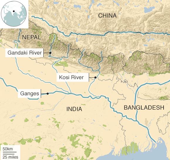
- Nepal’s three biggest river systems—Kosi, Gandaki and Karnali—originate in the high mountain glaciers, flow through the country and then enter India through the state of Bihar.

- About 65% of the catchment area of these rivers falls in Nepal/Tibet and only 35% of the catchment area lies in Bihar.
- During the monsoons, these river systems flood causing many problems for Bihar. The Government of Bihar has raised the matter at regular intervals. Despite the best efforts made by the Government of Bihar, the task remains unaccomplished even after 17 years.
- It is a necessity that there is process-driven coordination between the Centre and the Government of Bihar to handle the flooding in Nepal’s Terai and North Bihar (largely the Mithilanchal region).
- The history of floods in Bihar from 1998 to 2012 reveals how strong discharges of water due to heavy rains in the catchment areas of Nepal have created a strong pressure on the river embankments in India.
- About 76 per cent of the population living in northern Bihar live under threat of floods due to these river systems and a total of 73.06 per cent of the total geographical area of Bihar is flood affected (mostly during the monsoon).
- A study indicated that the plains of North Bihar have recorded the highest number of floods during the last 30-years. In the years 1978, 1987, 1998, 2004 and 2007, Bihar witnessed high magnitudes of flood.
- Flood of 2004 demonstrates the severity of the flood problem when a vast area of almost 24 thousand Sq Km was badly affected by the floods of Bagmati, Kamla & Adhwara groups of rivers causing loss of about 800 human lives, even when Ganga, the master drain was flowing low.
History of Cooperation between Nepal and India regarding Floods
- The history of cooperation between India and Nepal for embankments starting in the 1950s is worth looking at, which began when work on the Kosi embankments started in 1955 and a group of retired Nepali soldiers came over voluntarily to join hands with Indian volunteers and start the work.
- Such a progressive government-citizen interface could not sustain itself and water cooperation between the two countries for a common cause waned.
- Consequently, not much has happened barring the use of water resources for hydroelectric generation.
- The Kosi Treaty of 1954, under which the embankments in Nepal were established and maintained, was not futuristic and did not make enough provisions for the maintenance of embankments and the rivers changing their course.
- The deposition of stones, sand, silt and sediment has led to river beds rising, changing course and causing unimaginable losses. Between the mid-18th and mid-20th centuries, the Kosi is said to have shifted over 100 kilometres westward, resulting in large-scale human displacements. Also, there is a need for greater sensitisation on climatic imbalances and sustainable development.
- Ironically, the same flood-affected regions also face the issue of drought and a sinking water table.
- Clearly, course correction is needed to reestablish water cooperation as a common cause and draw inspiration for joint action from the 1950s.
Issues with Flood management alongside Nepal
- The Central Water Commission (CWC) has convened several meetings with Nepali Authorities.
- However, what is evident is Nepal’s lack of prompt reciprocation. India has long-standing water sharing issues with Nepal.
- As in the figures shared by Bihar, a total of four new flood protection works in the Gandak basin area were proposed before the floods of 2020. There were proposed Barrage structures located in the border districts. However, Nepal argues that many of the bund area falls into no man’s land along the open international border.
- This is notwithstanding the fact that the embankment was built by India 30 years ago and there has not been any dispute regarding its maintenance all these years.
- There is a need for India-Nepal collaboration for an efficiently operated barrage.
- It is evident that Nepal’s attitude towards mutual issues (water sharing, flood control, etc.) has been short of collaboration, unlike in the past.
Measures to control floods in Himalayan Regions:
Monitoring
- The first step in tackling the threat from these glacial lakes is to start monitoring them and the glaciers more actively and regularly. We do not need to monitor every glacier.
- Glaciers in one basin do not have remarkably different properties. If we identify one or two benchmark glaciers in every basin, those that are more easily accessible, and do detailed studies, then the results can be extrapolated to the rest of the glaciers in the basin or the state.
- The government of Uttarakhand itself takes a lead in this effort, and not be entirely dependent on outside agencies for monitoring or data. Afterall, Uttarakhand is the most vulnerable to natural disasters like these, and it must build capacities to reduce the risk.
Planning
- Construction-related activities in the state might not have a direct link to Sunday’s incident, but these are not entirely benign. The Himalayas are very young mountain systems, and extremely fragile.
- A minor change in orientation of the rocks can be enough to trigger landslides. It is important to include glaciers in any environment impact assessment for major projects such as construction of dams.
- The entire catchment areas should be made part of the impact assessment. In fact, project owners must be asked to invest in such studies. After all, their own assets are also at stake.
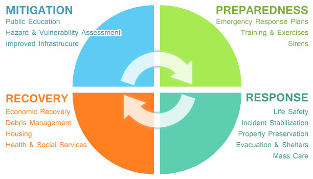
Mitigation
- If we monitor the glaciers regularly, it would enable us to identify the lakes that need mitigation solutions. Several structural and geotechnical measures can be applied, and there are successful examples where the threat from these lakes have been reduced.
- It is possible to construct channels for gradual and regulated discharge of water from these lakes, which will reduce the pressure on them, and minimise the chances of a breach.

-Source: The Hindu


