Context:
After a rather muted 2021 in terms of satellite launches, Indian Space Research Organisation (ISRO) is gearing up for a number of missions in 2022.
Relevance:
Prelims, GS-III: Science and Technology (Space Technology)
Dimensions of the Article:
- Chandrayaan-3
- Gaganyaan
- Aditya-L1
- XPoSat
- Indian Regional Navigation Satellite System
- Earth Observation Satellites
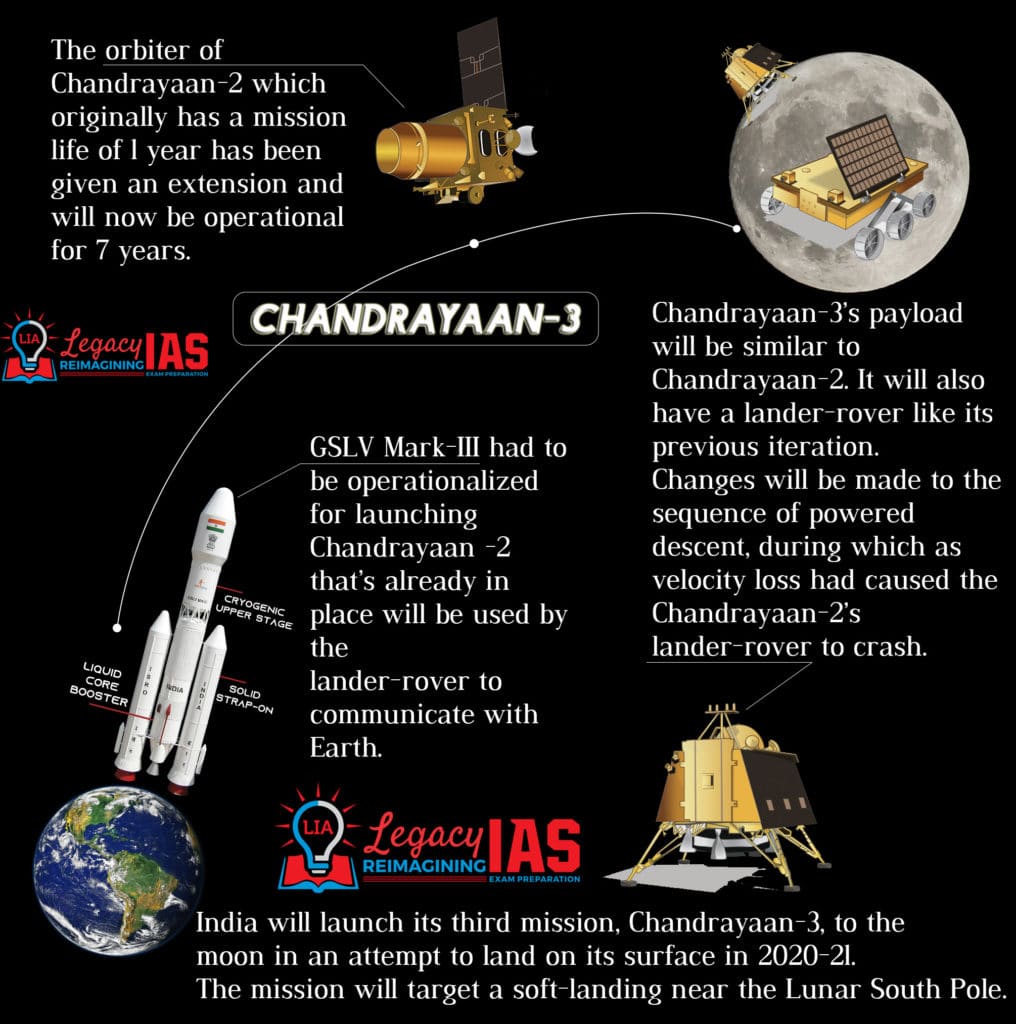
Chandrayaan-3
- The Chandrayaan-3 is the successor to the Chandrayaan-2 mission and it will likely attempt another soft-landing on the lunar surface.
- Chandrayaan-3 is a lander-and rover-specific mission, with the rover communicating with Earth via the existing orbiter from Chandrayaan-2 and taking images 100 km from Moon’s orbit.
- The unique exploration of Chandrayaan-3 aims at studying not just one area of the Moon but all the areas combining the exosphere, the surface as well as the sub-surface in a single mission.
- With Chandrayaan-1, ISRO achieved immense success as the ‘Moon Impact Probe’ by Chandrayaan-1 lunar remote sensing orbiter detected water in vapor form in trace amounts. With Chandrayaan-3, India aims to further the study of the lunar surface, focussing on the dark side of the Moon that has not seen sunlight in billions of years, which is believed to have ice and vast mineral reserves.
- The Lunar South pole is especially interesting because the lunar surface area that remains in shadow is much larger than that at the North Pole. Further, there could be a possibility of the presence of water in permanently shadowed areas around it. In addition, the South Pole region has craters that are cold traps and contain a fossil record of the early Solar System.
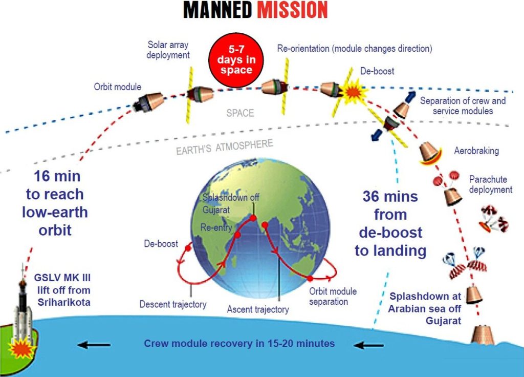
Gaganyaan
- Under the Gaganyaan 3 flights will be sent into orbit of which two are unmanned flights and one is human spaceflight.
- The Gaganyaan system module, called the Orbital Module will have three Indian astronauts, including a woman.
- It will circle Earth at a low-earth-orbit at an altitude of 300-400 km from earth for 5-7 days.
- GSLV Mk III, also called the LVM-3 (Launch Vehicle Mark-3,) the three-stage heavy lift launch vehicle, will be used to launch Gaganyaan as it has the necessary payload capability.
- Gaganyaan will involve numerous agencies, laboratories, disciplines, industries and departments. It will help in enhancement of science and technology levels in the country and help inspire youth.
- It will help in improving international collaboration along with the development of technology for social benefits.
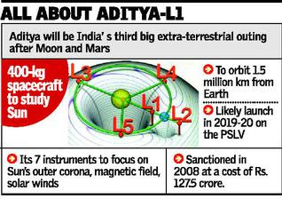
Aditya-L1
- Aditya-L1 is India’s first solar mission to study the Sun designed and to be built in collaboration between the Indian Space Research Organisation (ISRO) and various Indian research institutes.
- It is planned to be launched on the PSLV-C56 and it is now planned to be a comprehensive solar and space environment observatory to be placed at the Lagrangian point L1.
- The Aditya-L1 mission will be inserted in a halo orbit around the L1 point, which is about 1.5 million km from Earth.
- Aditya-L1 will be able to provide observations of Sun’s photosphere, chromosphere and corona.
- Aditya L1 will be ISRO’s 2nd space-based astronomy mission after AstroSat, which was launched in 2015.
Objectives of Aditya-1
- One of the major unsolved issues in the field of solar physics is that the upper atmosphere of the Sun is 1,000,000 K (1,000,000 °C) hot whereas the lower atmosphere is just 6,000 K (5,730 °C).
- In addition, it is not understood how exactly the Sun’s radiation affects the dynamics of the Earth’s atmosphere on shorter as well as on longer time scale.
- The mission will obtain near simultaneous images of the different layers of the Sun’s atmosphere, which reveal the ways in which the energy may be channeled and transferred from one layer to another.
- Thus, the Aditya-L1 mission will enable a comprehensive understanding of the dynamical processes of the Sun and address some of the outstanding problems in solar physics and heliophysics.
XPoSat
- The X-ray Polarimeter Satellite (XPoSat) is a ISRO planned space observatory to study polarisation of cosmic X-rays.
- It is planned to be launched in the second quarter of 2022 on a Small Satellite Launch Vehicle (SSLV).
- The telescope is being developed by the Indian Space Research Organisation (ISRO) and the Raman Research Institute.
- The observatory will be placed in a circular low Earth orbit of 500–700 km (310–430 mi).
- Studying how radiation is polarised gives away the nature of its source, including the strength and distribution of its magnetic fields and the nature of other radiation around it. XPoSat will study the 50 brightest known sources in the universe, including pulsars, black hole X-ray binaries, active galactic nuclei, and non-thermal supernova remnants.
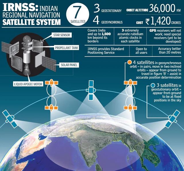
Indian Regional Navigation Satellite System
- IRNSS is an independent regional navigation satellite system developed by the Indian Space Research Organization (ISRO).
- The main objective is to provide reliable position, navigation and timing services over India and its neighbourhood.
- IRNSS is a regional and not a global navigation system.
- Unlike the widely used GPS which includes 24 satellites, NavIC has 8 satellites and their range is within India and its adjoining regions extending up to 1,500 km from the country’s border.
- Technically satellite systems with more satellites provide more accurate positioning information. However, compared to GPS which has a position accuracy of 20-30 metres, the NavIC is able to pinpoint location to an estimated accuracy of under 20 metres.
- The IRNSS constellation was named as “NavIC” (Navigation with Indian Constellation) by the Prime Minister, which provides two types of services:
- Standard Positioning Service (SPS) is meant for the general public.
- Restricted Service (RS) is an encrypted service meant for authorised users and agencies.
Earth Observation Satellites
- An Earth Observation Satellite or Earth Remote Sensing Satellite is a satellite used or designed for Earth Observance (EO) from orbit, including spy satellites and similar ones intended for non-military uses such as environmental monitoring, meteorology, cartography and others.
- The most common type are Earth imaging satellites, that take satellite images, analogous to aerial photographs; some EOS satellites may perform remote sensing without forming pictures, such as in GNSS radio occultation.
- The first occurrence of satellite remote sensing can be dated to the launch of the first artificial satellite, Sputnik 1, by the Soviet Union in 1957.
ISRO and EOS
- Starting with IRS-1A in 1988, ISRO has launched many operational remote sensing satellites.
- Currently 13 operational satellites are in Sun-synchronous orbit – RESOURCESAT-1, 2, 2A CARTOSAT-1, 2, 2A, 2B, RISAT-1 and 2, OCEANSAT-2, Megha-Tropiques, SARAL and SCATSAT-1, and *four* in Geostationary orbit- INSAT-3D, Kalpana & INSAT 3A, INSAT -3DR.
- The data from these satellites are used for several applications covering agriculture, water resources, urban planning, rural development, mineral prospecting, environment, forestry, ocean resources and disaster management.
- The launch of the Earth Observation Satellites, EOS-4 and EOS-6 on board the Polar Satellite Launch Vehicle (PSLV), and the EOS-02 on board the maiden flight of the Small Satellite Launch Vehicle (SSLV) are among the list of missions planned by the ISRO for 2022.
-Source: The Hindu
Legacy IAS Academy is ranked 1 IAS Coaching in India by top education portals. Join the Best IAS Coaching in Bangalore


