What is NISAR?
- NISAR (NASA-ISRO Synthetic Aperture Radar) is the first dual-frequency Earth Observation satellite jointly developed by NASA and ISRO.
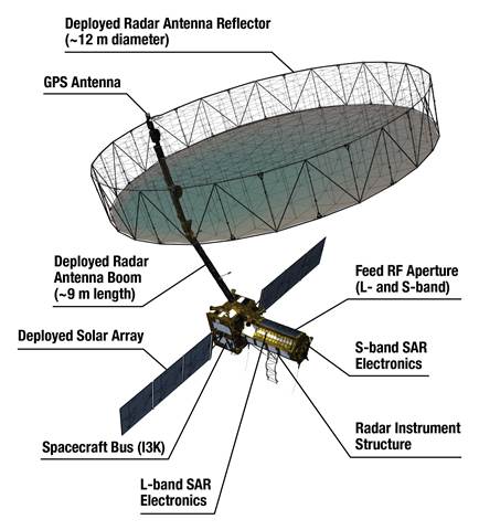
- Mass: 2,392 kg | Orbit: 743 km Sun-synchronous | Inclination: 98.4°
- Launch Vehicle: GSLV-F16 | Launch Site: Satish Dhawan Space Centre, Sriharikota | Launch Date: July 30, 2025, at 5:40 p.m.
Relevance : GS 3(Space , Science and Technology)
Key Technological Features
- Dual-Frequency Synthetic Aperture Radar (SAR):
- NASA’s L-band + ISRO’s S-band — a global first.
- Unfoldable Mesh Antenna:
- 12-meter NASA-built antenna deployed on ISRO’s I3K bus.
- High Spatial Resolution & Wide Swathe:
- 242 km wide swathe using SweepSAR technology.
- All-weather, Day-Night Imaging with 12-day repeat cycles.
Applications of NISAR
- Geophysical Monitoring:
- Detects subtle ground deformation (earthquakes, landslides, volcanoes).
- Ice sheet dynamics (Himalayas, Arctic, Antarctic).
- EnvironmentalStudies:
- Vegetation structure and biomass mapping.
- Soil moisture dynamics, forest degradation.
- Disaster Management:
- Real-time support for floods, cyclones, earthquakes.
- Supports NDMA and UN-SPIDER frameworks.
- Strategic Monitoring:
- Ship movement, sea ice classification, shoreline erosion.
India–US Space Collaboration Milestone
- Institutional Partners: NASA’s Jet Propulsion Laboratory (JPL) and ISRO.
- Marks over a decade of scientific collaboration — a major component of India–US strategic tech partnership.
- Supports Quadrilateral Security Dialogue (Quad) goals for disaster resilience and space domain awareness in Indo-Pacific.
Linkages with National Missions and Goals
- Supports:
- National Disaster Management Plan (NDMP).
- National Action Plan on Climate Change (NAPCC) — via glacier and water resource monitoring.
- Digital India (geospatial mapping).
- PM Gati Shakti and Natural Resource Management using satellite data.
Strategic & Policy Significance
- Positions India as a key player in global Earth observation infrastructure.
- Enhances India’s soft power in global science diplomacy.
- Reinforces India’s role in international climate action monitoring (e.g. under Paris Agreement, Global Methane Pledge).
Forward Outlook
- Data Sharing & Utilization Framework must be defined:
- Between ISRO, Indian ministries (MoEFCC, Jal Shakti, Agriculture), and international partners.
- Integration with public systems: Crop insurance, early warning systems, urban planning.
- Could shape future joint missions in deep space, asteroid mining, and lunar exploration under Artemis framework.


