Context:
China has completed construction of a strategically significant highway through the world’s deepest canyon in Tibet along the Brahmaputra river, enabling greater access to remote areas along the disputed border with Arunachal Pradesh in India.
Relevance:
GS-II: International Relations (India and its Neighborhood, Foreign Policies & Politics of Countries affecting India’s Interests)
Dimensions of the Article:
- About the Chinese Highway near Arunachal Pradesh Border
- China’s push in Border Infrastructure and reasons
- Concerns over Chinese transport-related infrastructure in Border
- Steps Taken by India to counter Chinese infrastructure in Border
- India’s Border Area Development Programme (BADP)
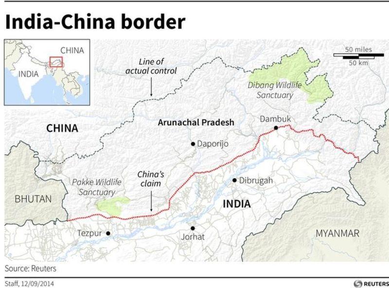
About the Chinese Highway near Arunachal Pradesh Border
- The Highway passes through the Grand Canyon of the Yarlung Zangbo river, as the Brahmaputra is called in Tibet. This is the “second significant passageway” to Medog county that borders Arunachal, directly connecting the Pad township in Nyingchi to Baibung in Medog county.
- The construction, which began in 2014, is part of a wider infrastructure push in border areas in Tibet.
- Recently, China has also started working on a strategically important railway line which is its second major rail link to Tibet that will link Sichuan province with Nyingchi, after the first rail link – Qinghai-Tibet railway that opened in 2006.
China’s push in Border Infrastructure and reasons
- A part of the border infrastructure push is the construction of new civilian settlements — along with the expansion of existing smaller hamlets — along border areas, some of which lie in disputed territories claimed by India and Bhutan, to strengthen China’s control over the land.
- In 2017, the Tibet Autonomous Region (TAR) government launched a plan to build “moderately well-off villages” in border areas, of which many would be developed in the prefectures of Ngari, Shigatse, Shannan and Nyingchi, along China’s borders with India, Bhutan and Nepal.
- In 2020, satellite images emerged showing a new village called Pangda built 2-3 km into what Bhutan sees as its land.
- In January 2021, another village built newly 4-5 km into what India sees as its territory in Arunachal came to light via satellite images. Indian officials said this land has been under China’s effective control since 1959 and there were military barracks there earlier.
- The civilian settlements, along with the new infrastructure connectivity, are seen as aimed at bolstering China’s control over the areas.
Concerns over Chinese transport-related infrastructure in Border
- Infrastructure such as the Highway in Arunachal Pradesh border or the Qinghai-Tibet railway line will largely improve the efficiency and convenience of military personnel and material transportation and logistical supplies in the border area.
- In situations of direct standoff near Arunachal Pradesh border, as was seen during Doklam or recent Ladakh standoff, China might be at an advantageous position – thanks to such roads and railway lines.
- The fragile ecological environment in the areas where such projects are undertaken by China, may have ecological concerns for India.
Steps Taken by India to counter Chinese infrastructure in Border
- The Border Roads Organisation (BRO) constructed the Daporijo bridge over Subansiri river in Arunachal Pradesh which links roads leading upto the Line of Actual Control (LAC) between India and China, in a record span of just 27 days.
- The foundation of a tunnel at Nechiphu in West Kameng district of Arunachal Pradesh which will shorten travel time for troops till the LAC through Tawang, which China claims to be its territory was laid.
- The BRO is already constructing an all-weather tunnel under the Se La pass in Arunachal Pradesh which connects Tawang to the rest of Arunachal and Guwahati.
- The state government of Arunachal Pradesh has advocated selection of 10 census towns along the India-China border as pilot projects for infrastructure development in order to stop people living along its international borders, specifically with China, from migrating to faraway urban centres in the State.
- Sisseri River Bridge located at lower Dibang Valley in Arunachal Pradesh connecting Dibang Valley and Siang was inaugurated.
- In 2019, the Indian Air Force inaugurated resurfaced runway at India’s easternmost Village-Vijaynagar (Changlang district) in Arunachal Pradesh.
- Bogibeel bridge, which is India’s longest road-rail bridge connecting Dibrugarh in Assam to Pasighat in Arunachal Pradesh was inaugurated in 2018.
- India is set to spend 10% funds of the Border Area Development Programme (BADP) only to improve the infrastructure along the China border.
India’s Border Area Development Programme (BADP)
- The Border Area Development Programme (BADP) was launched by the Ministry of Home Affairs in 1986-87 as part of a comprehensive approach to Border Management.
- BADP was initiated in the border areas of the western region during the Seventh Five Year Plan (1985-90), for ensuring balanced development of border areas through development of infrastructure and promotion of a sense of security among the border population.
- It is a centrally sponsored scheme. Funds are provided to the states as a non-lapsable special central assistance for the execution of projects relating to infrastructure, livelihood, education, health, agriculture and allied sectors.
- The States covered are Arunachal Pradesh, Assam, Bihar, Gujarat, Himachal Pradesh, Jammu & Kashmir, Manipur, Meghalaya, Mizoram, Nagaland, Punjab, Rajasthan, Sikkim, Tripura, Uttar Pradesh, Uttarakhand and West Bengal.
-Source: The Hindu


