GSAT-30
Why in news?
Recently, the Indian Space Research Organisation (ISRO) has launched telecommunication satellite GSAT-30 into a Geosynchronous Transfer Orbit (GTO) from Kourou launch base, French Guiana by European Ariane-5 VA-251.
Details:
- GSAT-30 satellite will replace INSAT-4A which was launched in 2005.
- A European communication satellite named EUTELSAT KONNECT was also launched with GSAT-30.
- GSAT-30 derives its heritage from ISRO’s earlier INSAT/GSAT satellite series and will replace INSAT-4A in orbit.
- GSAT-30 is configured on ISRO’s enhanced I-3K Bus structure to provide communication services from Geostationary orbit.
- It was launched from the foreign launcher because it is much heavier than the lifting capacity of its geostationary launch vehicle GSLV-MkII (It has the capacity to lift 2500kg).
- The GSLV-MkIII can lift up to 4,000 kg, but ISRO plans to use the upcoming MkIIIs mainly for its first human space flight Gaganyaan of 2022.
Services:
- It will provide DTH (direct to home) television services, connectivity to VSATs (that support working of banks’) ATMs, stock exchange, television uplinking and teleport services, digital satellite news gathering and e-governance applications.
- The satellite will also be used for bulk data transfer for a host of emerging telecommunication applications.
Area Coverage :
- The satellite provides Indian mainland and islands coverage in Ku-band and extended coverage in C-band covering Gulf countries, a large number of Asian countries and Australia.
RISAT-2BR1
Why in news?
Recently, India’s Polar Satellite Launch Vehicle (PSLV-C48) marked its 50th launch by injecting India’s advanced radar imaging earth observation satellite RISAT-2BR1.
- PSLV-C48 also injected 9 other customer satellites from Japan, Italy, Israel and the U.S.A. into their intended orbits.
- This was 75th launch vehicle mission from Satish Dhawan Space Centre, Sriharikota.
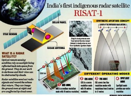
What is RISAT-2BR1?
It is a radar imaging earth observation satellite.
RISAT-2BR1 is expected to bolster the country’s border monitoring measures besides aiding in disaster management, agriculture and tracking forest cover.
Its mission life is 5 year
It is equipped with a Synthetic Aperture Radar (SAR) that can take pictures of the earth both during the day and night, irrespective of the cloud conditions.
Background:
Polar Satellite Launch Vehicle
- It is a four-staged launch vehicle with first and third stage using solid rocket motors and second and fourth stages using liquid rocket engines.
- It is the first Indian launch vehicle to be equipped with liquid stages.
- Initially, PSLV had a carrying capacity of 850 kg but has been enhanced to 1.9 tonnes.
- The PSLV has helped take payloads into almost all the orbits in space including Geo-Stationary Transfer Orbit (GTO), the Moon, Mars and would soon be launching a mission to the Sun.
- Between 1994 and 2019, the PSLV launched 50 Indian satellites and 222 foreign satellites for over 70 international customers from 20 countries.
- It has a history of successful launches of payloads that include Chandrayaan-1, Mars Orbiter Mission(MOM) and the space recovery mission, etc.
- The PSLV has failed only twice in its history — the maiden flight of the PSLV D1 in 1993 and the PSLV C-39 in 2017.
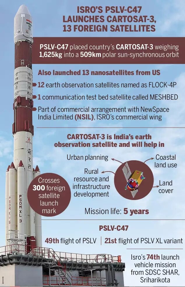
Cartosat-3
India’s Polar Satellite Launch Vehicle, PSLV-C47 has launched Cartosat-3 and 13 commercial nanosatellites into Sun Synchronous orbit from Satish Dhawan Space Centre (SDSC) SHAR, Sriharikota.
Details:
It is a third-generation agile advanced earth observation satellite with high-resolution imaging capability.
Developed by the Indian Space Research Organization (Isro), it will replace the IRS series.
It will be placed in an orbit of 509 km at an inclination of 97.5 degree.
Till date, eight Cartosats have been launched by ISRO.
Applications
- Data from most of the Cartosat satellites are exclusively used by the armed forces.
- However, an existing policy allows only government and government authorised agencies to access ISRO’s high-resolution imageries below a resolution of 1 metre.
- Cartosat-3’s optical imaging will also help to detect precise cartographic or mapping activities.
- The imageries are also used for urban and rural infrastructure planning, coastal land use and regulation, utility management such as monitoring road networks, water grids or distribution, creation of land use maps, disaster management, etc.
Background:
- The Cartosat satellites are earth observation satellites, used mainly for large-scale mapping of the Earth through high-resolution cameras.
- It also helps to detect changes in natural geographical or man-made features. As their cameras can `look back and forth’ in an angle to generate continuous spot images.
- The Earth-observation satellites also include the Resourcesat and RISAT series, the Oceansat series.
- The Resourcesat and RISAT series of satellites, for example, provide images and data that are needed for land and water resources applications.
- The Oceansat series and the SARAL satellite, meanwhile, produce data on the oceans.
- The satellites like INSAT 3D, INSAT-VRR or Megha Tropiques study the atmosphere.
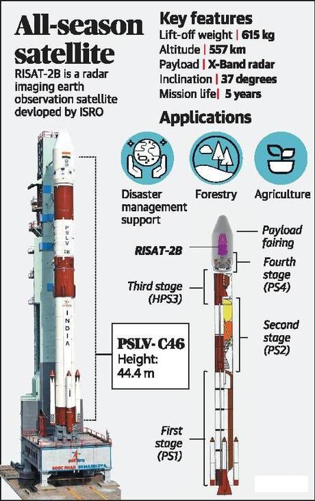
RISAT-2B
ISRO successfully launched radar imaging satellite RISAT-2B on-board PSLV-C46 from Sriharikota.
- RISAT-2B was placed into an orbit of 555 km with an inclination of 37 degree to the equator.
- This is the fourth flight unit of the RISAT programme and it would be used for reconnaissance, strategic surveillance and disaster management.
Details:
- The satellite has a mass of 615 kg and feature an X-band SAR (Synthetic Aperture Radar).
- It is built for a 5 year operational lifetime.
- RISAT 2B will be launched into a 37° inclined orbit at 555 km orbital height.
- RISAT 2B, RISAT 2BR1 and RISAT 2BR2 will be launched in 2019 on Indian PSLV launch vehicles.
Applications
- In India radar imaging are used for crop estimation because our main crop growing season of kharif is in May-September when it rains and gets cloudy.
- We have used this data extensively for forestry, soil, land use, geology and during floods and cyclone.
- Due to an all-weather seeing feature, the satellite becomes special for security forces and disaster relief agencies.
Chandrayaan-2 Mission
Chandrayaan-2’s features?
- Chandrayaan-2 is India’s first lander mission.
- It consists of an Orbiter, Lander and Rover, all equipped with scientific instruments to study the moon.
- The Lander and Rover modules will separate from the orbiter and make a soft-landing on moon’s surface (either on September 5 or 6, 2019).
- The lander and rover are designed to work for only 14 days (1 lunar day) while the orbiter would remain in orbit for a year.
Orbiter – The Orbiter would once again watch the moon from a 100-km
orbit.
- The Orbiter is a 2379-kg spacecraft with 7 instruments on board.
- It is equipped with different kinds of cameras to take high-resolution three-dimensional maps of the surface.
- It also has instruments to study the mineral composition on the moon and the lunar atmosphere, and to assess the abundance of water.
- The Orbiter will observe lunar surface and relay communication between Earth and the Lander.
Lander – ISRO has named the Lander module as Vikram, after Vikram
Sarabhai, the pioneer of India’s space programme.
- The 1471-kg lander will remain stationary after touching down on the moon’s surface.
- It will carry three instruments that will mainly study the moon’s atmosphere.
- One of the instruments will also look out for seismic activity on lunar surface.
Rover – The Rover is a 6-wheeled, Artificial Intelligence-powered
and solar-powered vehicle named Pragyan, meaning wisdom.
- Once on the moon, the rover will detach itself from the lander.
- Equipped with two instruments, it would slowly crawl on the surface, making observations and collecting data.
- Its primary objective is to study the composition of the moon’s surface near the landing site.
- It would also determine the abundance of different elements on the moon’s surface.

Mission Objectives
- Try and build on the evidence of water molecules shown by Chandrayaan-I and study the extent and distribution of water on the Moon
- Study topography, seismography, composition of lunar surface and the lunar atmosphere
- The study of ancient rocks and craters can offer indications of origin and evolution of the Moon.
- The South Pole region of the Moon also contains clues to the fossil records of early solar system. Thus, it will improve our understanding of the early solar system as well.
- Map the lunar surface and prepare 3D maps of it.
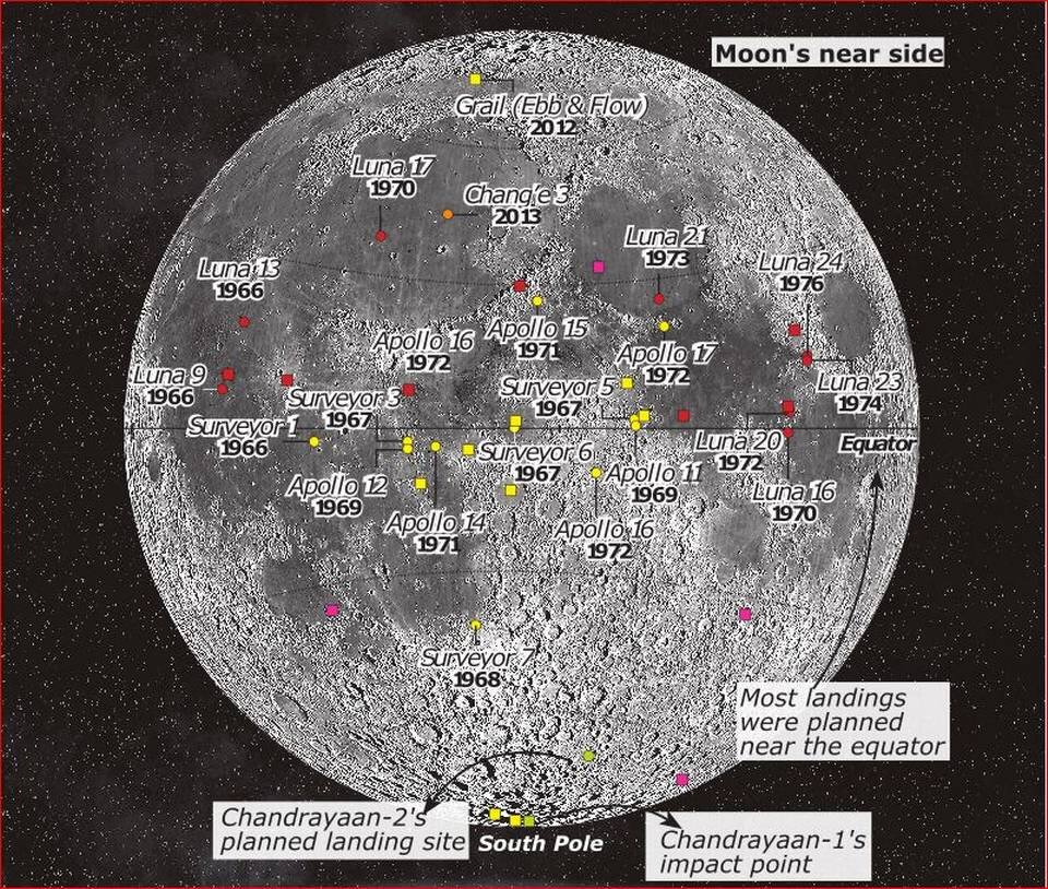
Chandrayaan 2 and every other moon mission mapped
Significance:
- With Chandrayaan-2, India will become only the 4th country in the world to land a spacecraft on the moon.
- So far, all landings, human as well as non-human, on the moon have been in areas close to its equator.
- This was mainly because this area receives more sunlight that is required by the solar-powered instruments to function.
- Chandrayaan-2 will make a landing at a site where no earlier mission has gone, near the South pole of the moon.
- It is a completely unexplored territory and therefore offers great scientific opportunity for the mission to discover something new.
- [Incidentally, the crash-landing of the MIP from the Chandrayaan-1 mission had also happened in the same region.]
- South pole – The south pole of the moon holds the possibility of the presence of water.
- This is one aspect that would be probed meticulously by Chandrayaan-2.
- In addition, this area is also supposed to have ancient rocks and craters.
- It can thus offer indications of history of moon, and also contain clues to the fossil records of early solar system.
Geotail and its impact on
Chandrayaan-2
- Recently, ISRO tweeted that an instrument on Chandrayaan-2, CLASS, had detected charged particles during the mission.
- This happened during the orbiter‘s passage through the ‗Geotail‘.
- The Geotail is a region in space that allows the best observations.
- The region exists as a result of the interactions between the Sun and Earth.
- The Sun emits the solar wind, which is a continuous stream of charged particles.
- These particles are embedded in the extended magnetic field of the Sun.
- Since the Earth has a magnetic field, it obstructs the solar wind plasma.
- This interaction results in the formation of a magnetic envelope around Earth.
- On the Earth side facing the Sun, the envelope is compressed into a region that is approximately 3 to 4 times
- the Earth radius.
- On the opposite side, the envelope is stretched into a long tail, which extends beyond the orbit of the Moon.
- It is this tail that is called the Geotail.
- Once every 29 days, the Moon traverses the geotail for about six days.
- When Chandrayaan-2, which is orbiting the Moon, crosses the geotail, its instruments can study the properties
- of the geotail.
- It can helps to detect the presence of key elements like Na, Ca, Al, Si, Ti and Fe the lunar soil.
India to Set Up its Own Space Station
Indian Space and Research Organization (ISRO) has announced its ambitious plan to put up a space station in the next decade.
Details:
- The Indian space station will be much smaller (mass of 20 tonnes) than the International Space Station and will be used for carrying out microgravity experiments (not for space tourism).
- Preliminary plan for the space station is to accommodate astronauts for up to 20 days in space, and the project will be an extension of the Gaganyaan mission.
- It will orbit Earth at an altitude of around 400km.
- ISRO (Indian Space Research Organisation) is working on space docking experiment (Spadex), a technology that is crucial for making the space station functional.
- space docking is a technology that allows transferring humans from one spacecraft to another.
- The International space station (ISS) is currently the only active space station in the earth‘s orbit.
- ISS is a joint project between five participating space agencies NASA (USA), Roscosmos (Russia), JAXA (Japan), ESA (Europe), and CSA (Canada).
Bhuvan Panchayat 3.0
Recently an upgraded geo-imaging web portal, Bhuvan Panchayat 3.0 was launched during the National Workshop on “Space-based Information Support for Decentralised Planning-2″.
The launch is part of the advanced Space-based Information Support for Decentralised Planning (SISDP) project.
Services: This version of the portal will provide database visualisation and services for the benefit of panchayat members, among others.
The targeted audiences for this portal are Public, PRIs and different stakeholders belonging to the gram panchayats.
Features:
Using Bhuvan satellite imagery, hi-resolution database at 1:10,000 scale is applied to identify land use land cover, settlements, road and rail network etc. The portal offers database visualization, data analytics, generation of automatic reports, model-based products and services for Gram Panchayat members and other stake-holders.
Implementation:
In the project that will last for at least two years, ISRO will collaborate with the gram panchayat members and stakeholders to understand their data requirements.
Significance:
The project is meant to provide geo-spatial services to aid gram panchayat development planning process of the Ministry of Panchayati Raj.
Background:
Bhuvan, as a platform, is open and can be used by a diverse user community such as Central and State Governments Departments, Academia and Industry. Few examples are:
- Bhuvan-Bhujal: Ground Water Prospects Information System
- School Bhuvan: An e-learning portal for the students
- ENVIS program of Ministry of Environment, Forests & Climate Change
- Bhuvan Ganga: Enables people participation in providing vital information for Clean Ganga project
- Srishti-Drishti: An Integrated Watershed Development Program
Vyom Mitra: Lady Robot for Gaganyaan:
Vyommitra, a half-humanoid is being developed by the Indian Space Research Organisation (ISRO) for an unmanned space mission later in 2020.
Details:

- ISRO’s Vyommitra (vyoma = space, mitra = friend) is the prototype for a “half-humanoid”.
- She is also being called a half-humanoid since she will only have a head, two hands and a torso, and will not have lower limbs.
- She is under development at a robotics laboratory at the Vikram Sarabhai Space Centre.
- She will fly to space on an unmanned mission later this year, aiming to lay the ground for ISRO’s manned mission Gaganyaan in 2022.
Background:
- A humanoid is basically a robot with the appearance of a human being.
- Like any robot, a humanoid’s functions are determined by the computer systems to which it is connected.
- With the growth of artificial intelligence and robotics, humanoids are being increasingly used for repetitive jobs.
- The artificial intelligence technologies are used in a humanoid to perform simple functions that include walking, moving things, communicating and obeying commands.
GEMINI Device
- To avoid communication blackouts that led to 20 fishermen going missing in the aftermath of Cyclone Okchi in 2017, a slew of government departments, research agencies and private companies have developed GEMINI.
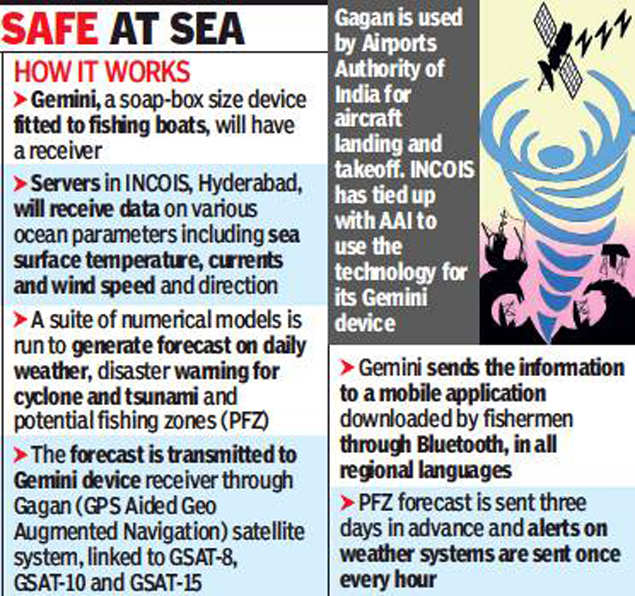
- Details:
- GEMINI is a portable receiver linked to ISRO-satellites, that is “fail-proof” and warn fishermen of danger.
- The Indian National Centre for Ocean Information Services (INCOIS), a Hyderabad institute collaborated with Accord, a private company, to develop a box-shaped receiver.
- It has an antenna and in-built battery that can last three to four days, according to a brochure describing the device.
- GEMINI works on GAGAN developed by ISRO and the Airports Authority of India and is an India-made global positioning system and relies on the positioning system by ISRO’s GSAT satellites.
Purpose:
- The device is developed for effective dissemination of emergency information and communication on Ocean States Forecast and mapping of Potential Fishing Zones (PFZ) to fishermen.
- Ocean States Forecast provides the accurate state of the ocean that includes the forecasts related to winds, waves, ocean currents, water temperature, etc.
- PFZ provide information about the probable locations of fish aggregation in the seas to the fishermen, while
- GEMINI is a portable receiver that is linked to ISRO-satellites. With this device, the fishermen outside the signal range of their phone companies (i.e. 10-12 km) can also access warnings and alerts, as the device can send signals up to 300 nautical miles.
- It will facilitate satellite-based communication that will be highly useful while dealing with cyclones, high waves, and tsunamis.
Background:
Indian National Centre for Ocean Information Services (INCOIS)
- INCOIS is an autonomous organization under the Ministry of Earth Sciences (MoES).
- It is located in Hyderabad & was established in 1999 under the MoES and is a unit of the Earth System Science Organization (ESSO).
- It is mandated to provide the best possible ocean information and advisory services to society, industry, government agencies and the scientific community through sustained ocean observations and constant improvement through systematic and focused research.
Aditya- L1 mission
It is India’s first solar mission. It will be launched using the Polar Satellite Launch Vehicle (PSLV) in XL configuration. The space-based observatory will have seven payloads (instruments) on board to study the Sun’s corona, solar emissions, solar winds and flares, and Coronal Mass Ejections (CMEs), and will carry out round-the-clock imaging of the Sun.
Key Facts:
- Aditya L1 will be ISRO’s 2nd space-based astronomy mission after AstroSat, which was launched in 2015.
- Aditya 1 was renamed as Aditya-L1. The Aditya 1 was meant to observe only the solar corona.
AstroSat
- AstroSat, was launched in September, 2015, by PSLV-C30 from Sriharikota (Andhra Pradesh).
- It is the first dedicated Indian astronomy mission aimed at studying celestial sources in X-ray, optical and UV spectral bands simultaneously.
Details:
- Objective: Aditya L1 will study the Sun’s corona (Visible and Near infrared rays), Sun’s photosphere (soft and hard X-ray), chromosphere (Ultra Violet ), solar emissions, solar winds and flares, and Coronal Mass Ejections (CMEs), and will carry out round-the-clock imaging of the Sun.
- Challenges: The distance of the Sun from Earth ( approximately 15 crore kms on average, compared to the only 3.84 lakh kms to the Moon).This huge distance poses a scientific challenge.
- Due to the risks involved, payloads in earlier ISRO missions have largely remained stationary in space; however, Aditya L1 will have some moving components which increases the risks of collision.
- Other issues are the super hot temperatures and radiation in the solar atmosphere. However, Aditya L1 will stay much farther away, and the heat is not expected to be a major concern for the instruments on board.
Significance:
- Effects of Variation in Solar Weather System: Variations in this weather can change the orbits of satellites or shorten their lives, interfere with or damage onboard electronics, and cause power blackouts and other disturbances on Earth.
- Knowledge of solar events is key to understanding space weather.
- To learn about and track Earth-directed storms, and to predict their impact, continuous solar observations are needed.
- Many of the instruments and their components for this mission are being manufactured for the first time in the country.
Background:
Lagrange Point 1
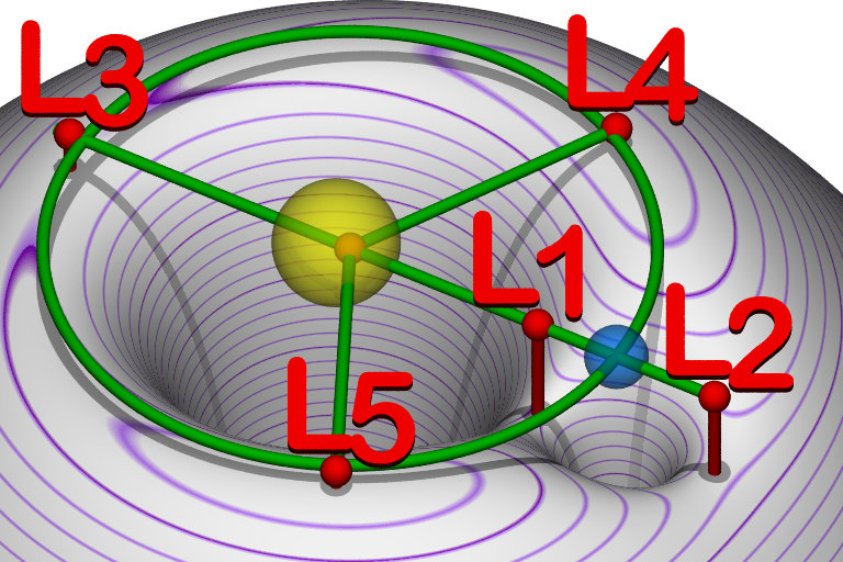
- Lagrange Points, named after Italian-French mathematician Josephy-Louis Lagrange, are positions in space where the gravitational forces of a two-body system (like the Sun and the Earth) produce enhanced regions of attraction and repulsion.
- The L1 point is about 1.5 million km from Earth, or about 1/100th of the way to the Sun.
- L1 refers to Lagrangian/Lagrange Point 1, one of 5 points in the orbital plane of the Earth-Sun system.
- These can be used by spacecraft to reduce fuel consumption needed to remain in position.
- A Satellite placed in the halo orbit around the Lagrangian point 1 (L1) has the major advantage of continuously viewing the Sun without any occultation/ eclipses.
- The L1 point is home to the Solar and Heliospheric Observatory Satellite (SOHO), an international collaboration project of National Aeronautics and Space Administration (NASA) and the European Space Agency (ESA).
Extra Notes for Prelims:
- NASA’s Parker Solar Probe’s aim is to trace how energy and heat move through the Sun’s corona and to study the source of the solar wind’s acceleration.
- It is part of NASA’s ‘Living With a Star’ programme that explores different aspects of the Sun-Earth system.
- The earlier Helios 2 solar probe, a joint venture between NASA and space agency of erstwhile West Germany, went within 43 million km of the Sun’s surface in 1976.
AstroSat
- It is a space observatory launched by ISRO in 2015.
- It was launched with a lift-off mass of about 1500 kg by PSLV-C30.
- It is India‘s first dedicated multi wavelength space observatory.
- Most other scientific satellites can observe only a narrow range of wavelength band.
- But AstroSat enables the simultaneous multi-wavelength observations of various astronomical objects with a single satellite.
- It observes universe in the optical, Ultraviolet, low and high energy X-ray regions of the electromagnetic
- spectrum.
The scientific objectives of ASTROSAT mission are:
1. To understand high energy processes in binary star systems containing neutron stars and black holes
2. Estimate magnetic fields of neutron stars
3. Study star birth regions and high energy processes in star systems lying beyond our galaxy
4. Detect new briefly bright X-ray sources in the sky
5. Perform a limited deep field survey of the Universe in the Ultraviolet region
The minimum useful life of the AstroSat mission is expected to be 5 years.
NISAR:
What is it?
NISAR stands for NASA ISRO Synthetic Aperture Radar Mission
Aims: To study the hazards and global environmental changes
When? Slated to launched in 2020-21
Details:
- NISAR is a dual frequency (L & S Band) Radar Imaging Satellite. It will be the first radar imaging satellite to use dual frequency.
- Will be launched in a Sun Synchronous Low -Earth
- It is designed to observe and take measurements of some of the planet’s most complex processes, including ecosystem disturbances, ice-sheet collapse, and natural hazards such as earth quakes, tsunamis, volcanoes and landslides.
- The satellite is likely to be launched from India aboard an Indian launch vehicle.
Applications:
- NISAR would provide info about a place more frequently. For Ex. If the present satellite take 23 to 25 days to revisit a particular spot and give the next round of info about it, NISAR would provide the repeat info in two to five days.
- Objectives:
- Estimation of soil moisture
- Agriculture and forest biomass
- Estimation of glacier
- Snow and possibility of landslide
ISRO’s Seven Mega Missions
The seven mega missions include:
- Chandrayaan-2.
- XPoSat (to study cosmic radiation in 2020) and Aditya-L1(to the Sun in 2021).
- Undefined Missions – which include missions which are still in planning stage namely Mangalyaan-2 (or Mars Orbiter Mission-2 in 2022), Lunar Polar Exploration (or Chandrayaan-3 in 2024), Venus mission (in 2023), Exoworlds (exploration outside the solar system in 2028).
About Xposat:
- The X-ray Polarimeter Satellite (or Xposat), is ISRO’s dedicated mission to study polarization. It will be launched launch in year 2020.
- It will be a five-year mission and will study cosmic radiation.
- It will be carrying a payload named ‘polarimeter instrument in X-rays’ (POLIX) made by Raman Research Institute. POLIX will study degree and angle of polarisation of bright X-ray sources in energy range 5-30 keV.
- The spacecraft will be placed in a circular 500-700km orbit.
Mission Venus
- ISRO has opened for its ―Mission Venus‖ seeking experiment ideas from space agencies, universities and researchers.
- It is planned to be launched in Mid-2023.
- It plans to study the planet from an elliptical orbit that is closest to Venus at 500 km and 60,000 km at the farthest end.
- It is currently being handled by the Space Science Programme Office.
- If the project is approved would be ISRO‘s third interplanetary mission after Chandrayaan – 1 and Mars Orbiter Mission.
Human Space Flight Centre (HSFC):
- India’s world-class facility for training astronauts will come up at Challakere, a shrubby, arid oilseeds town in Karnataka. will be the single-stop consolidating infrastructure and activities related to space travellers.
- It will be a self-contained facility there so that in future, whatever training and activities India is now doing in Russia for the Gaganyaan crew can all be done here
Indian Human Space Flight Programme:
ISRO aims to launch its maiden Human Space Mission, Gaganyaan before the 75th anniversary of India’s independence in 2022.
Objectives of the Mission:
- Enhancement of science and technology levels in the country
- A national project involving several institutes, academia and industry
- Improvement of industrial growth
- Inspiring youth
- Development of technology for social benefits
- Improving international collaboration
Background:
Challakere
- Challakere is a city in Chitradurga district in the state of Karnataka. India.
- It is called Oil city with numerous edible oil mills around the city.
- Challakere is famous for kambali (woven blankets) made by the local Kuruba people.
- It is also known as the “second Mumbai” of India because it is the second-largest producer/supplier of edible oil after Mumbai. There are as many as 60+ oil industries in Challakere.
New Space India Limited
- The establishment of NSIL was announced in Budget 2019.
- One of the mandates of NSIL is to mass-produce and manufacture the SSLV and the more powerful PSLV in partnership with the private sector in India through technology transfers.
- Its aim is to use research and development carried out by ISRO over the years for commercial purposes through Indian industry partners.
- It differs from ISRO’s existing commercial arm Antrix Corporation:
- Antrix will handle ISRO’s commercial deals for satellites and launch vehicles with foreign customers.
- NSIL will deal with capacity building of local industry for space manufacturing.
Background:
Small Satellite Launch Vehicle
- The SSLV is the smallest vehicle weighing only 110-tonne.
- It would take only 72 hours to integrate, unlike the 70 days taken for launch vehicles like Polar Satellite Launch Vehicle (PSLV) or Geosynchronous Satellite Launch Vehicle(GSLV).
- Cost-effective: Its cost would be around Rs. 30 crores.
- It will be an on-demand vehicle.
- SSLV is perfectly suited for launching multiple microsatellites at a time and supports multiple orbital drop-offs.
- The SSLV can carry satellites weighing up to 500 kg to Low Earth Orbit while the PSLV can launch satellites weighing in the range of 1,000 kg.
- A low Earth orbit (LEO) is an orbit around Earth with an altitude above the Earth’s surface of 2,000 kilometres (1,200 mi), and an orbital period between about 84 and 127 minutes.
- ISRO’s SSLV was originally scheduled to have its first development flight on July 2019 but got delayed to end of 2019.
Read Useful Articles
NASA-GLOBAL SPACE MISSIONS FOR UPSC EXAM
SPACE TECHNOLOGY AND TELESCOPES FOR UPSC EXAM
Join India’s Best IAS Coaching in Bangalore– Legacy IAS Academy.


