India State of Forest Report 2019
- The India state of Forest report is published by the Forest Survey of India (FSI).
- FSI has been mandated to assess the forest and tree resources of the country including wall-to-wall forest cover mapping in a biennial cycle.
- Starting 1987, 16 assessment have been completed so far. ISFR 2019 is the 16th report in the series.
Key Findings
- Forest Cover
- Forest Cover (Area-wise) : Madhya Pradesh> Arunachal Pradesh> Chhattisgarh> Odisha> Maharashtra.
- Forest Cover (Percentage): Mizoram (85.4%)> Arunachal Pradesh (79.63%)> Meghalaya (76.33%)
- Increase in Forest Cover
- The country’s forest cover includes all patches of land with a tree canopy density of more than 10% and more than 1 hectare in area, irrespective of land use, ownership and species of trees.
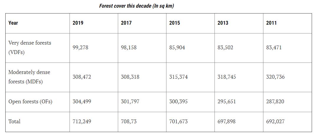
- The total forest cover of the country is 7,12,249 sq km which is 21.67% of the geographical area of the country.
- The top five states
- Mizoram (85.41%)
- Arunachal Pradesh (79.63%)
- Meghalaya (76.33%)
- Manipur (75.46%)
- Nagaland (731%)
- Decline of Forest Cover in North Eastern Region
- Total forest cover in the North Eastern region is 1,70,541 sq km, which is 65.05% of its geographical area.
- There has been a decrease of forest cover to the extent of 765 sq km (0.45%) in the region. Except Assam and Tripura, all the States in the region show decrease in forest cover.
- Forest Cover in Tribal Districts
- The total forest cover in the tribal districts is 4,22,351 sq km, which is 37.54% of the geographical area of these districts.
- There has been a decrease of 741 sq km of forest cover within the Recorded Forest Area/ Green Wash (RFA/GW) in the tribal districts and an increase of 1,922 sq km outside.
- There has been a decline in tree cover inside forests due to tribal populations getting “land titles” (patta) and there has been a rise in trees outside the forest area due to an increase in tree plantation and afforestation activities.
- Increase in the tree cover
- Tree cover comprises of tree patches of size less than 1 hectare occurring outside the recorded forest area.
- The tree cover of the country is estimated as 95,027 sq km which is 2.89% of the geographical area.
- Maharashtra has had the highest increase in tree cover and a large part of that is due to horticulture.
- In comparison to 2017
- The 2019 survey has found an increase of 5,188 sq km in total forest and tree cover in the country.
- Tree and forest cover together made up 24.56% (8,07,276 sq km) of India’s area. In the last assessment it was 24.39%.
- The nation’s tree and forest cover has largely hovered from 21-25% and is short of the National Forest Policy, 1988, which envisages 33% to be under such cover.
- Mangrove cover in the country has increased by 54 sq km (1.10%) as compared to the previous assessment.
- Carbon Stock
- The total carbon stock of the country was estimated at 7124 million tons, which is an increase of 42.6 million tons from the last assessment.
- It implies that India is on the right track to achieve its Paris Agreement commitment of 2.5 -3 billion carbon sinks.
- Wetlands
- The total number of wetlands located within the RFA/GW is 8.13%.
- Amongst the States, Gujarat has the largest area of wetlands within RFA in the country followed by West Bengal.
- Forest Produce
- Dependence of fuelwood on forests is the highest in the State of Maharashtra, whereas, for fodder, small timber and bamboo, dependence is highest in Madhya Pradesh.
- The analysis reveals that 21.40% of the forest cover of the country is highly to extremely fire prone.


